- Maplesville, Alabama
-
Maplesville, Alabama — Town — Location in Chilton County and the state of Alabama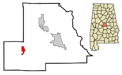
Coordinates: 32°46′55″N 86°52′32″W / 32.78194°N 86.87556°W Country United States State Alabama County Chilton Area - Total 3.3 sq mi (8.6 km2) - Land 3.3 sq mi (8.5 km2) - Water 0 sq mi (0.1 km2) Elevation 351 ft (107 m) Population (2000) - Total 672 - Density 203.6/sq mi (78.1/km2) Time zone Central (CST) (UTC-6) - Summer (DST) CDT (UTC-5) ZIP code 36750 Area code(s) 334 FIPS code 01-46504 GNIS feature ID 0160032 Maplesville is a town in Chilton County, Alabama, United States. At the 2000 census the population was 672.
Geography
Maplesville is located at 32°46'54.800" North, 86°52'31.861" West (32.781889, -86.875517)[1].
According to the U.S. Census Bureau, the town has a total area of 3.3 square miles (8.5 km2), of which, 3.3 square miles (8.5 km2) of it is land and 0.04 square miles (0.10 km2) of it (0.91%) is water.
Demographics
As of the census[2] of 2007, there were 2500 people, 268 households, and 183 families residing in the town. The population density was 205.8 people per square mile (79.6/km²). There were 313 housing units at an average density of 95.9 per square mile (37.1/km²). The racial makeup of the town was 69.94% White, 29.61% Black or African American and 0.45% Native American. 0.89% of the population were Hispanic or Latino of any race.
There were 268 households out of which 32.8% had children under the age of 18 living with them, 52.2% were married couples living together, 11.9% had a female householder with no husband present, and 31.7% were non-families. 30.2% of all households were made up of individuals and 12.7% had someone living alone who was 65 years of age or older. The average household size was 2.51 and the average family size was 3.13.
In the town the population was spread out with 25.3% under the age of 18, 10.1% from 18 to 24, 26.9% from 25 to 44, 23.5% from 45 to 64, and 14.1% who were 65 years of age or older. The median age was 37 years. For every 100 females there were 95.9 males. For every 100 females age 18 and over, there were 88.0 males.
The median income for a household in the town was $27,500, and the median income for a family was $36,250. Males had a median income of $31,042 versus $22,361 for females. The per capita income for the town was $12,777. About 12.6% of families and 20.1% of the population were below the poverty line, including 26.7% of those under age 18 and 16.0% of those age 65 or over.
References
- ^ "US Gazetteer files: 2010, 2000, and 1990". United States Census Bureau. 2011-02-12. http://www.census.gov/geo/www/gazetteer/gazette.html. Retrieved 2011-04-23.
- ^ "American FactFinder". United States Census Bureau. http://factfinder.census.gov. Retrieved 2008-01-31.
Coordinates: 32°46′55″N 86°52′32″W / 32.781889°N 86.875517°W
Municipalities and communities of Chilton County, Alabama County seat: Clanton Cities 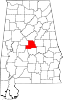
Towns Unincorporated
communitiesMountain Creek | Stanton
Footnotes ‡This populated place also has portions in an adjacent county or counties
Categories:- Towns in Alabama
- Populated places in Chilton County, Alabama
- Birmingham–Hoover metropolitan area


Wikimedia Foundation. 2010.