- Mount Maya
-
Mount Maya 摩耶山 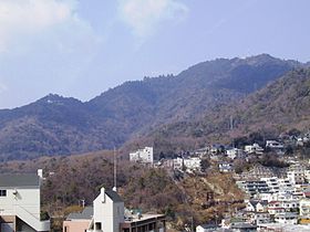
A View of Mount Maya from Kobe UniversityElevation 698.6 m (2,292 ft) Location Location Kobe, Hyōgo, Japan Range Rokko Mountains Coordinates 34°43′N 135°12′E / 34.717°N 135.2°ECoordinates: 34°43′N 135°12′E / 34.717°N 135.2°E Mount Maya (摩耶山 Maya-san) is a 698.6 m (2,292 ft) high mountain in Kobe, Hyōgo Prefecture, Japan. This mountain is one of the major peaks of the Rokkō Mountains, and is the most popular peak for visitors on the West-Rokkō Mountains.
Contents
Outline
Mount Maya is one of the two centers in Rokko Mountains for tourists. Like the area around the Kinenhidai, Mount Maya has a link from the foot of the mountain to the top. Those are Maya Cableway and Maya Ropeway. This mountain has also easy access to the foot through Okumaya Driveway. Mount Maya area was linked to Kinenhidai area and the top of Mount Rokko by bus. This mountain is a part of Setonaikai National Park, and famous for the view from the mountain. Especially from Kikuseidai, a park just aside of the top of the mountain, visitor can see all over Osaka Bay area including, Kobe, Nishinomiya, Amagasaki, Osaka, Sakai, and two major airports in this area, Kansai International Airport and Kobe Airport. The night-view is called ten million dollar night view and is one of Japan's top 3, along with Hakodate and Nagasaki. This mountain is also selected as one of Kinki 100 mountain and also one of Hyogo 50 mountains.
History
The history of Mount Maya is closely linked to that of Tenjō-ji temple. Tenjo-ji temple was said to be established 646 by High Monk Hodo, at the Emperor Kotoku's behest. In the 8th century, another High Monk Kobo brought back a statue of Maya, the mother of Buddha from China, and dedicated it to this temple. Needless to say, the name of this mountain has its origin in this story.
Tenjo-ji was an influential temple for a long time, but the original temple which was located very near to the top of the mountain was burned by a pyromaniac in 1975. The temple has been reestablished at a northern and higher place from the original.
Access
There are a lot of ways to reach to the peak of the mountain. These routes are by cableway and rope way:
- Maya Cable Shita – (Maya Cable) - Niji no Eki – (Maya Ropeway) – Hoshi no Eki
- Rokko Cable Shita – (Rokko Cableway) – Rokko Sanjo – (Rokko Maya Sky-Shuttle Bus) – Mount Maya
- Kitano Itchome - (Shinkobe Ropeway) – Nunobiki Hurb Garden – (Walk) – Mount Maya
- Shin-Kobe Station – (Walk: Kyumayado - Gakko Rindo - Tengumichi) – Mount Maya
- Maya Cable Shita – (Walk: Uenomichi) – Mount Maya
Gallery
 Panoramic view from the mount
References
Categories:- Visitor attractions in Hyōgo Prefecture
- Mountains of Hyōgo Prefecture
- Kobe


Wikimedia Foundation. 2010.