- Skykomish River
-
For the city of the same name, see Skykomish, Washington. For the similarly named river also in Washington State, see Skokomish River.
Skykomish River River 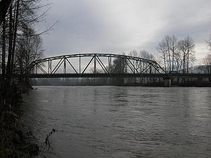
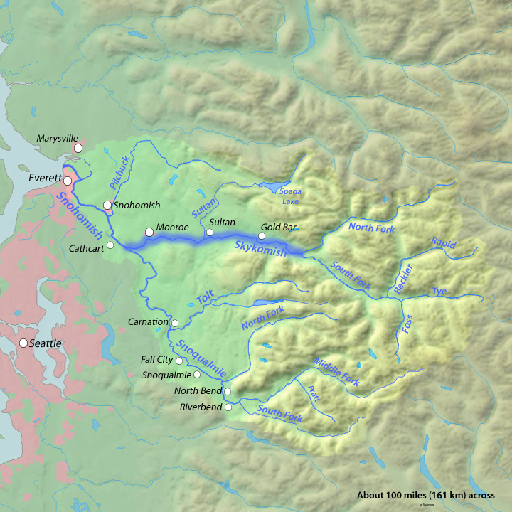
Country United States State Washington County Snohomish County, King County Source Confluence of the North and South Forks - coordinates 47°48′47″N 121°34′41″W / 47.81306°N 121.57806°W [1] Mouth Snohomish River - location Monroe - coordinates 47°49′49″N 122°2′48″W / 47.83028°N 122.04667°W [1] Length 29 mi (47 km) [2] Basin 834 sq mi (2,160 km2) [3] 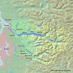 Map of the Skykomish River highlighted in the Snohomish River watershed
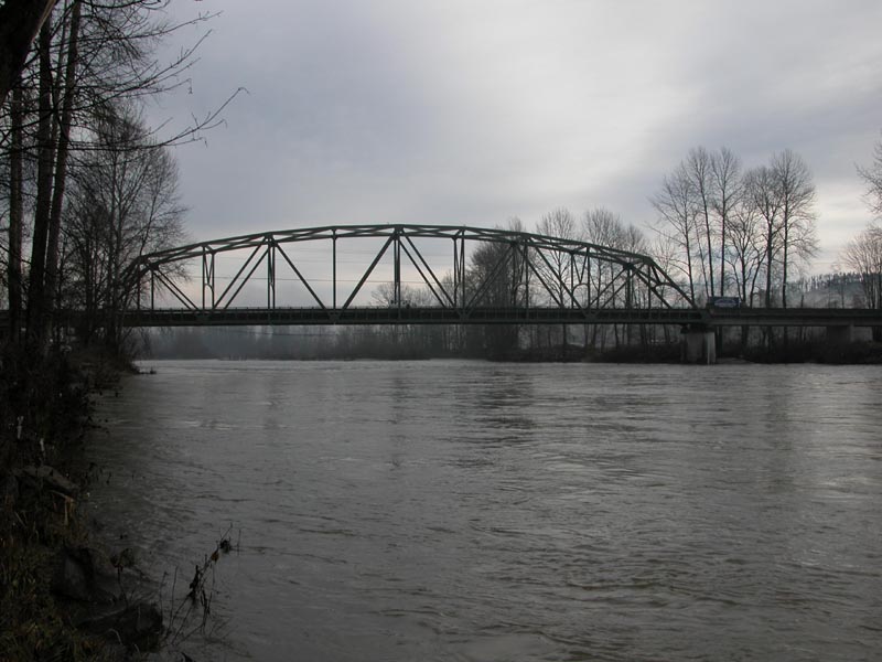
 Mouth of the Skykomish River in Washington
The Skykomish River is a Washington river which drains the west side of the Cascade Mountains in the southeast section of Snohomish County and the northeast corner of King County. The river starts with the confluence of the North Fork Skykomish River and South Fork Skykomish River approximately one mile west of Index, then flowing northwesterly towards Puget Sound. It is joined by the Sultan River and the Wallace River at Sultan. It then meets the Snoqualmie River to form the Snohomish River at Monroe. The Snohomish River continues along the river valley eventually dumping into Port Gardner Bay on Possession Sound (part of Puget Sound).
The Skykomish River's main stem is 29 miles (47 km) long. The length including its headwater tributaries, South Fork Skykomish and Tye River, is 62.4 miles (100 km).[2] The Skykomish's drainage basin is 834 square miles (2,160 km2) in area.[3]
United States Highway 2 and the BNSF Railway are routed to follow the Skykomish River, South Fork Skykomish, and Tye River to Stevens Pass and the Cascade Tunnel.
The Skykomish is sometimes referred to by the nickname "Sky River" or "The Sky".
According to Fred Beckey the North Fork and South Fork are about equal in size and neither is clearly the main course of the Skykomish River. However, the South Fork's true source, in terms of streamflow, is the Rapid River, a tributary of the Beckler River, which in turn is a tributary of the South Fork Skykomish.[4]
The name "Skykomish" comes from the Northern Lushootseed word /sq'íxʷəbš/, meaning "upriver people", from /q'íxʷ/, "upstream". It is the name of a Southern Coast Salish group.[5]
Contents
North Fork
The headwaters of the North Fork Skykomish River are located in the Henry M. Jackson Wilderness near Dishpan Gap along the Pacific Crest Trail. It flows as a small stream off the north slope of Skykomish Peak. The Wild Sky Wilderness protects tributaries and forests adjacent to the North Fork Skykomish, although not the river itself. The river flows generally in a southwestern direction from its source to its mouth. Just before picking up Goblin Creek, the river flows through a short but impressive canyon and within that canyon the river drops over Deer Falls. A short ways down from that, the river flows through an even shorter but very twisted and interestingly shaped canyon at Bear Creek Falls.
Tributaries of the North Fork
- Pass Creek: Leads to Cady Pass.
- Quartz Creek: Flows from Monte Cristo Peak, leads to Curry Gap.
- Goblin Creek: Flows from Monte Cristo Peak.
- West Cady Creek
- Troublesome Creek: Flows from Monte Cristo Peak, through Blanca Lake, to join the North Fork just below Bear Creek Falls.
- Silver Creek: Rises near Silvertip Mountain and Poodle Dog Pass, flows by Mineral City, joins North Fork just above Galena (early route to Monte Cristo mining district; both Mineral City and Galena former mining towns).
- Salmon Creek: Joins North Fork just below Galena.
South Fork
The South Fork Skykomish River begins at the confluence of the Tye River and the Foss River, to the east of Skykomish. From the confluence the South Fork flows northwest. Near the eastern boundary of the city of Skykomish, the Beckler River joins it. To the west of the city of Skykomish, the Miller River joins it. Shortly before converging with the North Fork the river drops over Eagle Falls, followed by Canyon Falls and then, finally, Sunset Falls before its confluence with the North Fork.
Tributaries of the South Fork
- Beckler River: Joins just below the river's source.
- Rapid River
- Miller River: Joins at Miller River.
- Money Creek: Joins the South Fork near Grotto.
- Index Creek: Joins South Fork near Baring.
- Barclay Creek
History
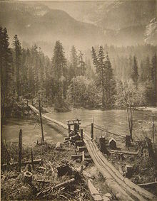 Loggers' bridge on the Skykomish (1910).
In the 1890s the Great Northern Railway was built along the Skykomish, South Fork Skykomish, and Tye Rivers, crossing the crest of the Cascades at Stevens Pass. Today the track is owned by BNSF Railway, known as the Burlington Northern Railroad from 1970-1995. Stevens Pass is named after the Great Northern surveyor John Frank Stevens. Two railroad tunnels, both called Cascade Tunnel, were built at Stevens Pass. The first one was built slightly north of the pass. It was replaced in 1929 with the New Cascade Tunnel, which at 7.8 miles (12.6 km) long was for nearly 60 years the longest railroad tunnel in North America and is still the longest in the United States.[6] The New Cascade Tunnel is a few miles south of Stevens Pass. Its western entrance is near the confluence of Tunnel Creek and the Tye River. A small amount of the water flows out of both tunnels into the Tye River. An interpretive center for the Iron Goat Trail, located at Scenic on the upper Tye River, describes the history of the area including the old railroad and new trail. The interpretive center was built near the site of one of the greatest railroad tragedies in American history, the Wellington Disaster.[7]
One of the Native American trails crossing the Cascades followed the Skykomish and North Fork Skykomish to Cady Pass.[citation needed]
Recreation
The Skykomish River is used for rafting and kayaking, especially around the Index, WA area during the summer months. The Skykomish River is mostly ranked between Class III and Class III+ rapids, depending on the circumstances and season, but includes Boulder Drop, a class IV+ rapids.
Waterfalls
North Fork
- Deer Falls
- Bear Creek Falls
South Fork
- Eagle Falls
- Canyon Falls
- Sunset Falls
See also
- List of Washington rivers
References
- ^ a b U.S. Geological Survey Geographic Names Information System: Skykomish River
- ^ a b "National Hydrography Dataset". United States Geological Survey. http://nhd.usgs.gov/index.html. Retrieved 4 September 2010. ArcExplorer GIS data viewer.
- ^ a b "Watershed Boundary Dataset". USDA, NRCS, National Cartography & Geospatial Center. http://www.ncgc.nrcs.usda.gov/products/datasets/watershed/. Retrieved 4 September 2010. ArcExplorer GIS data viewer.
- ^ Beckey, Fred (2003). Cascade Alpine Guide: Climbing and High Routes: Stevens Pass to Rainy Pass (3rd ed.). The Mountaineers. p. 23. ISBN 0-89886-423-2.
- ^ Bright, William (2004). Native American placenames of the United States. University of Oklahoma Press. p. 453. ISBN 9780806135984. http://books.google.com/books?id=5XfxzCm1qa4C&pg=PA453. Retrieved 11 April 2011.
- ^ Solomon, Brian (2005). Burlington Northern Santa Fe Railway. MBI Publishing. p. 83. ISBN 9780760321089. http://books.google.com/books?id=S2ktV7MzsE4C.
- ^ "Iron Goat Trail". Volunteers for Outdoor Washington. http://www.irongoat.org/. Retrieved 2009-07-18.
Categories:- Rivers of Washington (state)
- Landforms of King County, Washington
- Landforms of Snohomish County, Washington


Wikimedia Foundation. 2010.