- Skokomish River
-
For the similarly named river also in Washington State, see Skykomish River.
Skokomish River 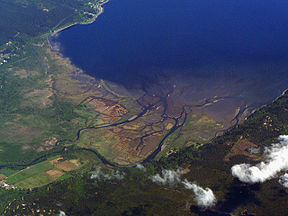
Skokomish River Delta on Hood CanalOrigin Mount Skokomish, Olympic Mountains(North Fork); Sundown Pass, Olympic Mountains (South Fork) Mouth Hood Canal Basin countries United States Length 69 km (43 mi) Mouth elevation sea level Avg. discharge 34.3 m³/s (1,212 ft³/s) Basin area 588 km² (227 mi²) The Skokomish River is a river in Mason County, Washington, United States. It is the largest river flowing into Hood Canal, an arm of Puget Sound.[1] From its source at the confluence of the North and South Forks the main stem Skokomish River is approximately 9 miles (14 km) long. The longer South Fork Skokomish River is 40 miles (64 km), making the length of the whole river via its longest tributary about 49 miles (79 km). The North Fork Skokomish River is approximately 34 miles (55 km) long.[2] A significant part of the Skokomish River's watershed is within Olympic National Forest and Olympic National Park.
Contents
Course
The Skokomish River and its two tributary forks drain the southeast corner of the Olympic Mountains, mainly in Mason County but including a portion of Jefferson County. The main stem Skokomish River is formed by the confluence of the North Fork and South Fork near small community of Mohrweis. It flows east through the broad Skokomish Valley.[3] After being crossed by U.S. Route 101 the river turns northeast. Washington State Route 106 crosses the river near its mouth on Hood Canal.[4] Near the towns of Union and Skokomish the Skokomish River enters Annas Bay[5] at the The Great Bend of Hood Canal[6] from the south, where it creates a large estuary called Skokomish Flats.[7] The lower portion of the river flows through the Skokomish Indian Reservation.[8][9]
The South Fork Skokomish River originates near Sundown Pass in Olympic National Park, near the sources of the Wynoochee River and Graves Creek, a tributary of the Quinault River. The South Fork flows southeast out of the national park and between Capitol Peak, on the west, and Wonder Mountain on the east. After receiving Rule Creek from the west the South Fork turns more directly south and enters a broader valley. It receives Church Creek from the west, then turns to flow southeast and east through a widening river valley. A number of tributary streams join the South Fork, including Pine Creek and Cedar Creek, from the south, and Le Bar Creek, Brown Creek, and Harp Creek from the north. The South Fork Skokomish leaves the main Olympic Mountains and enters flatter terrain, but flows through gorges for several miles. After exiting the gorges the South Fork turns east and enters the broad Skokomish Valley where it joins with the North Fork to form the main stem Skokomish River.[10]
The North Fork Skokomish River originates on the northern slopes of Mount Skokomish.[11] It flows west into Olympic National Park. The valley of the North Fork Skokomish is used for one of the national park's main backcountry hiking trails. At "Campground Nine Stream" the river turns south. It flows by "Campground Big Log", turns southeast and receives a number of tributaries including Four Stream and Slate Creek. The river rushes over Staircase Rapids[12] shortly upriver from Staircase Campground and the national park's Ranger Station Staircase. The Staircase area is the main entry into the southeast portion of Olympic National Park. The North Fork receives Elk Creek at the campground and Lincoln Creek shortly downstream. The river then meanders southeast into Lake Cushman, a reservoir created to supply Tacoma with electricity. The tributary Big Creek enters the lake near Lake Cushman State Park. The North Fork exits Lake Cushman's southern end and flows a short distance to another reservoir, Lake Kokanee, from which it flows south into the Skokomish Valley to join the South Fork, forming the main stem Skokomish River.[13] Lake Cushman and Lake Kokanee are maintained by Cushman Dam No. 1 and Cushman Dam No. 2 respectively.
Until recently the entire flow of the North Fork is normally diverted at Cushman Dam No. 2, except for instream flow requirements and infrequent larger releases.[14] On January 12, 2009, Tacoma Power, the Skokomish Tribe, and state and federal agencies signed settlement agreements that resolved long-standing disputes and damage claims relating to the Cushma Hydroelectric Project.[15] As part of the settlement water will be released into the North Fork Skokomish River below the dams in order to mimic natural flow.[16]
History
Prior to the construction of the Cushman Hydroelectric Project, the Skokomish River was once Washington State's largest and most productive salmon-producing river.[17]
The name "Skokomish" comes from the Twana sqʷuqʷóʔbəš, also spelled sqWuqWu'b3sH, and meaning "river people" or "people of the river".[18][19][20] The Skokomish were one of the largest of the nine different Twana village communities that existed before about 1860. By their locations, the nine groups were the Dabop, Quilcene, Dosewallips, Duckabush, Hoodsport, Skokomish, Vance Creek, Tahuya, and Duhlelap communities.[21] Within these nine communities there were at least 33 settlements.[22]
The South Fork's drainage was heavily logged, although logging has been discontinued in the Olympic National Forest since the late 1980s.
Flooding
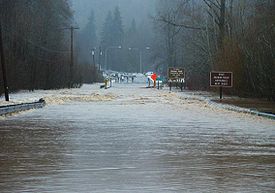 U.S. Route 101 north of Shelton flooded over by nearly four feet of floodwaters from the Skokomish River in Washington State. Photo taken December 3, 2007 at the height of the December 2007 Pacific Northwest storms.
The Skokomish is the most flood-prone river in Washington State, as it is the first river to flood during any major rain event.[23] It set an all-time record-high flood level on December 3, 2007 when an intense tropical rainstorm moved in following several inches of snow from the day prior.[24] Its maximum discharge of 29,000 cubic feet (820 m3) per second, recorded on December 3, 2007,[25] was more than twenty times its mean flow, and bested its previous record set on November 5, 1934 at more than 27,000 cubic feet (760 m3) per second. The floods completely ripped up Highway 101 through the Skokomish Valley, resulting in two-day closure while emergency repairs were made. The 2007 flood event prompted Mason County officials and the Washington Department of Transportation to design and construct a newer, elevated roadway structure over the area of Purdy Creek, which is the lowest point in elevation in the valley that Highway 101 crosses. After 16 months of planning and construction, a 350-foot bridge elevated 12 feet higher than the original roadway was opened in July, 2009.
One notable flood in 1996 closed U.S. Route 101 and State Route 106 for four days, stranding a KOMO TV news crew from Seattle. Typically, these floods on the Skokomish spawn scores of Seattle TV news crews and print journalists to the scene, and is not unheard of for stories of Skokomish River floods by the media to include the joke "Why did the salmon cross the road?" [26]
The combination of extensive clearcut logging, the damming of the North Fork, and winter-weather rain patterns are the primary reasons for the flooding that occurs almost every year on the South Fork. In late fall through early spring, storms often come from the southwest. These usually drop the most rain in the vicinity of the Skokomish River due to the topography of the Olympic Peninsula.[27] It is suspected that tectonic uplift of the land may be contributing to the unusually frequent flooding that has plagued the Skokomish, even prior any major anthropogenic disturbances.[28]
See also
References
- ^ Rose, Doug (2006). Washington River Maps & Fishing Guide. Frank Amato Publications. ISBN 1-57188-367-3.
- ^ River lengths calculated in Google Earth using GNIS coordinates.
- ^ U.S. Geological Survey Geographic Names Information System: Skokomish Valley
- ^ U.S. Geological Survey Geographic Names Information System: Skokomish River
- ^ U.S. Geological Survey Geographic Names Information System: Annas Bay
- ^ U.S. Geological Survey Geographic Names Information System: The Great Bend
- ^ U.S. Geological Survey Geographic Names Information System: Skokomish Flats
- ^ U.S. Geological Survey Geographic Names Information System: Skokomish Reservation
- ^ General course info from USGS topographic maps accessed via the "GNIS in Google Map" feature of the USGS Geographic Names Information System website.
- ^ U.S. Geological Survey Geographic Names Information System: South Fork Skokomish
- ^ U.S. Geological Survey Geographic Names Information System: Mount Skokomish
- ^ U.S. Geological Survey Geographic Names Information System: Staircase Rapids
- ^ U.S. Geological Survey Geographic Names Information System: North Fork Skokomish
- ^ "Water Resources Data-Washington Water Year 2005; Skokomish River Basins". United States Geological Survey. http://pubs.usgs.gov/wdr/2005/wdr-wa-05-1/pdf/wa00103ADR2005_Figure18.pdf. Retrieved 2009-07-09.
- ^ "TPU Power Cushman Hydro Project". Tacoma Power. http://www.mytpu.org/tacomapower/power-system/hydro-power/cushman-hydro-project/Default.htm. Retrieved 2009-07-13.
- ^ "Lake Levels and River Flows". Tacoma Power. http://www.mytpu.org/files/library/cushman-lake-levels.pdf. Retrieved 2009-07-13.
- ^ Lansing, Steve. "Skokomish: The Value of a River". Resources for Ecological Anthropology. http://www.ic.arizona.edu/~lansing/skokomish/skokintro.htm. Retrieved 2007-12-11.
- ^ Bright, William (2004). Native American Placenames of the United States. University of Oklahoma Press. p. 452. ISBN 9780806135984. http://books.google.com/books?id=5XfxzCm1qa4C&pg=PA452. Retrieved 3 November 2010.
- ^ Wray, Jacilee (2003). "Skokomish: Twana Descendants". Native Peoples of the Olympic Peninsula: Who We Are. University of Oklahoma Press. p. 65. ISBN 9780806135526. http://books.google.com/books?id=ustxjL5p-y4C&pg=PA65. Retrieved 3 November 2010.
- ^ http://hood.hctc.com/~skok1/ The Skokomish Tribal Nation
- ^ Elmendorf, William Welcome (1993). Twana narratives: native historical accounts of a Coast Salish culture. UBC Press. p. xxix. ISBN 9780774804752. http://books.google.com/books?id=RR1muiH0ZzUC&pg=PR29. Retrieved 3 November 2010. See also map on page 2
- ^ Wray, Jacilee (2003). Native Peoples of the Olympic Peninsula: Who We Are. University of Oklahoma Press. p. 67. ISBN 9780806135526. http://books.google.com/books?id=ustxjL5p-y4C&pg=PA67. Retrieved 3 November 2010.
- ^ "An Overview of Washington's Skokomish River". The Wilderness Society. http://www.wilderness.org/Library/Magazine/winter20052006/reg-pacificnorthwest.cfm. Retrieved 2007-12-11.. See also, "Skokomish Watershed Action Team". Red Lodge Clearinghouse Story Profiles. November 2006. Archived from the original on 2007-09-28. http://web.archive.org/web/20070928070027/http://www.redlodgeclearinghouse.org/stories/skokomishwatershed.html. Retrieved 2007-12-11.
- ^ "Flood waters recede, revealing devastating loss". KOMOTV.com. 2007-12-06. http://www.komotv.com/news/12207451.html. Retrieved 2007-12-11.
- ^ "USGS 12061500 SKOKOMISH RIVER NEAR POTLATCH, WA". USGS National Water Information System: Web Interface. 2007-12-06. http://waterdata.usgs.gov/wa/nwis/uv?cb_00060=on&cb_00065=on&format=html&period=10&site_no=12061500. Retrieved 2007-12-11.
- ^ Soltes, Harley (2001-11-16). "Why did the salmon cross the road?". The Seattle Times. http://seattletimes.nwsource.com/news/local/links/salmon_reprint.html. Retrieved 2007-12-11.
- ^ McBee, Dave. "Flooded by Greed". "Get Lost" magazine. http://www.getlostmagazine.com/features/1999/9906skok/skok.html. Retrieved 2007-12-11.
- ^ Polenz, M.; Contreras, T. A.; Czajkowski, J. L.; Legorreta Paulin, G.; Miller, B. A.; Martin, M. E.; Walsh, T. J.; Logan, R. L.; Carson, R. J.; Johnson, C. N.; Skov, R. H.; Mahan, S. A.; Cohan, C. R., (June 2010). "Supplement to Geologic Maps of the Lilliwaup, Skokomish Valley, and Union 7.5-minute Quadrangles, Mason County, Washington— Geologic Setting and Development Around the Great Bend of Hood Canal". Washington Division of Geology and Earth Resources Open-File Report 2010-5: 23. http://www.dnr.wa.gov/Publications/ger_ofr2010-5_lilliwaup_skokomish_valley_union_suppl_24k.pdf.
External links
Categories:- Rivers of Washington (state)
- Landforms of Mason County, Washington


Wikimedia Foundation. 2010.