- Market Lavington
-
Coordinates: 51°17′00″N 1°59′00″W / 51.2833°N 1.9833°W
Market Lavington 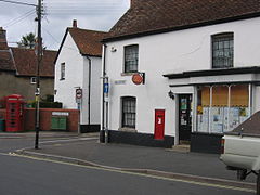
Village centre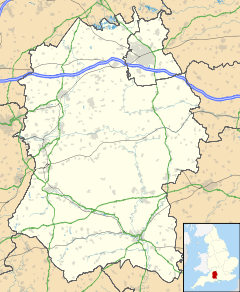
 Market Lavington
Market Lavington shown within WiltshirePopulation 2,257 (2001 census) OS grid reference SU014541 Unitary authority Wiltshire Ceremonial county Wiltshire Region South West Country England Sovereign state United Kingdom Post town DEVIZES Postcode district SN10 Dialling code 01380 Police Wiltshire Fire Wiltshire Ambulance Great Western EU Parliament South West England UK Parliament Devizes List of places: UK • England • Wiltshire Market Lavington is a large village with a population of about 2,300 on the northern edge of Salisbury Plain in Wiltshire, England, near the market town of Devizes.
Contents
Status
Market Lavington was formerly considered to be a town and received a Royal Charter to hold a weekly market in the year 1254.
Even today it still has a Co-op supermarket, a pharmacist, a butcher, a newsagent's shop, a post office, two hairdressers, two [[public house|pubs],a lovely Indian Take Away with open kitchen and other small businesses. There is also a Nursing and Residential Home. The manor house is now the junior boarding house for Dauntsey's School
As well as having its own elected parish council, Market Lavington falls within the area of the Wiltshire Council unitary authority, which is responsible for all significant local government functions.
Schools
The village has two schools, as well as a pre-school group. It is less than two miles from Dauntsey's School, in nearby West Lavington.
- St. Barnabas's primary school
- Lavington School, a comprehensive, specialist [[Maths and Computing College.
Events
Market Lavington hosts an annual barrel rolling contest and a tug of war on White Street [1], leading up Lavington Hill.
See also
Further reading
- Crittall, Elizabeth (ed.); Baggs, A. P.; Crowley, D. A.; Pugh, Ralph B.; Tomlinson, Margaret (1975). Victoria County History: A History of the County of Wiltshire, Volume 10: Swanborough hundred; the borough of Devizes.
- Pevsner, Nikolaus; Cherry, Bridget (revision) (1975). The Buildings of England: Wiltshire. Harmondsworth: Penguin Books. ISBN 0 14 0710.26 4.
External links
- Village Website: MarketLavington.org.uk
- The Lavingtons Online
- Historic Market Lavington photos at BBC Wiltshire
- Brief history of the village
- Market Lavington museum website
Ceremonial county of Wiltshire Unitary authorities Swindon • Wiltshire CouncilMajor settlements Amesbury • Bradford on Avon • Calne • Chippenham • Corsham • Cricklade • Devizes • Highworth • Larkhill • Ludgershall • Malmesbury • Marlborough • Mere • Melksham • Royal Wootton Bassett • Salisbury • Swindon • Tidworth • Tisbury • Trowbridge • Warminster • Westbury • Wilton
See also: List of civil parishes in WiltshireRivers Topics Flag • Grade I listed buildings • History • Lords Lieutenant • Deputy Lieutenants • High Sheriffs • Parliamentary constituencies • Local elections • Places • MuseumsCategories:- Villages in Wiltshire
- Wiltshire geography stubs


Wikimedia Foundation. 2010.