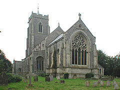
- Martham
-
Coordinates: 52°42′30″N 1°37′58″E / 52.70844°N 1.63282°E
Martham 
St Mary, Martham
 Martham shown within Norfolk
Area 11.84 km2 (4.57 sq mi) Population 3,216 - Density 272 /km2 (700 /sq mi) OS grid reference TG455185 Parish Martham District Great Yarmouth Shire county Norfolk Region East Country England Sovereign state United Kingdom Post town GREAT YARMOUTH Postcode district NR29 Police Norfolk Fire Norfolk Ambulance East of England EU Parliament East of England List of places: UK • England • Norfolk Martham is a village and civil parish in the English county of Norfolk and within the Broads National Park. It is situated some 15 km (9.3 mi) north-west of the town of Great Yarmouth and 30 km (19 mi) north-east of the city of Norwich.[1]
The civil parish has an area of 11.84 km2 (4.57 sq mi) and in the 2001 census had a population of 3,126 in 1,267 households. For the purposes of local government, the parish falls within the district of Great Yarmouth. In recent years the population has expanded with considerable building of new housing. There is a good bus service to Great Yarmouth.[2] There was formerly a Martham railway station, but this closed in 1959.
The village has several Georgian houses, a large green and duck pond. Near the church, a lane leads to the former location of Martham Ferry across the River Thurne. The ferry no longer exists, but has been replaced by a swing bridge, which can only be crossed by the public on special occasions.[3] About 2 km (1.2 mi) to the north of the village is Martham Broad, a 140 acres (57 ha) nature reserve.
The Saxons settled in Martham around AD600 and gave the village its name, "the ham of the martens", the home of the polecats.[4]
Notes
- ^ Ordnance Survey (2005). OS Explorer Map OL40 - The Broads. ISBN 0-319-23769-9.
- ^ Office for National Statistics & Norfolk County Council (2001). Census population and household counts for unparished urban areas and all parishes. Retrieved December 2, 2005.
- ^ "Highham Holmes open day". Broads Authority. http://www.broads-authority.gov.uk/news/events/event-details.html?id=4142. Retrieved 2011-08-29.
- ^ http://www.martham.gov.uk/History/history.htm
External links
- Map sources for Martham.
- Information from Genuki Norfolk on Martham.
- Martham Parish Council website
- Martham Local Weather website
Ashby with Oby · Belton with Browston · Bradwell · Burgh Castle · Caister-on-Sea · Filby · Fleggburgh · Fritton and St Olaves · Hemsby · Hopton-on-Sea · Martham · Mautby · Ormesby St Margaret with Scratby · Ormesby St Michael · Repps with Bastwick · Rollesby · Somerton · Stokesby with Herringby · Thurne · West Caister · Winterton-on-Sea
See also: South Norfolk · Great Yarmouth · Broadland · North Norfolk · King's Lynn and West Norfolk · Breckland Categories:- Villages in Norfolk
- Civil parishes in Norfolk
- Norfolk geography stubs
Wikimedia Foundation. 2010.

