- Marin Headlands
-
 The Marin Headlands, as seen from the Golden Gate Bridge.
The Marin Headlands is a hilly area at the southernmost end of Marin County, California, just north of the Golden Gate Bridge. The Headlands are located just north of San Francisco, immediately across the Golden Gate Bridge. The entire area is part of the Golden Gate National Recreation Area. The Headlands are famous for their stunning views of the Bay Area, especially the Golden Gate Bridge.
Contents
Natural history
Climate
The Headlands sometimes create their own clouds when moist, warm Pacific Ocean breezes are pushed into higher, colder air, causing condensation, fog, fog drip and perhaps rain. The hills also get more precipitation than at sea level, due to the same reason. However, despite being relatively wet, strong gusty Pacific winds prevent dense forests from forming. The many gaps, ridges, and valleys in the hills increase the wind speed and periodically, during powerful winter storms, these winds can reach hurricane force.[citation needed] In summer, breezes can still be very gusty, when the oceanic air and fog cross the hills.
November through February in the Headlands are dominated by periodic rainstorms that blow in from the Pacific, often originating in the Gulf of Alaska, and give the area the majority of its rainfall for the year. These cloudy, gray, and rainy days often are interspersed with cool but extremely clear ones. As winter turns to spring, the April-to-June weather tends to be dominated by powerful winds, less rain, and clearer skies. Summer days alternate between clear and warm intervals, giving way to foggy and cool periods. September and October bring the highest average temperatures of the year and the longest stretches of clear skies.[1]
Hawk Hill
Main article: Hawk Hill, CaliforniaThe centerpoint of the Marin Headlands skyline is the 920-foot (280 m) Hawk Hill, the lookout point for the largest known flight of diurnal raptors in the Pacific states.
Each autumn, from August into December, tens of thousands of hawks, kites, falcons, eagles, vultures, osprey, and harriers are funneled by the peninsular shape of Marin County into the headlands. Hawks avoid flight over water since warm thermals that provide lift are rare. Abundant populations of small mammals protected by the park are one resource that helps maintain the large number of visiting raptors in the Headlands during the fall, but the strong onshore winds hitting the hills of the Headlands provide cold updrafts and hot late summer days provide warm thermals that allow these birds to fly more efficiently.
Volunteers with the Golden Gate Raptor Observatory count and track this fall migration using bird-banding and radio-tracking techniques, all in cooperation with the National Park Service.
Other Wildlife
The Marin Headlands are also home to large populations of deer, bobcats, coyotes, rabbits, raccoons, and skunks. River Otters inhabit the freshwater lagoons and streams. Large numbers of water birds also migrate through the Headlands, including Brown Pelicans from May through October, grebes, egrets, and Great Blue Herons in the spring, summer, and fall. The Headlands' status as a park protects the habitat and populations of these animals within just a few miles of San Francisco and its suburbs.
In the waters surrounding the Headlands, Harbor Seals can be found year-round, Grey Whales can be seen in the spring and fall, and seabirds such as Common Murres and Surf Scoters swim within sight of shore.
Geology
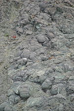
The Marin Headlands are a fascinating geological formation created by the accretion of oceanic sediments onto the North American Plate from the Pacific Plate. The primary components of Headlands geology include graywacke sandstone, radiolarian chert, serpentinite, pillow basalts, and shale. These rocks began their migration over one hundred million years ago from as far south as what today we call "Los Angeles". The erosion of the hillsides and construction activities during the military era have exposed some dramatic examples of these rock types for easy viewing, and the folding caused by tectonic action is visually evident in many places throughout the Headlands.[2]
Cultural history
Native Americans
The Marin Headlands were home to the Native American Coastal Miwok tribe, who moved between the bay side of the peninsula and the ocean side seasonally, for thousands of years.
Ranchos
In the 18th century, Spanish and Mexican ranchers occupied the Headlands, eventually giving way to Portuguese immigrant dairy farmers (often from the Azores) during the American period following the U.S. acquisition of California in the Mexican-American War.
Military sites
The Marin Headlands is the site of a number of historic military settlements fortifications, including Fort Cronkhite, Fort Barry, a large number of bunkers and batteries, and the SF-88 Nike Missile silo. From the 1890s, the first military installations were built to prevent hostile ships from entering San Francisco Bay. The batteries at Kirby Cove, above Black Sands Beach, south of Rodeo Beach, and at Battery Mendell are examples of fortifications from the pre-World War I period. During World War II Batteries Wallace, Townsley, and 129 on Hawk Hill were built into the hills to protect them from aerial bombardment and the high caliber shells that would be fired by Axis battleships. The emplacements at the top of Hawk Hill were used for a radio station. During the Cold War, the gun batteries were decommissioned, but antiaircraft missile sites were built on the northern and southern sides of Rodeo Lagoon. Radar sites were placed atop Hawk Hill and Hill 88. At several locations, shelters were built into the hillsides to protect the military personnel from the use of nuclear, biological, or chemical weapons.[3]
Observation posts known as base end stations can also be found in the Headlands. A well-preserved example can be seen near the northern end of Rodeo Beach, and others are located near the Point Bonita Lighthouse and on Wolf Ridge as it slopes down to the sea.
All military sites in the Headlands are now decommissioned and returned to civilian use. Some military facilities, such as SF-88, have been preserved as historical sites. Many historical buildings are now used by non-profit organizations, but maintained in their historical condition.
Other historic landmarks in the Headlands include Point Bonita Lighthouse.
Development
In the 1960s, the government sold over 2,000 acres (8 km2) of land in the Marin Headlands to a private developer who planned to build a city named Marincello. The development would house 30,000 people amongst 50 apartment towers, vast tracts of single-family homes, and a hotel along the headlands pristine shoreline and hills. In 1970, the developer lost a lawsuit claiming the land was illegally zoned. The thousands of acres that would have been developed was sold to the Golden Gate National Recreation Area allowing the open space to stay intact as a park.[4]
Recreation
Views
The Headlands afford spectacular views of San Francisco and, as such, is a very popular tourist attraction. One of the most common photographs of San Francisco is the view of the city from the Headlands with the towers of the Golden Gate Bridge just reaching out of the fog. On clear days, the site affords a panoramic view of this entire region of the bay including the Farallon Islands, Angel Island, Alcatraz, the San Francisco – Oakland Bay Bridge, the Golden Gate Bridge and the East Bay.
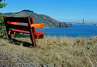
Where Conzelman Road winds along the southern shore of the Headlands and becomes one-way, a pedestrian path leads upwards to Hawk Hill. Just up a short distance on the right, nestled in a grove of Monterey Pines, is a bench situated just right to watch the Golden Gate, ship traffic beneath the bridge, and the city just beyond.
Beaches
The Headlands offers a number of beaches including Rodeo Beach (a pebble-covered, dark sand beach,) Kirby Cove, Pirates' Cove, Tennessee Beach, Muir Beach, and Muir Beach Overlook. Further north, just outside Marin Headlands, is Stinson Beach.
Hiking/Biking
There are many miles of excellent hiking and biking trails in the Headlands, encompassing passage through coastal sage scrub, chaparral, and riparian areas.
Birding
The raptor migration attracts many birdwatchers to Hawk Hill, and waterfowl and seabirds can often be seen on Rodeo Lagoon.
Facilities and notable places
The National Park Service maintains a Visitor Center near the intersection of Field Road and Bunker Road about a mile from Rodeo Beach. The Visitor Center is open daily from 9:30 AM to 4:30 PM, and contains historical and natural history displays as well as a small bookstore/gift shop. Hiking maps and Park Service program information are available as well.
Facilities include Presidio Fire Department Fire Station No.2, located at building 1045 Fort Cronkhite. This Fire Station is operated by the National Park Service and houses one fire engine with cliff rescue capabilities. Emergency services are available 24 hours per day.
Public restrooms are available in the Headlands at the Visitor Center parking lot, the parking lot near Rodeo Beach, and portable toilet facilities are available at the trailhead leading to the Point Bonita Lighthouse, along Conzelman Road near Black Sands Beach, at Battery Alexander dug into the hillside between Rodeo Beach and the Lighthouse, and at Battery 129 on Hawk Hill.
Conference center facilities are located in former military buildings maintained by the Point Bonita YMCA, the Headlands Institute, and the Headlands Center for the Arts. Cavallo Point conference center is in East Fort Baker on the eastern side of the peninsula.
Other notable areas within Marin Headlands include Kirby Cove, Rodeo Lagoon, and Tennessee Valley.
Various nonprofit organizations have facilities in Marin Headlands. These include the Marine Mammal Center, the Foundation for Deep Ecology, and the Headlands Institute, all in Fort Cronkhite, the Headlands Center for the Arts and the Marin Headlands Hostel at Fort Barry, and the Marin Headlands and Tennessee Valley Native Plant Nurseries.
See also
References
- ^ Sausalito Weather - California - Average Temperatures and Rainfall
- ^ Marin Headlands
- ^ The Marin Headlands
- ^ "Saved by Grit and Grace: Wild Legacy of the Marin Headlands" by John Hart, Bay Nature, July-September 2003
External links
- Official NPS website
- SFGate: Marin Headlands
- Bay Area Hiker: Marin Headlands
- Headlands Center for the Arts
- Marin Headlands/Fort Baker Map
- Headlands Institute
- The Marine Mammal Center
- "Head for the hills: Marin Headlands offer an inviting getaway just a bridge away from the city" by Peter Stack, San Francisco Chronicle, July 26, 2001.
- Marin Headlands from Lands End, comparing with old photography
- Geology of the Golden Gate Headlands
Coordinates: 37°49′40″N 122°30′22″W / 37.82778°N 122.50611°W
Categories:- Landforms of Marin County, California
- Golden Gate National Recreation Area
- Headlands of California
- Landforms of the San Francisco Bay Area
- Peninsulas of California
- Visitor attractions in Marin County, California
Wikimedia Foundation. 2010.


