- Mamberamo
-
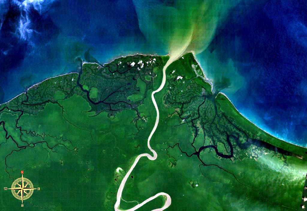
Mamberamo River 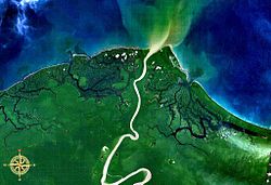 Mamberamo entering the sea, seen from space.
Country Indonesia Region Papua Source confluence of Tariku and Taritatu - coordinates 2°55′30″S 138°26′30″E / 2.925°S 138.44167°E Mouth - location Pacific - coordinates 1°28′S 137°54′E / 1.467°S 137.9°E The Mamberamo is a large river on the island of New Guinea, in the Indonesian province of Papua. It is the widest river in Indonesia.
The source of the river is formed from the confluences of its upper tributaries, the Tariku and Taritatu Rivers. From there it flows northwards in a great valley through the Van Rees Range (Pegunungan Van Rees), to reach the lowland marshes of its broad river delta. The Mamberamo discharges into the Pacific Ocean at the northern point of Point D'Urville (Tanjung D'Urville).
The river's huge valley is home to various uncontacted peoples and incredible biodiversity. In the 1990s, the Indonesian Government had plans to construct a large hydroelectric dam on the Mamberamo that would have submerged much of the area. This plan was shelved after the Indonesian financial crisis from 1998–1999, but there are concerns by environmental groups that it could be resurrected sometime in the future.
The Mamberamo area also broadly refers to several nearby mountain ranges, including the Van Rees and Foja Mountains (also known as Foya), which were the subject of a recent rapid biological assessment conducted by Conservation International, the Indonesian Institute of Sciences, and Cenderawasih University. The scientific team discovered the first new bird species from New Guinea in 60 years, and a wealth of other new plants and animals. The Foya Mountains appear to be a globally outstanding repository of biodiversity.
History
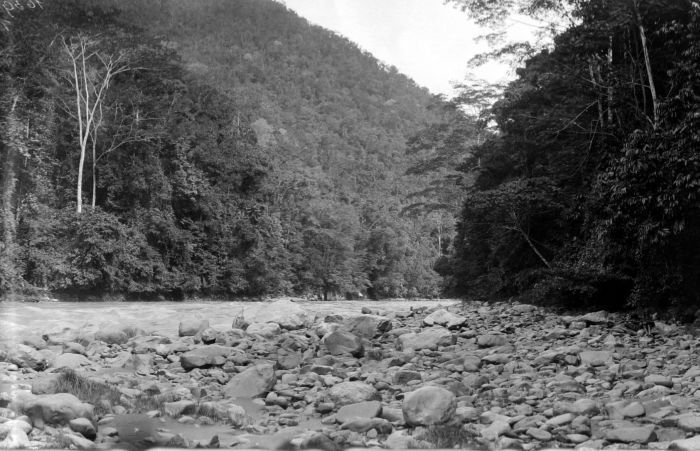
 The upper Mamberamo River photographed during the Central-North New Guinea Expedition led by Le Roux
In 1545, the Spanish navigator Yñigo Ortiz de Retez sailed along the northern coastline of the island as far as the mouth of this river. At this spot he claimed the territory for the Spanish Crown, and in the process bestowing the name to the island (Nueva Guinea) by which it is known today.
The first European to enter the mouth of the Mamberamo was Dutchman Dr D. F. van Braam Morris in 1883. The resident doctor from the northern Moluccas rowed up the river to ascertain that it was navigable by steamer.[1] The following year in 1884 van Bram Morris returned in the steamship Harvik and travelled 50 mi (80 km) along its course.[2]
References
- Souter, Gavin (1963). New Guinea: The Last Unknown. Angus & Robertson. ISBN 0-207-94627-2.
Java Bengawan Solo River · Brantas River · Cidurian River · Cikandang River · Cilaki River · Ciliwung River · Cimandiri River · Cimanuk River · Cisadane River · Cisanggarung River · Citanduy River · Citarum River · Ciujung River · Ciwulan River · Kalimalang River · Kali Bodri River · Kali Opak River · Kali Pemali River · Kali Sanen River · Kali Serang River · Porong River · Progo River · Serayu River · Widas RiverKalimantan Arut River · Barito River · Kahayan River · Kapuas River · Kapuas (Barito) River · Katingan River · Kayan River · Lamandau River · Landak River · Lawa River · Mahakam River · Melawi River · Mendawai River · Pawan River · Sambas River · Sampit River · Sekayam River · Sesayap River · Wain RiverSulawesi Bongka River · Jeneberang River · Kalaena River · Karama River · Lalindu River · Lariang River · Lasolo River · Mamasa River · Manado River · Marisa River · Paguyaman River · Palu River · Pangkajene River · Poso River · Sadang River · Sampara River · Tallo River · Walanae RiverLesser Sunda Islands Ayung River · Benain River · Kadassa River · Kadumbul River · Melolo River · Mina River · Moyo River · Noel Besi River · Polapare River · Pono River · Sissa River · Sungi River · Wera RiverMaluku and Papua Bian River · Bien River · Bulaka River · Digul River · Kampung River · Kamundan River · Kumbe River · Lorentz River · Mamberamo River · Mapi River · Maro River · Mimika River · Momats River · Muturi River · Pulau River · Seremuk River · Sobger River · Songgato River · Tabai River · Tariku River · Taritatu River · Van Daalen River · Vriendschaps River · Wamma River · Wapoga River · Warenai River · Waruta River · Wiriagar RiverCategories:- Rivers of West Papua
Wikimedia Foundation. 2010.