- Narara, New South Wales
-
"Narara" redirects here. For the ship, see Narara (ship).
Narara
Central Coast, New South Wales
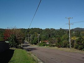
Looking down Deane Street, Narara's "Main Street", towards the railway stationPopulation: 7,791 (2006 census) Postcode: 2250 Area: 5.9 km² (2.3 sq mi) Location: 4 km (2 mi) N of Gosford LGA: City of Gosford Parish: Gosford State District: The Entrance Federal Division: Dobell, Robertson Suburbs around Narara: Somersby Niagara Park Niagara Park Somersby Narara Wyoming West Gosford Gosford North Gosford Narara
 i/nəˈrærə/ is a suburb of the Central Coast region of New South Wales, Australia, located 4 kilometres (2 mi) north of Gosford's central business district. It is part of the City of Gosford local government area.
The suburb is mostly residential but also holds Narara railway station on the Newcastle and Central Coast railway line. It also contains a corner shop and bottleshop, a number of parks, sporting grounds, and a concrete public skatepark. It is the home of Narara Valley High School, a NSW government public high school, and St Philips Christian College Gosford (formally Gosford Christian College), a private Christian institution educating from kindergarten to year twelve.
The name 'Narara' can be traced back to the local Aboriginal term for 'black snake', which appears on the official emblem of Narara Valley High School and the scarf of 1st Narara Scout Group.[1][2]
Narara's claim to fame is that the Narara Music Festival was held nearby in Somersby in 1983 and 1984. The Angels, an Australian rock band, produced an 11 track live album recorded at the festival named, appropriately enough, "Live at Narara".
Narara largely consisted of orchards and small mixed farms. Water from the small dams that used to be accessible from Narara Creek Road was piped in wooden piping across Narara Creek to the Railway station to supply steam trains. The dams were also a popular swimming spot especially when the ladder and walkway still existed on the lower dam wall.
References
- ^ Gosford City Library. "Placenames". http://www.gosford.nsw.gov.au/library/local_history/placenames.html. Retrieved 2007-07-21.
- ^ "Narara Valley Primary School". http://www.nararavaly-h.schools.nsw.edu.au/. Retrieved 2007-07-22.
External links
Coordinates: 33°23′53″S 151°21′04″E / 33.398°S 151.351°E
Categories:- Suburbs of Central Coast, New South Wales
- Central Coast, New South Wales geography stubs
Wikimedia Foundation. 2010.
