- East Gosford, New South Wales
Infobox Australian Place | type = suburb
name = East Gosford
city = Central Coast
state = nsw
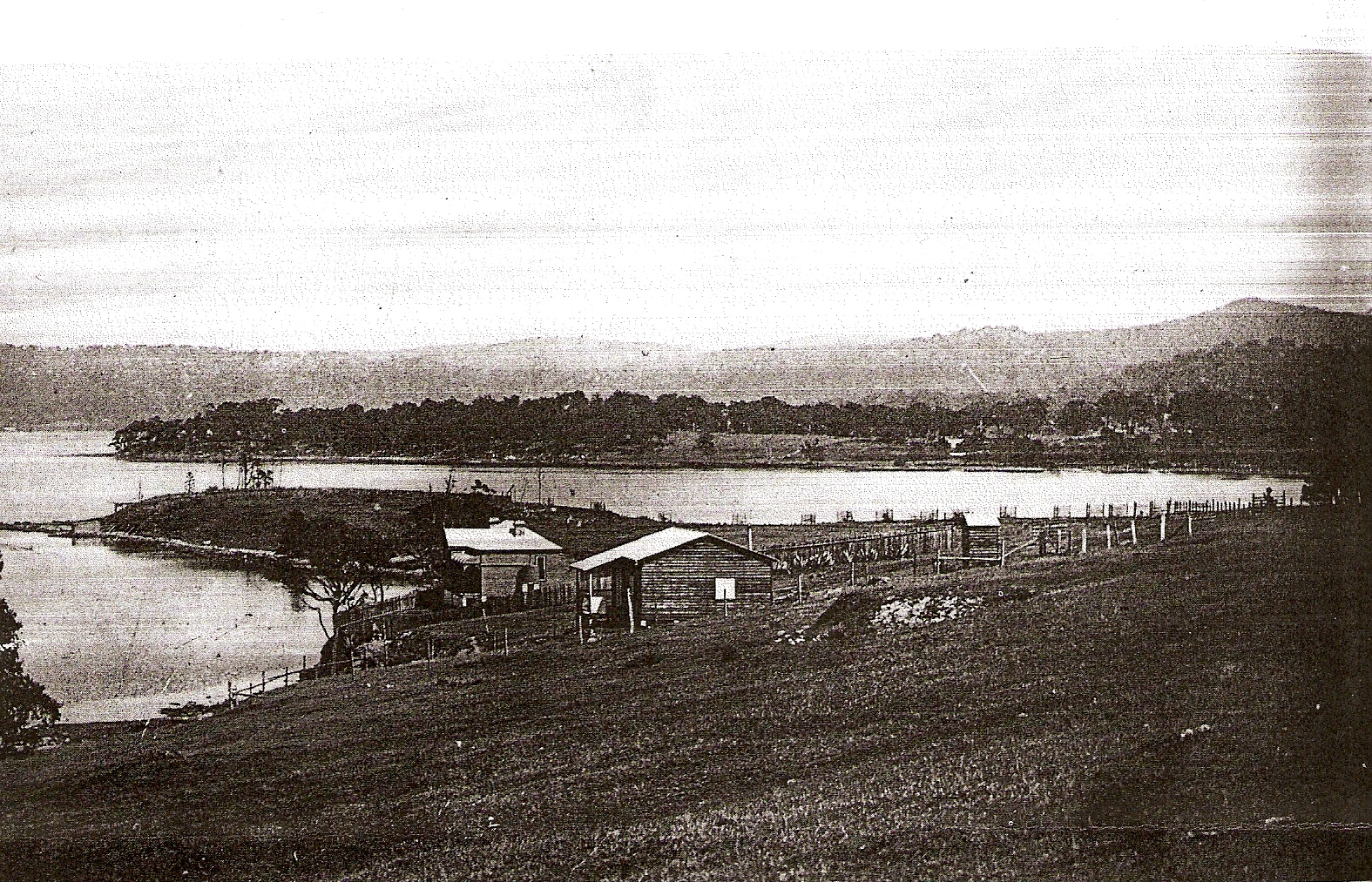
caption = A photograph of Peeks Point in 1921. Caroline Bay and Point Frederick are in the background.
lga = City of Gosford
postcode = 2250
pop = 3,514 (2006 census)Census 2006 AUS|id=SSC13111|name=East Gosford (State Suburb)|accessdate=2007-07-21]
area = 2.1
est = 1991Ref_label|A|a|nonecite web | title=Geographical Names Register Extract: East Gosford | work=Geographical Names Board of New South Wales | url=http://www.gnb.nsw.gov.au/name_search/extract?id=KWKqwpKmuj | accessdate=2007-02-21]
parish = Gosford
stategov = Gosford
fedgov = Robertson
dist1 = 2
dir1 = SE
location1= Gosford
dist2 = 75
dir2 = N
location2=Sydney
near-nw = Gosford
near-n = North Gosford
near-ne = Springfield
near-w = Gosford
near-e = Erina
near-sw = Point Frederick
near-s = "Brisbane Water "
near-se = "Brisbane Water "East Gosford is a suburb of the Central Coast region of
New South Wales ,Australia , located immediately southeast of Gosford'scentral business district . It is part of theCity of Gosford local government area, and occupies an area previously inhabited by theDarkinjung people .East Gosford is named after the
Archibald Acheson, 2nd Earl of Gosford , with whom New South Wales GovernorGeorge Gipps served inCanada . Archibald Acheson was appointed Governor of British North America in 1835, and conducted a royal commission into thestate of affairs inLower Canada .cite web | title=Gosford City Council: Placenames | work=Gosford City Council | url=http://www.gosford.nsw.gov.au/library/local_history/placenames.html | accessdate=2007-02-25]At the ABS 2006 census, East Gosford had a population of 3,514 people.Census 2006 AUS|id=SSC13111|name=East Gosford (State Suburb)|accessdate=2007-07-21] This was an increase of 182 people from the 2001 censusCensus 2001 AUS|id=SSC15091|name=East Gosford (State Suburb)|accessdate=2007-08-23] and an increase of 370 people from the 1996 census.cite web | title=Central Coast Social Atlas | work=Wyong Shire Council & Gosford City Council | url=http://www.wyongsc.nsw.gov.au/wyongshire/social_atlas/Appendix_A.pdf| accessdate=2007-08-23] East Gosford residents have a median age of 46 years, compared to the Central Coast average of 40.Census 2001 AUS|id=10570|name=Gosford-Wyong (Statistical Subdivision)|accessdate=2007-08-23] Median incomes in East Gosford were above the region-$422 compared with $407.
History
The site where East Gosford now stands changed hands twice before being sold to Samuel Peek, a Sydney tea merchant. East Gosford was surveyed in 1841 and within a year, began to develop, when Peek began to sell land there. A
wharf and several shops were built.cite web | title=Mann Street South Heritage Walk | work=Gosford City Council | url=http://www.gosford.nsw.gov.au/library/local_history/heritage.html | accessdate=2007-04-24] After building a three story hotel, Peek and his family went toEngland in 1850. Returning in 1857, their ship wrecked near the Gap, and all family members perished. Many of his private papers were lost in the wreck, and he left no heirs, so many of his buildings decayed with bricks, doors and woodwork disappearing.Swancott, 1984, p5]In 1858 a small sandstone church was built and was centrally located for parishioners from Erina, Gosford and Terrigal. However when the railway was opened, more people began to live closer to Gosford. The church became unused and so it was decided to move the church, stone-by-stone to Mann Street, Gosford where it is still located.cite web | title=Mann Street South Heritage Walk | work=Gosford City Council | url=http://www.gosford.nsw.gov.au/library/local_history/heritage.html | accessdate=2007-04-24]
Located on the eastern border of East Gosford is Erina Creek. Originally the creek provided access to the many
ketch es and steamers which came in and out on timber business. A man operating a punt carried people and their goods across Erina Creek. In 1884 the Government called tenders for the construction of aniron drawbridge with timber approahes. On September 15, the tender of John Johnstone was accepted and work began. The bridge was completed in 1886, probably early in the year, at a cost of ₤3,695/15/-, which was considerably more than the average cost of £500 for country bridges. Part of the bridge rolled back towards the Gosford side by means of wheels guided on rails. This was achieved by men cranking the mechanism by hand. The bridge was opened seven times a day. The last of the steamers to go through was the "Lone Pine" in 1928.Dundon, 1980, p84] The old Punt Bridge, as it was called, was replaced by a modern bridge built by Beattie and Frost Pty Ltd of Gosford in 1962.Dundon, 1980, p85] It is still known as The Punt Bridge and forms part of theCentral Coast Highway .In 1913 two sisters, the Misses Marion and Aileen Macabe, opened a school for girls at "Boomera", later known as Hinemoa Private Hospital in Masons Parade, Gosford. Some years later the expanded
school was moved into "Mona Vale" built by William Rogers. Completed in 1889, this residence now forms part of St. Edward's College. The property on which "Mona Vale" was built was part of an original Unit area|acre|20|0 crown grant to surveyor William Shone in 1844. Subsequent owners were Charles Venteman, James Harrison and William Tyrrell, Bishop of Newcastle. It was Tyrrell's death in 1879 which led to the subdivision and public auction of the property. A portion was bought by William Rogers for £490. He demolished an earlier house on the land when he built "Mona Vale".Dundon, 1980, p92] The school took boarders and day students (the latter included a few small boys), and offered a very wide range of subjects. Extras such asEsperanto ,elocution , dancing andmusic could be undertaken and popular sports wereswimming , rowing andtennis . Gosford livery stable owner Mr Sam Ranyard assisted Miss Aileen Maccabe in giving horse-riding instructions and also suppliedhorse s. In 1923 the MacCabe sisters were faced with overcrowding problems and moved their school to Lindfield, where it was known as "Marshall Mount".Dundon, 1980, p93]Negotiations began in 1951 between the Christian Brothers and Mr W. Rogers for the purchase of "Mona Vale" and adjacent land. St. Edward's College construction started in 1952 and "Mona Vale" was restored. In the 1970s the old house again underwent restoration and was used as a staffroom and administration centre for the college until 2005.Dundon, 1980, p93]
There are currently four schools in East Gosford. St. Patricks, a
Catholic school and Gosford East Public School both cater for boys and girls from kindergarten to year six.cite web | title=St Patricks Catholic Primary School | work=St Patricks Catholic Primary School | url=http://www.stpatseastgosford.dbb.catholic.edu.au/ | accessdate=2007-08-08] cite web | title=GEPS Home Page | work=Gosford East Public School | url=http://www.gosfordest-p.schools.nsw.edu.au/ | accessdate=2007-08-08] St. Edwards is a Catholic boys school and St. Josephs is a Catholic girls school, both of which cater for students from year seven to year twelve.cite web | title=St. Edward's College | work=St. Edward's College | url=http://www.stedwards.nsw.edu.au/ | accessdate=2007-08-08] cite web | title=Secondary Schools - Catholic Schools Office - Diocese of Broken Bay | work=Broken Bay Catholic Diocese | url=http://www.cso.brokenbay.catholic.edu.au/schools/secondary.html | accessdate=2007-08-08]Gosford Regional Gallery and Gosford/Edogawa Commemorative Garden are located in East Gosford. The Commemorative Garden is a
Japanese garden that was built as agift to residents of Gosford City Council by the Ward of Edogawa,Tokyo ,Japan . They were opened in September 1994.cite web | title=Gosford Regional Gallery: Gosford/Edogawa Commemorative Garden | work=Gosford City Council | url=http://www.gosfordregionalgallery.com/garden.htm | accessdate=2007-04-21]In the past East Gosford had branches for all four major banks, however these had been progressively closed by 2000. As a result the Chamber of Commerce sought to open a
Bendigo Bank Community branch. The branch was opened on5 August ,2000 .cite web | title=Bendigo Bank: East Gosford and Districts Community Bank | work=Bendigo Bank | url=http://www.bendigobank.com.au/public/community_bank/community_bank.asp?name=east_gosford | accessdate=2007-04-25] The branch has been credited with a turnaround in retail trading in East Gosford. The East Gosford Community Bank has now expanded and operates a second branch at Lisarow and an agency at Kincumber.cite news | last = Adams | first = Edgar | title = Community Bank upgrades, expands | work = Central Coast Business Review | pages = 7 | publisher = Adams Business Publications Pty Ltd | date = 2006-04-01]In 2004 a Pedestrian Bridge over York Street was opened to make it safer for children at East Gosford's four schools to cross.cite news | title = Bridge is a step nearer | pages = 20 | publisher = Central Coast Express Advocate | date = 2004-10-06 ] The road was identified in 2002 as the section most in need of a bridge in 2002 in a
Roads and Traffic Authority report.cite web | title=Council Meeting 02.04.2002 - Engineering Operations | work=Gosford City Council | url=http://www.gosford.nsw.gov.au/council/council_meetings/agenda_reports/2002/04/02/engineering_operations.pdf| accessdate=2007-09-18] The bridge cost $2.5 million to build and included two lifts for disabled access. It is funded by advertising on roadside panels throughout the Gosford local government area.cite news | title = Brooks opposes `unsightly' bridge | pages = 16 | publisher = Central Coast Express Advocate | date = 2002-07-10 ] The Government was criticised during construction as the opening appeared to be delayed so that it could be opened by the local state member.cite news | title = Bridge kept closed | pages = 8 | publisher = The Daily Telegraph | date = 2004-12-13 ] OnAugust 9 2006 the main road through East Gosford was designated the Central Coast Highway to guide motorists unfamiliar with the region.cite web | title=Central Coast Highway - Kariong to Doyalson | work=Roads and Traffic Authority | url=http://www.rta.nsw.gov.au/constructionmaintenance/majorconstructionprojectsregional/centralcoast/kariong-doyalson.html| accessdate=2008-01-03]Politics
Notes
- Note_label|A|a|none1991 refers to the year East Gosford was officially recognised as a suburb. The area was referred to as East Gosford prior to this date.
Footnotes
Reference list
*
*External links
* [http://www.eastgosfordchamber.com.au/ East Gosford Chamber of Commerce]
Wikimedia Foundation. 2010.