- Moeraki Boulders
-
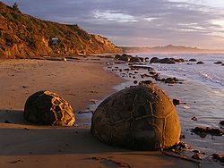 The Moeraki Boulders at sunrise.
The Moeraki Boulders are unusually large and spherical boulders lying along a stretch of Koekohe Beach on the wave cut Otago coast of New Zealand between Moeraki and Hampden, and are located at 45°20′42.99″S 170°49′33.82″E / 45.345275°S 170.8260611°E. They occur scattered either as isolated or clusters of boulders within a stretch of beach where they have been protected in a scientific reserve. The erosion by wave action of mudstone, comprising local bedrock and landslides, frequently exposes embedded isolated boulders. These boulders are grey-colored septarian concretions, which have been exhumed from the mudstone enclosing them and concentrated on the beach by coastal erosion.[1][2][3][4]
Local Māori legends explained the boulders as the remains of eel baskets, calabashes, and kumara washed ashore from the wreck of an Arai-te-uru, a large sailing canoe. This legend tells of the rocky shoals that extend seaward from Shag Point as being the petrified hull of this wreck and a nearby rocky promontory as being the body of the canoe's captain. In 1848 W.B.D. Mantell sketched the beach and its boulders, more numerous than now. The picture is now in the Alexander Turnbull Library in Wellington.[5] The boulders were described in 1850 colonial reports and numerous popular articles since that time. In more recent times they have become a popular tourist attraction, often described and pictured in numerous web pages and tourist guides.[5][3][6]
Contents
Physical character
 A clump of highly spherical boulders
The most striking aspect of the boulders is their unusually large size and spherical shape, with a distinct bimodal size distribution. Approximately one-third of the boulders range in size from about 0.5 to 1.0 metres (1.6 to 3.3 ft) in diameter, the other two-thirds from 1.5 to 2.2 metres (5 to 7.3 ft), mostly spherical or almost spherical. A small proportion of them are not spherical; being slightly elongated parallel to the bedding of the mudstone that once enclosed them.[1][3][4]
Neither the spherical to subspherical shape or large size of the Moeraki Boulders is unique to them. Virtually identical spherical boulders, called "Koutu Boulders", are found on the beaches, in the cliffs, and beneath the surface inland of the shore of Hokianga Harbour, North Island, New Zealand, between Koutu and Kauwhare points. Like the Moeraki Boulders, the almost spherical Koutu Boulders are as large as 3 metres (10 ft) in diameter.
Similar boulder-size concretions, known as "Katiki Boulders", are found on the north-facing shore of Shag Point some 12 miles south of where the Moeraki Boulders are found. These concretions occur as both spherical cannonball concretions and flat, disk-shaped or oval concretions. Unlike the Moeraki boulders, some of these concretions contain the bones of mosasaurs and plesiosaurs.[3]
Large spherical concretions, similar in size and shape to the Moeraki Boulders have been found elsewhere in the world. For example, large spherical concretions as large as 3 metres (10 feet) in diameter are along the Cannonball River within Morton and Sioux Counties, North Dakota. Large spherical concretions as much as 4 to 6 metres (13.2 to 20 feet) in diameter occur within sandstone outcrops of the Frontier Formation in northeast Utah and central Wyoming. Similar somewhat weathered and eroded giant spheroidal concretions, as large as 6 metres (20 feet) in diameter, are at Rock City in Ottawa County, Kansas. Smaller spherical concretions are found on the shore of Lake Huron near Kettle Point, Ontario, where they are known as "kettles".
Composition
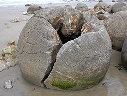 A boulder, showing the hollow interior
As determined by detailed analysis of the fine-grained rock using optical mineralogy, X-ray crystallography, and electron microprobe, the boulders consist of mud, fine silt and clay, cemented by calcite. The degree of cementation varies from being relatively weak within the interior of a boulder to quite hard within its outside rim. The outside rims of the larger boulders consist of much as 10 to 20% calcite, because the calcite not only tightly cements the silt and clay but has also replaced it to a significant degree.[1][4]
The rock comprising the bulk of a boulder is riddled with large cracks called "septaria" that radiate outward from a hollow core lined with scalenohedral calcite crystals. The process or processes that created septaria within Moeraki Boulders, and in other septarian concretions, remain an unresolved matter for which a number of possible explanations have been proposed. These cracks radiate and thin outward from the centre of the typical boulder and are typically filled with an outer (early stage) layer of brown calcite and an inner (late stage) layer of yellow calcite spar, which often, but not always, completely fills the cracks. Rare Moeraki Boulders have a very thin innermost (latest stage) layer of dolomite and quartz covering the yellow calcite spar.[1][3][4]
The composition of the Moeraki Boulders and the septaria that they contain are typical of, often virtually identical to, septarian concretions that have been found in exposures of sedimentary rocks in New Zealand and elsewhere. Pearson and Nelson (2005, 2006) describe in detail the occurrence of smaller but otherwise very similar septarian concretions within exposures of sedimentary rocks elsewhere in New Zealand. Similar septarian concretions have been found in the Kimmeridge Clay and Oxford Clay of England, and at many other locations worldwide.[7][8]
Origin
The Moeraki Boulders are concretions created by the cementation of the Paleocene mudstone of the Moeraki Formation, from which they have been exhumed by coastal erosion.
The main body of the boulders started forming in what was then marine mud, near the surface of the Paleocene sea floor. This is demonstrated by studies of their composition; specifically the magnesium and iron content, and stable isotopes of oxygen and carbon. Their spherical shape indicates that the source of calcium was mass diffusion, as opposed to fluid flow.
The larger boulders, 2 metres (6.6 feet) in diameter, are estimated to have taken 4 to 5.5 million years to grow while 10 to 50 metres (33 to 165 feet) of marine mud accumulated on the seafloor above them. After the concretions formed, large cracks known as septaria formed in them. Brown calcite, yellow calcite, and small amounts of dolomite and quartz progressively filled these cracks when a drop in sea level allowed fresh groundwater to flow through the mudstone enclosing them.[1][3][9][4]
References
- ^ a b c d e Boles, J.R., C.A. Landis, and P. Dale, 1985, The Moeraki Boulders; anatomy of some septarian concretions, Journal of Sedimentary Petrology, vol. 55, n. 3, p. 398-406.
- ^ Fordyce, E., and P. Maxwell, 2003, Canterbury Basin Paleontology and Stratigraphy, Geological Society of New Zealand Annual Field Conference 2003 Field Trip 8, Miscellaneous Publication 116B, Geological Society of New Zealand, Dunedin, New Zealand. ISBN 0-908678-97-5
- ^ a b c d e f Forsyth, P.J., and G. Coates, 1992, The Moeraki boulders. Institute of Geological & Nuclear Sciences, Information Series no. 1, (Lower Hutt, New Zealand)
- ^ a b c d e Thyne, G.D., and J.R. Boles, 1989, Isotopic evidence for origin of the Moeraki septarian concretions, New Zealand, Journal of Sedimentary Petrology. v. 59, n. 2, p. 272-279.
- ^ a b Dann, C. and N. Peat, 1989, Dunedin, North and South Otago. GP Books. Wellington, New Zealand. ISBN 0-477-01438-0.
- ^ Mutch, A. R., 1966, Moeraki Boulders in A.H. McLintock, ed., An Encyclopaedia of New Zealand. Government Printer, Wellington, New Zealand.
- ^ Scotchman, I.C., 1991, The geochemistry of concretions from the Kimmeridge Clay Formation of southern and eastern England, Sedimentology. v. 38, p. 79-106.
- ^ Hudson, J.D., M.L. Coleman, B.A. Barreiro and N.T.J. Hollingworth, 2001, Septarian concretions from the Oxford Clay (Jurassic, England, UK): involvement of original marine and multiple external pore fluids, Sedimentology. v. 48, p. 507-531.
- ^ Pearson, M.J., and C.S. Nelson, 2005, Organic geochemistry and stable isotope composition of New Zealand carbonate concretions and calcite fracture fills, New Zealand Journal of Geology & Geophysics. v. 48, p. 395-414.
Further reading
- Brunsden, D., 1969, Mystery of the Moeraki and Katiki boulders. Geographical Magazine. v. 41, n. 11, pp. 839-843.
- Klug, H., and R. Zakrzewski, R., 1986, Die Moeraki Boulders; Riesenkonkretionen am Strand auf Neuseelands Suedinsel (The Moeraki boulders; giant concretions of the beach of New Zealand's South Island) Schriften des Naturwissenschaftlichen Vereins fuer Schleswig-Holstein. v. 56, pp. 47-52
- Pearson, M.J., and C.S. Nelson, 2006, Organic chemical signatures of New Zealand carbonate concretions and calcite fracture fills as potential fluid migration indicators. in 2006 New Zealand Petroleum Conference Proceedings, Crown Minerals Group, Auckland, New Zealand.
See also
External links
- Moeraki Boulders
- Biek, B., 2002, Concretions and Nodules in North Dakota North Dakota Geological Survey, Bismark, North Dakota.
- Hokianga Tourism Association, nd, Koutu boulders Really nice pictures of cannonball concretions similar in size and origin to Moeraki Boulders.
- Irna, 2006, All that nature can never do, part IV : stone spheres
- Irna, 2007, Stone balls : in France too!
- Kitchens, O., nd, Moeraki Boulders a Photogallery of Pictures of Moeraki Boulders.
- Mozley, P.S., 1999, Concretions, Bombs, and Ground Water, Lite Geology, v. 14, p. 1-3 (Winter 1995)
- United States Geological Survey, nd, cannonball concretion
Coordinates: 45°20′42.99″S 170°49′33.82″E / 45.345275°S 170.8260611°E
Categories:- Otago Region
- Geology of New Zealand
- Coastline of New Zealand
- Rock formations in New Zealand


Wikimedia Foundation. 2010.