- Market Weighton
-
Coordinates: 53°51′51″N 0°39′45″W / 53.8642°N 0.6624°W
Market Weighton 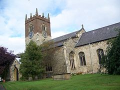
All Saints Church
Arms of Market Weighton Town Council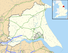
 Market Weighton
Market Weighton shown within the East Riding of YorkshirePopulation 5,212 (2001 census)[1] OS grid reference SE879417 Parish Market Weighton Unitary authority East Riding of Yorkshire Ceremonial county East Riding of Yorkshire Region Yorkshire and the Humber Country England Sovereign state United Kingdom Post town YORK Postcode district YO43 Dialling code 01430 Police Humberside Fire Humberside Ambulance Yorkshire EU Parliament Yorkshire and the Humber UK Parliament East Yorkshire List of places: UK • England • Yorkshire Market Weighton is a small town and civil parish in the East Riding of Yorkshire, England. It is one of the main market towns in the East Yorkshire Wolds and lies midway between Hull and York, about 20 miles (32 km) from either one. According to the 2001 UK census, Market Weighton parish had a population of 5,212.[1]
Historically it is listed in the Domesday Book as "Wicstun" and was granted its charter to become a market town in 1251. Architecturally the town boasts: a parish church, parts of which are Norman, the Londesborough Arms (an 18th century coaching inn), a Wesleyan chapel, a Methodist chapel and a high street still recognisable from the 1800s. Other sights of interest include the post office , the duck pond and Station Farm. Market Weighton has a bright and colourful history, largely based around William Bradley the Yorkshire Giant who at the age of 20 was an amazing seven feet and nine inches tall. Another resident was Peg Fyfe, the local witch, who reputedly skinned a young local resident alive in the 1660s and was later hanged for the crime but swallowed a spoon to save herself only to be "finished off" by two passing knights.[citation needed]
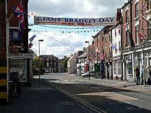
In May of each year local residents take to the streets of Market Weighton for the Giant Bradley Day festival in a celebration of the life and times of William Bradley.
Industry in the town is largely based around agriculture. The town is known geologically for having given its name to the Market Weighton Axis.
The Yorkshire Wolds Way National Trail, a long distance footpath, passes through the town.
Contents
Governance
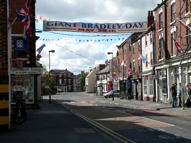
 High Street
Market Weighton has a town council, who operate under the East Riding of Yorkshire County Council.
Noted people from Market Weighton
- William Bradley (1787–1820), tallest ever Briton
- Frank Mitchell (1872–1935), cricketer[2]
Transport
The town used to be a good route centre for connecting major cities York and Hull and used to have a railway station at the junction of the lines from Selby to Driffield and York to Beverley, but the last train ran in 1965. The abandoned lines north of the town are used as scenic walks and cycle routes, comprising nature reserves etc. Bus service X46, provided by East Yorkshire Motor Services, runs hourly and links the town with Beverley, Hull, Pocklington and York.
The three-mile £5.1 million A1079 bypass opened in March 1991.
The Minsters Rail Campaign is campaigning to re-open the railway line between Beverley and York (with stops at Stamford Bridge, Pocklington and Market Weighton). The re-opened railway would skirt the edge of the town as the former alignment has since been developed. [3]
See also
References
- ^ a b "2001 Census: Key Statistics: Parish Headcounts: Area: Market Weighton CP (Parish)". Neighbourhood Statistics. Office for National Statistics. http://neighbourhood.statistics.gov.uk/dissemination/LeadTableView.do?a=3&b=791000&c=Market+Weighton&d=16&e=15&g=391464&i=1001x1003x1004&m=0&r=1&s=1211193324251&enc=1&dsFamilyId=779. Retrieved 19 May 2008.
- ^ Frank Mitchell's obituary in the 1936 Wisden Cricketers' Almanack
- ^ http://www.minstersrail.org.uk/
- Gazetteer — A–Z of Towns Villages and Hamlets. East Riding of Yorkshire Council. 2006. p. 8.
External links
- Market Weighton Homepage
- Market Weighton Community Website
- The Market Weighton Reference Website
- Information about William Bradley and Giant Bradley Day
- Market Weighton United AFC
Ceremonial county of East Riding of Yorkshire Yorkshire Portal Unitary authorities Major settlements Beverley • Bridlington • Brough • Driffield • Goole • Hedon • Hessle • Hornsea • Howden • Kingston upon Hull • Market Weighton • Pocklington • Snaith • South Cave • Withernsea
See also: List of civil parishes in East Riding of YorkshireRivers Canals Topics History • Parliamentary constituencies • Grade I listed buildings • Monastic houses • Museums • SSSIs • WindmillsCategories:- Market towns in the East Riding of Yorkshire
- Civil parishes in the East Riding of Yorkshire
- Towns in the East Riding of Yorkshire


Wikimedia Foundation. 2010.