- Old Crow, Yukon
-
Old Crow
TeechikCoordinates: 67°34′N 139°48′W / 67.567°N 139.8°WCoordinates: 67°34′N 139°48′W / 67.567°N 139.8°W Country  Canada
Territory  Yukon
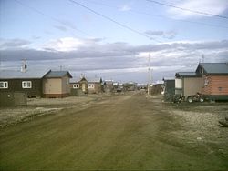
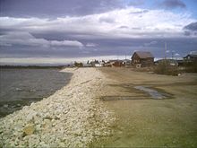
YukonPopulation (2008) - Total 267 Time zone Pacific (PST) (UTC-8) - Summer (DST) PDT (UTC-7) Old Crow (Teechik[1] in Gwich’in) is a dry community in the Canadian Territory of Yukon and is a periglacial environment. It had 267 inhabitants as of 2008, most of them belonging to the Gwichʼin-speaking Aboriginal Vuntut Gwitchin First Nation. The community is situated on the Porcupine River in the far north of the territory. Old Crow is the only Yukon community that cannot be reached by car so one must fly in to the Old Crow Airport in order to reach it.
The people of Old Crow are dependent on the Porcupine caribou herd for food and clothing.[2] The Porcupine caribou herd migrates to the coastal plain in the Arctic National Wildlife Refuge (ANWR) in Alaska to give birth to their young. Many citizens of Old Crow believe the herd is being seriously threatened by oil-drilling in the ANWR and have been heavily involved in lobbying to prevent it.
A large number of apparently human modified animal bones have been discovered in the Old Crow area, notably at Bluefish Caves, located near the shores of the Arctic Ocean, that have been dated to 25,000-40,000 years ago by carbon dating, several thousand years earlier than generally accepted human habitation of North America.[3]
Contents
Climate
Old Crow has a cold subarctic climate. Average annual temperature is −9 °C (15.80 °F). Old Crow experiences annual temperature average daily highs of 20.6 °C (69.08 °F) in July and average daily lows of −35.7 °C (−32.26 °F) in January. Record high temperature was 32.8 °C (91.04 °F) on August 30, 1976 and the lowest was −59.4 °C (−74.92 °F) on January 5, 1975. Old Crow has little precipitation with an average annual snowfall of 129.3 centimetres (50.91 in) and 144.2 millimetres (5.68 in) of rainfall.
Climate data for Old Crow Airport Month Jan Feb Mar Apr May Jun Jul Aug Sep Oct Nov Dec Year Record high °C (°F) 2.5
(36.5)3.0
(37.4)6.7
(44.1)13.5
(56.3)26.0
(78.8)32.0
(89.6)31.0
(87.8)32.8
(91.0)23.9
(75.0)17.5
(63.5)6.1
(43.0)9.0
(48.2)32.8
(91.0)Average high °C (°F) −26.7
(−16.1)−22.5
(−8.5)−15.2
(4.6)−4.6
(23.7)8.3
(46.9)18.5
(65.3)20.6
(69.1)16.6
(61.9)7.8
(46.0)−6.1
(21.0)−19.1
(−2.4)−22.4
(−8.3)−3.7 Daily mean °C (°F) −31.1
(−24.0)−27.6
(−17.7)−21.7
(−7.1)−11.1
(12.0)2.5
(36.5)12.4
(54.3)14.6
(58.3)10.9
(51.6)3.2
(37.8)−9.7
(14.5)−23.2
(−9.8)−27
(−17)−9 Average low °C (°F) −35.7
(−32.3)−32.5
(−26.5)−28.1
(−18.6)−17.6
(0.3)−3.3
(26.1)6.2
(43.2)8.6
(47.5)5.3
(41.5)−1.5
(29.3)−13.2
(8.2)−27.5
(−17.5)−31.7
(−25.1)−14.2 Record low °C (°F) −59.4
(−74.9)−54.4
(−65.9)−48.3
(−54.9)−39.5
(−39.1)−28
(−18.4)−8.3
(17.1)−2.5
(27.5)−9.5
(14.9)−22.5
(−8.5)−38
(−36.4)−47
(−52.6)−56.7
(−70.1)−59.4
(−74.9)Precipitation mm (inches) 11.9
(0.469)11.8
(0.465)11.9
(0.469)8.2
(0.323)14.7
(0.579)36.4
(1.433)36.0
(1.417)46.4
(1.827)32.0
(1.26)24.4
(0.961)17.8
(0.701)14.0
(0.551)265.5
(10.453)Source: 1971-2000 Environment Canada[4] Population data
Canada census – Old Crow, Yukon Community Profile 2006 Population:
Land area:
Population density:
Median age:
Total private dwellings:
Mean household income:253 (-15.4% from 2001)
14.15 km2 (5.46 sq mi)
17.9 /km2 (46 /sq mi)
N/A (males: 39.0, females: 39.5)
153
$28,244
References: 2006[5] References
- ^ ANLC : Alaska Native Place Names
- ^ Fralic, Shelley (5 November 2009). "Olympic celebration and survival in Old Crow". National Post. http://www.nationalpost.com/news/story.html?id=2187310. Retrieved 4 February 2011.
- ^ Morlan, R.E. (1986), Pleistocene archaeology in Old Crow Basin: a critical reappraisal. In Bryan, A.L.,ed. New Evidence for the Pleistocene Peopling of the Americas. Orono,Maine,Center for the study of Early Man,pp.27-48.
- ^ Environment Canada—Canadian Climate Normals 1971–2000. Retrieved 14 June 2011.
- ^ "2006 Community Profiles". Statistics Canada. Government of Canada. 2009-02-24. http://www12.statcan.ca/census-recensement/2006/dp-pd/prof/92-591/index.cfm?Lang=E. Retrieved 2009-02-24.
Further reading
- Josie, Edith. Old Crow News: The Best of Edith Josie, 1964. Whitehorse, Yukon: Whitehorse Star, 1964.
- McSkimming, Robert James. Territory, Territoriality and Cultural Change in an Indigenous Society: Old Crow, Yukon Territory. [S.l: s.n.], 1975.
External links
- Old Crow's official website
- Vuntut Gwitchin Government website
- Old Crow: Land of the Vuntut Gwitch'in
- Community profile
- Webpage about the Old Crow Airport on the Canadian Owners & Pilots Association Places to Fly Airport Directory
- Watch The Challenge in Old Crow, a National Film Board of Canada documentary
 Subdivisions of Yukon
Regions Communities Beaver Creek · Burwash Landing · Carcross · Carmacks · Champagne Landing · Destruction Bay · Dawson City · Faro · Haines Junction · Ibex Valley · Keno City · Marsh Lake · Mayo · Mount Lorne · Old Crow · Pelly Crossing · Ross River · Tagish · Teslin · Upper Liard · Watson Lake · WhitehorseGhost towns Parks  Category:Yukon ·
  Portal:Yukon ·
  WikiProject:Canadian TerritoriesCategories:
- Settlements in Yukon
- Gwich’in
- Populated places in Arctic Canada
Wikimedia Foundation. 2010.


