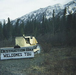
- Destruction Bay, Yukon
-
Destruction Bay Welcome sign made on an old bulldozer Coordinates: 61°15′15″N 138°48′24″W / 61.25417°N 138.80667°WCoordinates: 61°15′15″N 138°48′24″W / 61.25417°N 138.80667°W Country  Canada
Territory  Yukon
YukonPopulation (2001) – Total 43 Time zone Pacific (PST) (UTC-8) – Summer (DST) PDT (UTC-7) Destruction Bay is a small community on the Alaska Highway (historical mile 1083) in Canada's Yukon on Kluane Lake. Population in 2001 according to the Census was 43. The Yukon Government's Bureau of Statistics estimated the population at 59 in June 2005.
Populated mostly by non-aboriginal residents, community residents provide Yukon government services to residents in the area (school, highway maintenance), including nearby Burwash Landing and some tourism-related businesses along the Alaska Highway. The name is derived from the wind blowing down structures erected by the military during highway construction in 1942-43.
The community has a one room school serving kindergarten through Grade Eight.
External links
 Subdivisions of Yukon
Regions Communities Beaver Creek · Burwash Landing · Carcross · Carmacks · Champagne Landing · Destruction Bay · Dawson City · Faro · Haines Junction · Ibex Valley · Keno City · Marsh Lake · Mayo · Mount Lorne · Old Crow · Pelly Crossing · Ross River · Tagish · Teslin · Upper Liard · Watson Lake · WhitehorseGhost towns Parks Categories:- Settlements in Yukon
- Yukon geography stubs
Wikimedia Foundation. 2010.


