- Marlboro Township, Stark County, Ohio
-
Marlboro Township, Stark County, Ohio — Township — Municipalities and townships of Stark County.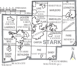
Coordinates: 40°56′44″N 81°14′30″W / 40.94556°N 81.24167°WCoordinates: 40°56′44″N 81°14′30″W / 40.94556°N 81.24167°W Country United States State Ohio County Stark Area – Total 36.5 sq mi (94.4 km2) – Land 35.8 sq mi (92.8 km2) – Water 0.6 sq mi (1.6 km2) Elevation[1] 1,217 ft (371 m) Population (2000) – Total 4,227 – Density 118.0/sq mi (45.5/km2) Time zone Eastern (EST) (UTC-5) – Summer (DST) EDT (UTC-4) FIPS code 39-47936[2] GNIS feature ID 1086981[1] Marlboro Township is one of the seventeen townships of Stark County, Ohio, United States. The 2000 census found 4,227 people in the township.[3]
Contents
Geography
Located in the northern part of the county, it borders the following townships:
- Randolph Township, Portage County - north
- Atwater Township, Portage County - northeast
- Lexington Township - east
- Washington Township - southeast
- Nimishillen Township - south
- Plain Township - southwest corner
- Lake Township - west
No municipalities are located in Marlboro Township, although locations within the township are often given a Hartville, Louisville, or Alliance address.
Name and history
Statewide, the only other Marlboro Township is located in Delaware County.
Government
Historical populations Census Pop. %± 1830 1,027 — 1840 1,670 62.6% 1850 2,133 27.7% 1860 2,270 6.4% 1870 1,870 −17.6% 1880 1,942 3.9% 1890 1,808 −6.9% 1900 1,829 1.2% 1910 1,606 −12.2% 1920 1,663 3.5% 1930 2,113 27.1% 1940 2,244 6.2% 1950 2,489 10.9% 1960 3,078 23.7% 1970 3,552 15.4% 1990 3,687 — 2000 4,227 14.6% [4] The township is governed by a three-member board of trustees, who are elected in November of odd-numbered years to a four-year term beginning on the following January 1. Two are elected in the year after the presidential election and one is elected in the year before it. There is also an elected township fiscal officer,[5] who serves a four-year term beginning on April 1 of the year after the election, which is held in November of the year before the presidential election. Vacancies in the fiscal officership or on the board of trustees are filled by the remaining trustees.
References
- ^ a b "US Board on Geographic Names". United States Geological Survey. 2007-10-25. http://geonames.usgs.gov. Retrieved 2008-01-31.
- ^ "American FactFinder". United States Census Bureau. http://factfinder.census.gov. Retrieved 2008-01-31.
- ^ Stark County, Ohio — Population by Places Estimates Ohio State University, 2007. Accessed 15 May 2007.
- ^ census data: 1830 : Kilbourn, John (1831). The Ohio gazetteer: or, Topographical dictionary: describing the several ... in the State of Ohio. self. p. 332. http://books.google.com/books?id=CDUWAAAAYAAJ&pg=PA332&dq=Stark. , 1840, 1880 : Howe, Henry (1907). Historical Collections of Ohio, The Ohio Centennial Edition. The State of Ohio. p. 285. http://books.google.com/books?id=cBDVAAAAMAAJ&pg=PA285. , 1850, 1860, 1870 : 1870 page 35 , 1890, 1900 : Hunt, William C. (1901). Population of the United States by states and territories, counties, and minor Civil Divisions, as returned at the Twelfth Census: 1900. United States Census Printing Office. p. 318. http://books.google.com/books?id=Pnk9AAAAYAAJ&pg=PA318. , 1910, 1920, 1930 : 1930 page 56 , 1940, 1950 : 1950 page 21 , 1960, 1970 : 1970 page 135 , 1990 : 1990 , 2000 : 2000
- ^ §503.24, §505.01, and §507.01 of the Ohio Revised Code. Accessed 4/30/2009.
External links
Municipalities and communities of Stark County, Ohio Cities Alliance‡ | Canal Fulton | Canton | Louisville | Massillon | North Canton

Villages Beach City | Brewster | East Canton | East Sparta | Hartville | Hills and Dales | Limaville | Magnolia‡ | Meyers Lake | Minerva‡ | Navarre | Waynesburg | Wilmot
Townships Bethlehem | Canton | Jackson | Lake | Lawrence | Lexington | Marlboro | Nimishillen | Osnaburg | Paris | Perry | Pike | Plain | Sandy | Sugar Creek | Tuscarawas | Washington
CDPs Unincorporated
communitiesAvondale | Cairo | Marchand | Maximo | Middlebranch | New Franklin | North Industry | North Lawrence | Paris | Richville | Robertsville | Waco
Footnotes ‡This populated place also has portions in an adjacent county or counties
Categories:- Townships in Stark County, Ohio


Wikimedia Foundation. 2010.