- Uniontown, Ohio
Infobox Settlement
official_name = Uniontown, Ohio
settlement_type = CDP
nickname =
motto =
imagesize =
image_caption =
image_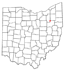
mapsize = 250px
map_caption = Location of Uniontown, Ohio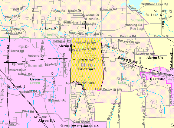
mapsize1 = 250px
map_caption1 = Detailed map of Uniontownsubdivision_type = Country
subdivision_name =United States
subdivision_type1 = State
subdivision_name1 =Ohio
subdivision_type2 = County
subdivision_name2 = Starkgovernment_footnotes =
government_type =
leader_title =
leader_name =
leader_title1 =
leader_name1 =
established_title =
established_date =unit_pref = Imperial
area_footnotes =area_magnitude =
area_total_km2 = 6.5
area_land_km2 = 6.5
area_water_km2 = 0.1
area_total_sq_mi = 2.5
area_land_sq_mi = 2.5
area_water_sq_mi = 0.0population_as_of = 2000
population_footnotes =
population_total = 2802
population_density_km2 = 433.4
population_density_sq_mi = 1122.5timezone = Eastern (EST)
utc_offset = -5
timezone_DST = EDT
utc_offset_DST = -4
elevation_footnotes = GR|3
elevation_m = 341
elevation_ft = 1119
latd = 40 |latm = 58 |lats = 35 |latNS = N
longd = 81 |longm = 24 |longs = 26 |longEW = Wpostal_code_type =
ZIP code
postal_code = 44685
area_code = 330
blank_name = FIPS code
blank_info = 39-78736GR|2
blank1_name = GNIS feature ID
blank1_info = 1065407GR|3
website =
footnotes =Uniontown is a
census-designated place (CDP) in Stark County,Ohio ,United States . The population was 2,802 at the 2000 census. It is often confused to being part ofSummit County, Ohio , primarily because the Uniontown post office serves a large part of the city of Green in Summit County. Uniontown was named #69 on CNN Money's [http://money.cnn.com/magazines/moneymag/bplive/2005/index.html "Best Places to Live 2005"] list. Uniontown is part of the Canton–Massillon Metropolitan Statistical Area.Geography
Uniontown is located at coor dms|40|58|35|N|81|24|26|W|,GR|1 along the
Tuscarawas River . [DeLorme (1991). "Ohio Atlas & Gazetteer". Yarmouth, Maine: DeLorme. ISBN 0-89933-233-1.]According to the
United States Census Bureau , the CDP has a total area of 2.5square mile s (6.5km² ), of which, 2.5 square miles (6.5 km²) of it is land and 0.04 square miles (0.1 km²) of it (0.79%) is water.It is the location of the IEL Superfund site.
Demographics
As of the
census GR|2 of 2000, there were 2,802 people, 1,141 households, and 861 families residing in the CDP. Thepopulation density was 1,122.5 people per square mile (432.7/km²). There were 1,171 housing units at an average density of 469.1/sq mi (180.9/km²). The racial makeup of the CDP was 98.14% White, 0.32% African American, 0.14% Native American, 0.54% Asian, 0.14% from other races, and 0.71% from two or more races. Hispanic or Latino of any race were 0.50% of the population.There were 1,141 households out of which 26.2% had children under the age of 18 living with them, 65.7% were married couples living together, 7.4% had a female householder with no husband present, and 24.5% were non-families. 21.5% of all households were made up of individuals and 10.2% had someone living alone who was 65 years of age or older. The average household size was 2.46 and the average family size was 2.86.
In the CDP the population was spread out with 20.9% under the age of 18, 5.9% from 18 to 24, 24.6% from 25 to 44, 30.3% from 45 to 64, and 18.3% who were 65 years of age or older. The median age was 44 years. For every 100 females there were 90.4 males. For every 100 females age 18 and over, there were 88.5 males.
The median income for a household in the CDP was $47,206, and the median income for a family was $60,510. Males had a median income of $45,212 versus $28,625 for females. The
per capita income for the CDP was $23,108. About 0.8% of families and 2.7% of the population were below thepoverty line , including none of those under age 18 and 4.2% of those age 65 or over.References
External links
Wikimedia Foundation. 2010.