- Kŭmgangsan
-
Kŭmgangsan 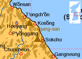
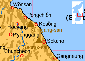
Location of Kŭmgangsan.Elevation 1,638 m (5,374 ft) Location Location Kŭmgangsan Tourist Region, North Korea Korean name Hangul 금강산 Hanja 金剛山 Revised Romanization Geumgangsan McCune–Reischauer Kŭmgangsan  The path to Koryoung Falls
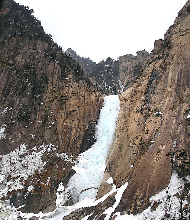
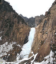 Kuryong Falls
Kŭmgangsan (Korean pronunciation: [kɯmɡaŋsan]), Geumgangsan, or Mount Geumgang is a 1,638 metres (5,374 ft)-high mountain in Kangwon-do, North Korea. Its name means "a firm heart in the face of truth".[citation needed] It is about 50 km away from South Korea's Sokcho in Gangwon-do. It is one of the best-known mountains in North Korea.[1] It is located on the east coast of the country, in Kŭmgangsan Tourist Region, formerly part of Kangwŏn Province (38.58N, 128.17E). Kŭmgangsan is part of the Taebaek mountain range which runs along the east of the Korean peninsula. The name means Vajra (or Diamond) Mountain.
Contents
Seasonal names
Kŭmgangsan has been known for its scenic beauty since antiquity[2][3][4] and is the subject of many different works of art. Including its spring name, Kŭmgang (Hangeul: 금강산, Hanja: 金剛), it has many different names for each season, but it is most widely known today as Kŭmgangsan. In summer it is called Pongraesan (봉래산, 蓬萊山: the place where a Spirit dwells); in autumn, Phung'aksan (풍악산, 楓岳山: hill of colored leaves, or 楓骨山: great mountain of colored leaves[5]); in winter, Kaegolsan (개골산, 皆骨山: stone bone mountain).
Geography
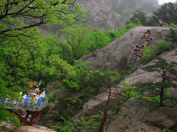
The mountain consists almost entirely of granite and diorite, weathered over centuries into a wide variety of shapes, including over 12,000 picturesque stone formations, ravines, cliffs, stone pillars, and peaks.
Kŭmgangsan is commonly divided into three areas: Inner Kŭmgang, Outer Kŭmgang, and Sea Kŭmgang, each with different geological and topographical features.
- Inner Kŭmgang is noted for its views. The Manpok ravine is popular with tourists.
- Outer Kŭmgang is noted for the large number of peaks. Chipson Peak (rock of ten thousand forms) is known for its many waterfalls.
- The Sea Kŭmgang area is known for the lagoons and stone pillars.
Kŭmgangsan Tourist Region
Since 1998, South Korean tourists have been allowed to visit Kŭmgangsan, initially travelling by cruise ship, but recently more commonly by coach. In 2002, the area around the mountain was separated from Kangwŏn Province and organized as a separately-administered Tourist Region. The land route was opened in 2003. A rail link exists on the North Korean side up to the border, but no tracks are laid between Gangneung and the border in South Korea.
In 1998, there were 15,500 tourists in November and December, in 1999 there were 148,000, and in 2000 213,000. In 2001 tourist numbers dropped to 58,000 amidst disagreements over the access over land. As of 2002[update], almost 500,000 have visited the Kŭmgangsan Tourist Region. Tourist numbers have since established themselves at about 240,000 a year. In June 2005, Hyundai Asan announced the 1 millionth South Korean visit to the area.[6]
The Kŭmgangsan Tourist Region is thought to be one way for the North Korean government to receive hard currency from abroad. Therefore the official currency of the tour is neither the South Korean won nor the North Korean won, but the US dollar.[citation needed] Since 2003, food and services to South Korean tourists are provided by some North Koreans. But most of the staff in the hotels are Chinese citizens of Korean heritage with Korean language skills. The area is developed by Hyundai Asan, which plans to expand the site with a proper ski resort to complement the current sleigh course, and complete golf courses. Many plans for expansion, however, are in their earliest stages.[citation needed]
On the morning of July 11, 2008, a 53-year-old South-Korean tourist was shot and killed while walking on the resort's beach. Wang-ja entered a military area by crossing over a sand dune and was shot twice by North Korean soldiers. North Korea claimed that sentries had no choice but to shoot her because, despite their order to stop, she fled. South Korea demanded an on-the-spot survey, but North Korea declined it, claiming all the facts were clear and all responsibilities were the victim's and South Korea's. Due to the shooting, South Korea temporarily suspended all trips to Kŭmgangsan.[7] In March 2010, the DPRK government warned of "extraordinary measures" if the tourism ban were not lifted.[8] On April 23, 2010, the North Korean government seized 5 properties owned by South Korea at the resort, saying that it was done "in compensation for the damage the North side suffered due to the suspension of the tour for a long period". In seizing the properties, North Korea also alluded to the Baengnyeong incident, showing displeasure with South Korea blaming North Korea for the sinking of the ship.[9] Since April 2010, North Korea is now permitting companies to run tours from the North Korean side,[10] making it appear increasingly unlikely that tours will be resumed from the South. However, on October 1, 2010, news reports said, "Red Cross officials from the two Koreas agreed Friday to hold reunions for families separated by the Korean War amid mixed signals from North Korea on easing tensions over the sinking of a South Korean warship. One hundred families from each country will attend the meetings from Oct. 30 to Nov. 5 at a hotel and reunion center at the North's scenic Diamond Mountain resort, Unification Ministry spokeswoman Lee Jong-joo said." .[11]. As of September 2011 North Korea have begun operating cruises directly from Rason in north-eastern North Korea, to the port in Kumgangsan, offering visitors the chance to stay in the resorts previously run by the south. Although they are aimed primarily at Chinese guests, western companies are also offering the tours .[12]
See also
Notes and references
- ^ The Associated Press (September 22, 2000). "North Korea approves Japanese tours to Mount Kumgang". CNN. http://archives.cnn.com/2000/TRAVEL/NEWS/09/22/japan.koreastourism.ap/index.html.
- ^ "North Korea Relief". Encyclopedia Britannica. http://original.britannica.com/eb/article-34920/North-Korea#411419.hook. "Mount Kŭmgang (5,374 feet), is renowned for its scenic beauty."
- ^ Susan Chira (February 2, 1989). "The two Koreans agree to develop resort in North". New York Times. http://query.nytimes.com/gst/fullpage.html?res=950DE4DC1638F931A35751C0A96F948260&sec=&spon=&pagewanted=all.
- ^ Aidan Foster-Carter (March 30, 2001). "PYONGYANG WATCH Hyundai and North Korea: What now?". Asia Times Online. http://www.atimes.com/koreas/CC30Dg02.html. "Kumgangsan - the famously scenic Diamond Mountains just above the DMZ"
- ^ Yi I's book, 풍악행, refers to the mountain by this name.
- ^ Hankooki.com
- ^ Chosun Ilbo
- ^ "North Korea issues warning over Mount Kumgang tour ban". BBC News. 25 March 2010. http://news.bbc.co.uk/2/hi/asia-pacific/8586440.stm.
- ^ "North Korea 'to seize property at Kumgang resort'". BBC News. April 23, 2010. http://news.bbc.co.uk/2/hi/asia-pacific/8639065.stm.
- ^ "North Korea 'two new resorts open to public'". Young Pioneer Tours. http://www.youngpioneertours.com/.
- ^ [1]
- ^ [2]
External links
Coordinates: 38°31′34″N 128°03′06″E / 38.52611°N 128.05167°E
Categories:- Mountains of North Korea
- Tourism in North Korea
Wikimedia Foundation. 2010.