- San Diego–Tijuana metropolitan area
Infobox American International Metropolitan Area
metropolitan_name = San Diego–Tijuana metropolitan area
name = San Diego-Tijuana
largest_city = flagicon|USA San Diego, CA
flagicon|MEX Tijuana, BC
other_cities = San Diego
-Chula Vista
-Oceanside
-Escondido
-El Cajon
-Carlsbad
-Vista
-San Marcos
Tijuana
-Playas de Rosarito
-Tecate
rank_america = 21
population = 5,043,350 (2008 calc.) [http://world-gazetteer.com/wg.php?x=&men=gpro&lng=en&dat=32&geo=-223&srt=pnan&col=aohdq&pt=a&va=&geo=-1049427 World Gazetteer – San Diego-Tijuana] ]
density_mi2 = 1020
density_km2 = 394
area_mi2 = 4,825
area_km2 = 12,496
subdivisions = flagicon|USA California
-San Diego County
flagicon|MEX Baja California
-Municipality of Tijuana
-Municipality of Rosarito
time_zones = UTC-8
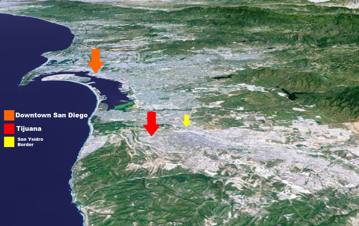
The San Diego–Tijuana Metropolitan Area is the name of anurban agglomeration surrounding the cities ofSan Diego ,California ,United States andTijuana ,Baja California ,Mexico . The region consists of San Diego County in the United States and the municipalities of Tijuana, Playas de Rosarito, and Tecate in Mexico. The total population of the region has been estimated to be just over 5 million in 2008, making it the 21st largest metropolitan area in the Americas [http://world-gazetteer.com/wg.php?x=&men=gcis&lng=en&dat=32&geo=-2&srt=pnan&col=aohdq&va=&pt=a World Gazetteer – Metropolitan Areas of America] ] and the largest bi-national metropolitan area that is shared between US and Mexico. The two cities together placed a bid to be the host of the2016 Summer Olympics , and if the bid had not been withdrawn, the joint-cities could have been the first bi-national host of the Olympics. [ [http://www.sandiegometro.com/2003/dec/coverstory2.html SanDiegometro.com The World's First Binational Olympics Proposed For Tijuana And San Diego.] ]Geography
Both San Diego and Tijuana are situated along the Pacific Coast and on the border between United States and Mexico. The metropolitan area lies just south of Orange County, West of
Imperial County , and shares borders withGreater Los Angeles . To the East of Tijuana, lies the large city ofMexicali who shares another cross-border metropolitan area with Imperial Valley Communities. To the South of Tijuana lies the cities ofPlayas de Rosarito andEnsenada . Ensenada is sometimes considered part of the Metropolitan area. The urbanized area where San Diego and Tijuana meet is called San Ysidro on the American side of the border and Colonia Federal/Colonia Libertad on the Mexican side. Further east, the Mexican delegaciones of Mesa de Otay and Centenario are heavy urbanized whereas the corresponding American area of Otay Mesa primarily has dispersed industrial and distribution facilities with scattered strip malls. The area where the Pacific Ocean meets the border is only urbanized on the Mexican side of the border as the American side of the border is a park containing the estuary of the Tijuana River.an Diego County
San Diego County, has a varied topography. On its western side is seventy miles of coastline. Snow-capped mountains rise to the northeast, with the
Sonoran Desert to the far east. TheCleveland National Forest is in the northeast portion of the county. According to the U.S. Census Bureau, the county has a total area of 11,721 km² (4,526 mi²). 10,878 km² (4,200 mi²) of it is land and 843 km² (326 mi²) of it (7.20%) is water.San Diego is located at coord|32|42|N|117|09|W|, just north of
Tijuana . San Diego has deep canyons separating its mesas, creating small pockets of natural parkland scattered throughout the city.Downtown San Diego is located on theSan Diego Bay , It is surrounded by several dense urban communities and abruptly ends in Hillcrest to the north. The Coronado andPoint Loma peninsulas separate San Diego Bay from the ocean.Ocean Beach is on the west side of Point Loma. Mission Beach and Pacific Beach lie between the ocean and Mission Bay, a man-made aquatic park.La Jolla lies north of Pacific Beach. Mountains rise to the east of the city, and beyond the mountains are desert areas. Numerous farms are found in the valleys northeast and southeast of the city. San Diego County has more endangered plant and animal species (as determined byUnited States Environmental Protection Agency ) than any other county in the United States.Urban communities of San Diego County
San Diego County features many urban communities that are mainly situated on the south side of Interstate 8.
Tijuana
Tijuana is located at coord|32|31|N|117|01|W|, just south of San Diego. The city streches eastward from the intersection of the Mexico/U.S. border with the Pacific Ocean and follows the course of the Tijuana River Valley. The terrain is extremely varied, including flood plains, canyons, steep hills, and mesas. The adjacent city and formerly part of Tijuana is
Playas de Rosarito , which became independent in 1995. The city is divided into nine administrative boroughs ("delegaciones", in Spanish), which are in turn divided into colonias. These boroughs offer administrative services such asurban planning ,civil registry , inspection, verification,public work s and community development and are served by a "delegado". Because Tijuana is more important in the Mexican urban hierarchy than San Diego is in the American urban hierarchy (and does not suffer from competition from a larger urban center as San Diego does from Los Angeles), Tijuana contains many foreign embassies and consulates including those of China, Korea, Finland, the United States, Germany, Spain, Honduras, France, Austria, Gambia, the United Kingdom, Italy, Norway, Sweden, Israel, Canada, and the Czech Republic. Population density is much higher in the immediate border area in Mexico that it is in the United States. Urban growth is currently to the east and south of Tijuana where developers are building many new residential communities.Major cities
Broadcasting
Broadcasting is necessarily shared between the two cities, and as along both of the U.S.'s borders,frequency coordination means that allbroadcast station s must be approved by both countries before making any major changes. In this case, it is theFCC in the U.S., andCoFeTel (under theSecretaría de Comunicaciones y Transportes , meaning "Secretary of Communications and Transport") in Mexico. Additonally, the FCC requires a permit to supply programming to a foreign broadcaster for transmission back into the U.S.This is quite common in the area, for example the local
The CW affiliate isXETV 6, the X (instead of a K) indicating it is a Mexican-licensed station. The two other such TV stations areMy Network TV onXHDTV 49, andMiami -based (andNBC -owned)Telemundo onXHAS 33. These stations will not be required to shut-down theirNTSC analog TV operations inFebruary 2009 , as FCC-licensed stations must. Because of this, a bill pending (as of August 2008 ) in theU.S. Congress called theDTV Border Fix Act may allow stations in San Diego to keep their analog transmissions on the air for another five years. This would apply along the entire Mexican border and within 80 kilometers (50 miles) of it, but not the Canadian border zone, where such cross-border relays are not used. Onradio , relaying programming across the border is even more common, with stations likeXHITZ FM 90.3 andXHMORE FM 98.9 being programmed by U.S.broadcast group s, while being owned by Mexican companies (as required under Mexican law) and operating under Mexicanbroadcast law . Other American stations relayed via Mexico throughlocal marketing agreement s (LMAs) areXEPE AM 1700,XEPRS AM 1090 andsimulcast XHPRS FM 105.7,XESPN AM 800,XESURF AM 540,XETRA FM 91.1,XHRM FM 92.5,XEWW AM 690,XHA FM 94.5,XHFG FM 107.3,XHGLX FM 91.7,XHLNC FM 90.7, andXHTY FM 99.7. All of these stations are authorized by CoFeTel to simulcast digitally inHD Radio , as are other stations within 320 kilometers (200 miles) of the U.S. border. [http://www.radioink.com/HeadlineEntry.asp?hid=142268&pt=todaysnews]Because many stations in the
reserved band (FM below 92MHz) are used by Mexican stations, other specific allotments are reserved fornon-commercial educational (NCE) stations in the San Diego area. However, the lack of such allotments still leaves the area with nocollege radio stations available except viaInternet streaming audio ,cable radio ,LPAM , and TV SAP. These are KCR fromSDSU , and KSDT fromUCSD .Economy
an Diego
Several areas of San Diego are home to offices and research facilities for numerous biotechnology companies and pharmaceutical companies. The presence of
University of California, San Diego and other research institutions helped fuel biotechnology growth. In June 2004, San Diego was ranked the top biotech cluster in the U.S. by the Milken Institute. [cite web | title=MilkenInstitute.org | url=http://www.milkeninstitute.org/publications/publications.taf?function=detail&ID=312&cat=ResRep | work=America's Biotech and Life Science Clusters: San Diego's Position and Economic Contributions | accessdate=2006-12-10]San Diego is home to companies that develop wireless cellular technology.
Qualcomm Incorporated was founded and is headquartered in San Diego; Qualcomm is the largest private-sector technology employer (excluding hospitals) in San Diego County. [cite web | title=SD Daily Transcript | url=http://www.sddt.com/Databases/BusinessListings/ListCompanies.cfm?BusinessCategory_ID=140 | work=Largest employers in San Diego County | accessdate=2006-05-20]The economy of San Diego is influenced by its port, which includes the only major submarine and shipbuilding yards on the West Coast, as well as the largest naval fleet in the world. The cruise ship industry, which is the second largest in California, generates an estimated $2 million annually from the purchase of food, fuel, supplies, and maintenance services. [cite news|url=http://proquest.umi.com/pqdweb?did=711835761&sid=4&Fmt=3&clientId=16256&RQT=309&VName=PQD|title=Cruise Ships Face Stiffer Anti-Pollution Policies|author=Connie Lewis|publisher=
Proquest : [http://www.sdbj.com/ San Diego Business Journal] |quote=The Port of San Diego is the state's fastest-growing port in terms of cruise ship dockings, and the second largest behind the Port of Los Angeles... ...The dockings are estimated to have an economic impact of more than $2 million on the local economy from the purchase of food, supplies and fuel,, as well as maintenance services.]Due to San Diego's military influence, major national defense contractors, such as
General Atomics andScience Applications International Corporation , are headquartered in San Diego.Tourism is also a major industry, owing much to the city's climate. Major tourist destinations include Balboa Park, the
San Diego Zoo ,Seaworld , nearby Wild Animal Park andLegoland , the city's beaches, and golf tournaments hosted in the region, such as theBuick Invitational .Tijuana
Due to Tijuana's proximity to Southern California and the US border and its largely diverse population, it is sometimes an attractive city for foreign companies to establish industrial parks. There are however a number of assembly plants that are called "
maquiladora s", even more so than other cities in the US-Mexican border zone, taking advantage of theNorth American Free Trade Agreement (NAFTA) and cheap labor to export products. Foreign and domestic companies employ thousands of employees in these plants, usually in assembly related labor. Such jobs are demanding but offer high pay for Mexican standards. Companies that have set up 'maquiladoras' in Tijuana includeSony ,Toyota ,Samsung ,Kodak ,Matsushita /Panasonic ,Nabisco ,Philips , Pioneer,Plantronics ,Pall Medical , Tara andSanyo .Tijuana is also home to many businesses selling products and services at a much cheaper rate than in the United States. Such businesses as auto detailing, medical services, dentistry and plastic surgery are heavily marketed and located near the city's border with the US. In addition there are also some high-tech firms and telemarketing companies making their way into the city drawing skilled people with technical trades and college degrees to Tijuana.
Tijuana also relies on tourism as a major revenue. About 300,000 visitors cross by foot or car from the
San Ysidro point of entry in the United States, to Tijuana, every day. Restaurants, taco stands, bars and dance clubs are part of the draw for the city's tourists. Many shops and stalls selling Mexican crafts and souvenirs are also located in walking distance from the border. Mexico'sdrinking age of 18 (vs. United States' 21) make it a common weekend destination for many high school and college aged Southern Californians . Tijuana is also home to several pharmacies marketed toward visitors from the United States. These pharmacies sell pharmaceutical drugs without prescriptions and at much lower costs than pharmacies in the US. In addition Tijuana has a legal "red-light" district known as the Zona Norte which also adds significant revenue to it economy.Currency exchange
In San Diego as in the rest of the
United States the official currency is the US dollar. In Tijuana as in the rest ofMexico the official currency is theMexican peso . The exchange rate varies, and as of December 2007, 1 US dollar equals approximately 10 Mexican pesos. In Tijuana, where many people from the US visit, the US dollar is widely accepted. Some stores in tourist-centric parts of Tijuana display the price in US dollars and in Mexican pesos. A very small number of businesses on the United States-side of the border accept Mexican pesos, usually at highly unfavorable rates. The toll roads in Mexico also display the price in pesos and dollars. In addition, many signs and advertisements in Tijuana are displayed in English.Footnotes
ee also
*
Bajalta California External links
* [http://www.countrycallingcodes.com/ - International Call Assistance]
Wikimedia Foundation. 2010.