Playas de Rosarito (municipality)

Playas de Rosarito (municipality)

Infobox Settlement
name = Playas de Rosarito
settlement_type =


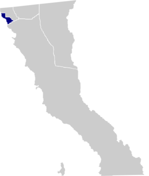
motto="Horizonte de Posibilidades"
(English: "A Horizon of Possibilities")
map_caption = Location of Playas de Rosarito in Baja California.
mapsize=150px
population_as_of=2005
population_total=73305
population_note=Data source: [http://www.inegi.gob.mx/est/contenidos/espanol/sistemas/conteo2005/localidad/iter/ INEGI]
population_density_km2=auto
area_total_km2=513.32
leader_title = Municipal president
leader_name = Hugo Torres
leader_party = PRI party
subdivision_type2 = Municipal seat
subdivision_name2 = Playas de Rosarito
subdivision_type3 = Largest city
subdivision_name3 = Playas de Rosarito
blank_name = INEGI code
blank_info = 005
timezone = PST
utc_offset = -8
timezone_DST = PDT
utc_offset_DST = -7
latd = 32 | latm = 21 | latNS = N
longd = 117 | longm = 3 | longEW = W
website=es icon [http://www.municipiodeplayasderosarito.gob.mx/ Ayuntamiento de Playas de Rosarito]
established_title=Municipality established
established_date=June 29, 1995
footnotes=Source: [http://www.e-local.gob.mx/work/templates/enciclo/bajacalifornia/municipios/02005a.htm Enciclopedia de los Municipios de México]

Playas de Rosarito is a municipality in the northwestern part of the Mexican state of Baja California. It lies just south of the city of Tijuana. Its municipal seat is the town of Playas de Rosarito. According to the 2005 census, the municipality had a population of 73,305 inhabitants. Its area is 513.32 km² (198.19 sq mi).

Major communities

*Ampliación Ejido Plan Libertador
*Colonia Santa Anita
*Ejido Morelos
*Playas de Rosarito
*Primo Tapia

References

*es icon [http://www.inegi.gob.mx/est/contenidos/espanol/sistemas/conteo2005/localidad/iter/ Link to tables of population data from the 2005 Census] , INEGI: Instituto Nacional de Estadística, Geografía e Informática.
*es icon [http://www.e-local.gob.mx/work/templates/enciclo/bajacalifornia/municipios/02005a.htm Playas de Rosarito] , " [http://www.e-local.gob.mx/wb2/ELOCAL/ELOC_Enciclopedia Enciclopedia de los Municipios de México] ", Instituto Nacional Para el Federalismo y el Desarrollo Municipal, SEGOB. Accessed on line November 15, 2007.

External links

*es icon [http://www.municipiodeplayasderosarito.gob.mx/ Ayuntamiento de Playas de Rosarito] Official government website.


Wikimedia Foundation. 2010.

Игры ⚽ Поможем написать курсовую

Look at other dictionaries:

  • Playas de Rosarito, Baja California — Infobox Settlement name = Playas de Rosarito settlement type = City native name = nickname = motto = Horizonte de Posibilidades (English: A Horizon of Possibilities ) imagesize = image caption = image image shield = mapsize = 200px map caption =… …   Wikipedia

  • Rosarito Beach Municipality — Rosarito Beach Muncipality   Municipality   Municipio de Playas de Rosarito Municipality of Rosarito Beach …   Wikipedia

  • Playas de Tijuana — Infobox Settlement official name = Municipal Borough Playas de Tijuana native name = Delegacion Municipal Playas de Tijuana nickname = Playas , sister republic of Playas motto = imagesize = 220px image caption = View of the beaches image image… …   Wikipedia

  • Tijuana (municipality) — Infobox Settlement name = Tijuana settlement type = Municipality subdivision type = Country subdivision name = Mexico subdivision type1 = State subdivision name1 = Baja California image shield = escudotijuana.png map caption = Location of Tijuana …   Wikipedia

  • Municipal president of Rosarito — Presidents of the municipality of Playas de Rosarito in Baja California …   Wikipedia

  • Tijuana Municipality, Baja California — Tijuana Municipality   Municipality   Municipio de Tijuana Municipality of Tijuana …   Wikipedia

  • Baja Malibu — is a beach and resort in Playas de Rosarito Municipality, Baja California named after the beach town Malibu of Los Angeles County. The beach is a popular tourist area in the San Diego–Tijuana metropolitan region and draws surfers from all over… …   Wikipedia

  • San Diego–Tijuana — This article is about the international metropolitan region. For the cites of San Diego and Tijuana, see San Diego and Tijuana. Coordinates: 32°32′31.87″N 117°01′46.63″W /  …   Wikipedia

  • San Diego–Tijuana metropolitan area — Infobox American International Metropolitan Area metropolitan name = San Diego–Tijuana metropolitan area name = San Diego Tijuana largest city = flagicon|USA San Diego, CA flagicon|MEX Tijuana, BC other cities = San Diego Chula Vista Oceanside… …   Wikipedia

  • Baja California — Infobox Settlement name = Baja California other name = native name = Estado Libre y Soberano de Baja California nickname = settlement type = State motto = imagesize = image caption = flag size = 140px image seal size = image shield = Escudo Baja… …   Wikipedia

Share the article and excerpts

Direct link
Do a right-click on the link above
and select “Copy Link”