- Playas de Tijuana
Infobox Settlement
official_name = Municipal Borough Playas de Tijuana
native_name = "Delegacion Municipal Playas de Tijuana"
nickname = "Playas", "sister republic of Playas"
motto =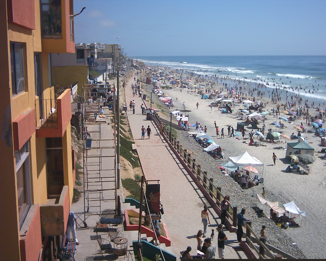
imagesize = 220px
image_caption = View of the beaches
image_
image_shield =
mapsize =
map_caption =
pushpin_
subdivision_type =
subdivision_name =
subdivision_type1 = State
subdivision_name1 =
subdivision_type2 =Municipality
subdivision_name2 = Tijuana
subdivision_type3 =Borough
subdivision_name3 = Delegacion Playas de Tijuana
government_type = Delegacion
leader_title = Municipal Delegate
leader_name = Manuel González Reyes
leader_title1 = Secretary General
leader_name1 = Jose Esteban Hernandez Cueva
leader_title2 =
leader_name2 =
leader_title3 =
leader_name3 =
established_title =
established_date =
established_title2 =
established_date2 =
established_title3 =
established_date3 =
area_magnitude =
unit_pref = Metric
postal_code = 22500
website = es [http://www.tijuana.gob.mx/Delegaciones/Delegaciones.asp?delegacion=6 Playas de Tijuana]Playas de Tijuana (Spanish for "beaches of
Tijuana ") is the westernmostborough of themunicipality of Tijuana ,Baja California .Location
The
borough of Playas de Tijuana is located in the city ofTijuana , bordered by thePacific Ocean to the west, theUnited States to the north, the municipality of Playas de Rosarito to the south and the boroughs Centro to the Northeast andSan Antonio de los Buenos to the East.Popularly, the borough itself is known as the "Sister
Republic of Playas", due to its location and geographic isolation from the rest of the city; also as "Playas-Herzegovina" for all the military roadblocks and checkpoints (citations needed), and also known to the locals and surfers, but to a lesser extent, as "turd beach" because of sewage contamination on the beach.Administration
Its administration or government relies on a Municipal Delegate, or "Delegado Municipal" es, who is appointed by the Municipal President of Tijuana.
ervice Departments
The "delegacion" (Spanish for borough) is in charge of the following services:
*Urban Planning:
**Construction permissions
**Land usage authorization & certification
*Civil Registry:
**Marriage certifications
**Defunction certificates
**Birth certificates
*Inspection and Verification:
**Request of various certificates
**Citizen reports
*Public Works:
**Maintenance of street lights
**Street paving
**Street maintenance
*Community Development:
**Housing support (incentives for house acquisition)
**Scholarships (various types)Entertainment & Culture
This is where the beaches of Tijuana are located (hence the name) and it is also one of the two exits to the south towards Rosarito and Ensenada. The Paseo Ensenada is a popular place for meeting and passing free time, and where major commercial centres and businesses are located. Plaza Coronado, which is located at the beginning of Paseo Ensenada, is the major entertainment centre, where mainly young people gather every day to spend free time. Water sports such as
surfing ,bodyboarding , andkayaking are available. The The Monumentall bullfighting ring of Tijuana [http://www.plazamonumental.com/tijuana.ssp Plaza Monumental] ] is located here as well as the Tijuana-campus of theUniversidad Iberoamericana [http://www.tij.uia.mx/ Universidad Iberoamericana] .] .Playas de Tijuana has its own Arts & Culture House, which has many local and artistic offers, such a
ballet school, a drawing school, painting school, dancing school, and many others. The Arts & Culture House is located inside the complex where the local government building is, and also inside the complex there is another smaller bullfight ring, known as the "Cortijo San Jose", which sometimes hostsrodeo shows. Along with the administration buildings, the House, and the "Cortijo", there is a civic square where everyseptember 15 is held the independence celebration.Federal Highway 1-D starts just south of this borough towards
Rosarito andEnsenada .Residential services
Playas de Tijuana has a good offer of hotels, residences, and places to live, either temporarily or permanently. Such places include the Park Towers [http://www.parktowersbythesea.com Park Towers] .] , the "Real del Mar" residential development (which includes within a
Residence Inn by Marriott ) [http://www.marriott.com/hotels/travel/tijri-residence-inn-baja-california-tijuana-real-del-mar/ Residence Inn by Marriott - Real del Mar] .] , the "Playas Diamante" residential [http://www.playasdiamante.com Playas Diamante] .] , "La Perla Tijuana" [http://www.bcba.com.mx/minisitios/laperlatijuana/index.cfm?lang=2 La Perla Tijuana] .] , "La Cuspide Residencial"es [http://www.lacuspideresidencial.com La Cuspide Residencial] .] , the "Puesta del Sol" [http://www.puestadelsol.com.mx Puesta del Sol] .] residential, es [http://www.aquaresidential.com?delegacion=6 AQUA Residential,] and many other places.Playas has been recently experiencing mid/high-rise building growth. The 27-storey high
Trump Ocean Resort Baja Mexico is being built in Playas de Tijuana, along with the 17-storey high Park Towers complex, with four towers proyected. Many other low-rise buildings, ranging from 5+ storeys are found throughout Playas.Hotels in Playas de Tijuana
Dali Suites is located in the community of playas de tijuana, it's a quiet, simple, clean and very friendly hotel, 14 exclusive suites with free wireless internet, the "Dali Suites" lodging [http://www.dalisuites.com Playas De Tijuana] .]
Transportation
Playas, as it is the westermost and thus the last portion in Tijuana, is linked to the rest of the city by the following two "Azul y Blanco" bus routes:
*Playas 1-Soler-Centro-Correo-Plaza Rio-Palacio-Postal (runs along one of Playas's main avenues, Paseo Ensenada)
*Playas 2-Soler-Centro-Linea-Palacio-Hospital-Buena Vista-Central Camionera (runs along one of Playas's main avenues, Paseo Pedregal)Playas is also linked to the rest of the city served by the following three fixed-route taxi lines:
*Playas 1 (similar to "Azul y Blanco" bus route 1)
*Playas 2 (similar to "Azul y Blanco" bus route 2)
*Playas 3 (reduced frequencies)References
External links
* [http://www.tijuana.gob.mx/Delegaciones/Delegaciones.asp?delegacion=6 Borough of Playas de Tijuana]
* [http://www.aquaresidential.com?delegacion=6 AQUA Residential]
Wikimedia Foundation. 2010.