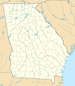
- Clyattville, Georgia
-
Clyattville — Unincorporated town — Location within the state of Georgia Coordinates: 30°41′29″N 83°18′55″W / 30.69139°N 83.31528°WCoordinates: 30°41′29″N 83°18′55″W / 30.69139°N 83.31528°W Country United States State Georgia County Lowndes Time zone Eastern (EST) (UTC-5) – Summer (DST) EDT (UTC-4) ZIP codes FIPS code GNIS feature ID Clyattville is an unincorporated town in Lowndes County, Georgia, United States.[1]
Contents
Geography
It is located approximately 6.5 miles southeast of Valdosta.
School
Clyattville Elementary School is located in the Clyattville area. It belongs to the Lowndes County School System.
History
When Clyattville was first settled, there were only a few families to establish residence. Some of the families were the following: the Brays, the Hunters, the Lanes, the Arnolds, the Covingtons, the Quillians, and of course, the Clyatts. It was reported that Clyattville was named after the Clyatt family since they were the first settlers.
The community has not always been at its present site. Once it was located two miles northwest on the Old Clyattville Rd. It was said that the reason for moving the original location was the fact that a railroad was constructed through the community which caused to much noise. The first train that ran through Clyattville was known as the Coast Line.
The first store in Clyattville was owned by the Bray family. Since that time, several stores have been established. Some were and are; Zipperer's Grocery (located across the street from the Clyattville Elementary School), a Minit-Mart, now a Holiday Market, (on the Lake Park-Clyattville Highway), J.W.'s Grocery (located on the Madison Highway), Clyattville 66 (located at the corner of the Madison Highway and the Lake Park-Clyattville Highway). There once was a grist mill, a cotton gin, a drug store, and only one church, the Methodist Church.
In the early stages of the settlement of Clyattville, it was mainly an agricultural region. In the early 1950s, Owens Illinois built a paper mill and bag plant. Before the paper mill was constructed, the community thrived on farming. There was a cotton gin which was owned by Mr. C.A. Baucom.
The people had to travel by buggies or wagon until one could afford a car. The first person to own a car in Clyattville was Dr. Quillian. His office was a wooden building in Olympia (the old saw mill by the river) at the railroad track.
Clyattville is definitely a community that has changed since the times of their fore-fathers. One cannot say that Clyattville is an area that is continuously increasing in population or undergoing industrial changes.
References
- ^ "US Gazetteer files: 2010, 2000, and 1990". United States Census Bureau. 2011-02-12. http://www.census.gov/geo/www/gazetteer/gazette.html. Retrieved 2011-04-23.
External links
Municipalities and communities of Lowndes County, Georgia Cities Town CDP Unincorporated
communitiesClyattville | Naylor
Categories:- Unincorporated communities in Georgia (U.S. state)
- Populated places in Lowndes County, Georgia
- Valdosta metropolitan area
Wikimedia Foundation. 2010.


