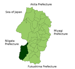
- Oguni, Yamagata
-
Oguni
小国町— Town —
FlagLocation of Oguni in Yamagata Prefecture Coordinates: 38°4′N 139°45′E / 38.067°N 139.75°ECoordinates: 38°4′N 139°45′E / 38.067°N 139.75°E Country Japan Region Tōhoku Prefecture Yamagata Prefecture District Nishiokitama District Area - Total 737.55 km2 (284.8 sq mi) Population (February 1, 2008) - Total 9,342 - Density 12.7/km2 (32.8/sq mi) Time zone Japan Standard Time (UTC+9) City symbols - Tree Beech - Flower Sakura - Bird Japanese Bush-warbler Phone number 0238-62-2111 Address 2-70 Ogunikosaka, Oguni-chō, Yamagata-ken
999-1363Website Town of Oguni This article is about the town in Yamagata Prefecture. There are towns in other prefectures with the same name, see Oguni, Kumamoto and Oguni, Niigata.Oguni (小国町 Oguni-machi) is a town located in Nishiokitama District, Yamagata, Japan.
As of February 1, 2008, the town has an estimated population of 9,342 and a density of 12.7 persons per km². The total area is 737.55 km².
Contents
Transportation
Train stations
Major roads
- Route 113
External links
 Media related to Oguni, Yamagata at Wikimedia Commons
- Oguni official website (Japanese)
 Yamagata Prefecture
Cities 
Akumi Higashimurayama Higashiokitama Higashitagawa Kitamurayama Mogami Nishimurayama Nishiokitama Categories:- Towns in Yamagata Prefecture
- Yamagata geography stubs
Wikimedia Foundation. 2010.


