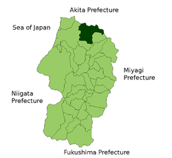
- Mamurogawa, Yamagata
-
Mamurogawa
真室川町— Town — Location of Mamurogawa in Yamagata Prefecture Coordinates: 38°51′N 140°15′E / 38.85°N 140.25°ECoordinates: 38°51′N 140°15′E / 38.85°N 140.25°E Country Japan Region Tōhoku Prefecture Yamagata Prefecture District Mogami Area – Total 374.29 km2 (144.5 sq mi) Population (2003) – Total 10,099 – Density 27/km2 (69.9/sq mi) Time zone Japan Standard Time (UTC+9) Website Town of Mamurogawa Mamurogawa (真室川町 Mamurogawa-machi) is a town located in Mogami District, Yamagata, Japan.
As of 2003, the town has an estimated population of 10,099 and a population density of 26.98 persons per km². The total area is 374.29 km².
Contents
Transportation
Train stations
- Ōu Main Line: Mamurogawa - Kamabuchi - Ōtaki - Nozoki
Major roads
- Tōhoku Chūō Expressway: Mamurogawa interchange
- Route 13, Route 344
External links
 Media related to Mamurogawa, Yamagata at Wikimedia Commons
- Mamurogawa official website (Japanese)
Categories:- Towns in Yamagata Prefecture
- Yamagata geography stubs
Wikimedia Foundation. 2010.


