- M-227 (Michigan highway)
-
M-227 
Route information Maintained by MDOT Length: 6.688 mi[2] (10.763 km) Existed: October 1, 1998[1] – present Major junctions South end:  I-69 south of Marshall
North end:  BL I-94 in Marshall
Location Counties: Calhoun Highway system Michigan State Trunkline Highway System
Interstate • US • State←  US 223
M-231  →
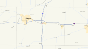
→M-227 is a 6.668-mile (10.731 km) north–south state trunkline highway in the U.S. state of Michigan. It consists largely of a segment of old U.S. Highway 27 (US 27) along the south and west sides of Marshall. The highway passes the airport and serves an industrial section of town north of the Kalamazoo River. M-227 was created as a part of a program to add additional routes into the state's highway system under the leadership of Governor John Engler.
Contents
Route description
M-227 starts at a diamond interchange with Interstate 69 (I-69) at exit 32 between Tekonsha and Marshall. From I-69, M-227 runs east on F Drive South north of Pine and Long lakes for approximately one mile (1.6 km). The highway runs through agricultural land and turns north to follow Old US 27/17 Mile Road. At Division Drive, M-227 passes into Marshall on Kalamazoo Avenue. The highway runs past the Brooks Field airport and the Alwin Downs Golf Course. Kalamazoo Avenue crosses the Kalamazoo River, and M-227 turns west along Industrial Road. This section of town is an industrial park, and M-227 curves north onto West Drive,[3][4] crossing the Norfolk Southern Railroad.[5] The northern terminus is BL I-94 (Michigan Avenue) on the west side of Marshall, near I-69.[3] It lies only within Calhoun County and is entirely an undivided surface route.[4]
History
Before the completion of I-69 near Marshall in late 1967, US 27 followed 17 Mile Road and Kalamazoo Avenue into Marshall. That routing was turned back to local control after the completion of I-69 to I-94.[6][7] It came into existence nearly thirty-five years after the completion of I-69 in southern Michigan and, except for the section of old US 27, was long a collection of unnumbered local surface roads. It was designated as a part of Governor John Engler's Rationalization program on October 1, 1998 and first signed in 2001.[1][8]
Major intersections
The entire highway is in Calhoun County.
Location Mile[2] Destinations Notes Fredonia Township 0.000  I-69 – Coldwater, Lansing
Exit 32 on I-69 Marshall 6.688  BL I-94
1.000 mi = 1.609 km; 1.000 km = 0.621 mi References
- ^ a b "MDOT Accepts Responsibility for 120 Miles of Local Roads" (Press release). Michigan Department of Transportation. September 24, 1998. http://www.michigan.gov/mdot/0,1607,7-151-9620_11057-94859--,00.html. Retrieved August 26, 2008.
- ^ a b Michigan Department of Transportation (2001). Control Section/Physical Reference Atlas (Map). http://mdotwas1.mdot.state.mi.us/public/maps/pr/. Retrieved January 25, 2008.
- ^ a b Michigan Department of Transportation (2010). Official Department of Transportation Map (Map). 1 in:15 mi/1 cm:9 km. Section M10.
- ^ a b Google, Inc. Google Maps – Overview Map of M-227 (Map). Cartography by Google, Inc. http://maps.google.com/maps?f=d&source=s_d&saddr=M-227+N%2FF-Drive+S&daddr=42.235381,-84.9632943+to:42.26667,-84.97272+to:West+Dr+S&hl=en&geocode=FQb4gwIdHEvv-g%3BFfV1hAIdIpDv-ikXCuQrXeIXiDGoyNOc9x6EYg%3BFS7whAIdUGvv-in9x_Mn3eIXiDHL2ydpqlViVQ%3BFW0BhQId6D_v-g&mra=dme&mrcr=0&mrsp=3&sz=15&via=1,2&sll=42.27045,-84.981995&sspn=0.03001,0.029097&ie=UTF8&ll=42.242625,-84.974957&spn=0.120092,0.116386&t=h&z=13. Retrieved September 29, 2010.
- ^ Michigan Department of Transportation (April 2009). Michigan's Railroad System (Map). http://www.michigan.gov/documents/MDOT_Official_Rail_130897_7.pdf. Retrieved September 14, 2010.
- ^ Michigan Department of State Highways (1967). Official Highway Map (Map). Section M10.
- ^ Michigan Department of State Highways (1968). Official Highway Map (Map). Section M10.
- ^ Michigan Department of Transportation (2001). Official Department of Transportation Map (Map). 1 in:14.5 mi/1 cm:9 km. Section M10.
External links
Categories:- State highways in Michigan
- Transportation in Calhoun County, Michigan
Wikimedia Foundation. 2010.

