- New York State Route 276
-
NYS Route 276
Route information Maintained by NYSDOT Length: 4.69 mi[3] (7.55 km) Existed: ca. 1963[1][2] – present Major junctions West end:  US 11 in Champlain
 Route 221 at Quebec border
East end: US 11 in Rouses PointLocation Counties: Clinton Highway system Numbered highways in New York
Interstate • U.S. • N.Y. (former) • Reference • County←  NY 275
NY 277  →
→New York State Route 276 (NY 276) is a state highway located entirely within Clinton County, New York, in the United States. It connects the town of Champlain to the village of Rouses Point, with both termini situated at intersections with U.S. Route 11 about 5 miles (8 km) apart. The middle third of the route runs along the southern edge of the Canadian border and connects to Quebec Route 221 by way of a border crossing midway between the villages of Champlain and Rouses Point. In Rouses Point, NY 276 is known as Church Street and Platt Street. All of NY 276 was originally designated as part of NY 348 before gaining its current designation ca. 1963.
Contents
Route description
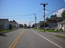 NY 276 eastbound at the junction of Church and Pratt Streets in Rouses Point
NY 276 begins at an intersection with U.S. Route 11 (US 11) east of the village of Champlain in the town of the same name. The route heads northeast for 2 miles (3.2 km) through open fields to the Canadian border, where it intersects the de facto southern terminus of Quebec Route 221. Instead of continuing into Quebec, NY 276 turns east, running along the southern edge for the border for just over 1 mile (1.6 km) before turning south toward the village of Rouses Point. The amount of development along the route increases as it enters the village on Church Street.[4]
At Pratt Street, the first cross street that NY 276 meets in Rouses Point, the route turns eastward, following Pratt Street toward the center of the village. After one block, the route crosses the Delaware and Hudson Railroad and serves Rouses Point's Amtrak station at the junction of Pratt and Delaware Streets. NY 276 remains on Pratt Street for another two blocks to the commercial center of the village, where it terminates at a junction with US 11 (Lake Street) on the shores of Lake Champlain.[4] NY 276 serves as a truck route for traffic on US 11 as it bypasses a low-clearance railroad overpass on US 11 south of the village.[5]
History
The portion of modern NY 276 east of the Canadian border crossing in the town of Champlain was originally designated as part of Route 22, an unsigned legislative route, by the New York State Legislature in 1908.[6][7] It did not receive a signed designation until ca. 1931 when the entirety of what is now NY 276 became part of NY 348, which continued south from the current west end of NY 276 to the Chazy hamlet of West Chazy via modern U.S. Route 11 (US 11), U.S. Route 9, and County Route 24.[8][9] NY 348 was truncated southward to the hamlet of Chazy ca. 1963, eliminating a lengthy overlap with US 9. The former alignment of NY 348 north of US 11 was renumbered to NY 276.[1][2]
Major intersections
The entire route is in Clinton County.
Location Mile[3] Destinations Notes Town of Champlain 0.00 US 112.02 Route 221Southern terminus of Route 221 Rouses Point 4.69 US 111.000 mi = 1.609 km; 1.000 km = 0.621 mi References
- ^ a b Esso (1962). New York with Sight-Seeing Guide (Map). Cartography by General Drafting (1962 ed.).
- ^ a b Esso (1963). New York Happy Motoring Guide (Map). Cartography by General Drafting (1963 ed.).
- ^ a b "2008 Traffic Volume Report for New York State" (PDF). New York State Department of Transportation. June 16, 2009. p. 203. https://www.nysdot.gov/divisions/engineering/technical-services/hds-respository/NYSDOT%20TVR%202008%20by%20Route.pdf. Retrieved February 1, 2010.
- ^ a b Yahoo! Inc. Yahoo! Maps – overview map of NY 276 (Map). Cartography by NAVTEQ. http://maps.yahoo.com/#mvt=h&lat=44.996448&lon=-73.39063&zoom=15&q1=44.982759%2C-73.416225&q2=45.009852%2C-73.400089&q3=44.994824%2C-73.364995. Retrieved May 30, 2010.
- ^ "Oversize / Overweight Vehicle Pre-Screening Tool". New York State Department of Transportation. https://www.nysdot.gov/gisapps/osowscreen. Retrieved May 31, 2010.
- ^ State of New York Department of Highways (1909). The Highway Law. Albany, New York: J. B. Lyon Company. p. 61. http://books.google.com/books?id=jZ0AAAAAMAAJ&pg=PA61. Retrieved May 30, 2010.
- ^ New York State Department of Highways (1920). Report of the State Commissioner of Highways. Albany, New York: J. B. Lyon Company. p. 532. http://books.google.com/books?id=Sj4CAAAAYAAJ&pg=PA532. Retrieved May 30, 2010.
- ^ Standard Oil Company of New York (1930). Road Map of New York (Map). Cartography by General Drafting.
- ^ Kendall Refining Company (1931). New York (Map). Cartography by H.M. Gousha Company.
External links
Categories:- State highways in New York
- Transportation in Clinton County, New York


Wikimedia Foundation. 2010.