- New York State Route 157
-
NYS Route 157 Route information Maintained by NYSDOT Length: 9.24 mi[2] (14.87 km) Existed: 1930[1] – present Major junctions West end:  NY 156 in Berne
East end:  NY 85 in New Scotland
Location Counties: Albany Highway system Numbered highways in New York
Interstate • U.S. • N.Y. (former) • Reference • County←  NY 156
NY 157A  →
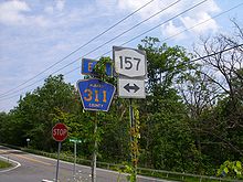
→New York State Route 157 (NY 157) is a state highway in Albany County, New York, in the United States. It runs from an intersection with NY 156 near the hamlet of Berne to a junction with NY 85 in the hamlet of New Salem. NY 157 is a two-lane, narrow, winding route that runs along an escarpment overlooking the Capital District. The route provides access to John Boyd Thacher State Park and Thompson's Lake State Park. NY 157 was assigned to its current alignment as part of the 1930 renumbering of state highways in New York.
Contents
Route description
Route 157 begins at an intersection with NY 156 in Berne. The highway heads to the southeast, running along parts of the rural regions of Albany County. Route 157, known as Thompson's Lake Road, turns to the south and nears Thompson's Lake. Intersecting with Albany County Route 256 (Ketcham Road), the highway passes the state park of Thompson's Lake, intersecting with local roads in the entire segment. The route then passes through the hamlet of Thompson's Lake and turns northward at an intersection with County Route 303 (Beaver Dam Road), which is a continuation of NY 157/Thompson's Lake Road.[3]
Route 157 heads northward, intersecting with the other terminus of County Route 256 and begins to head eastward. The road is now known as Thacher Park Road, passing large forests for the entire way. Beaver Dam Road, now County Route 311, merges into Route 157 on a turn southward. Just after the merge, Route 157 turns southward and terminates at an intersection with NY 85 (New Scotland Road).[3]
History
In 1908, the New York State Legislature created Route 7, an unsigned legislative route extending from Binghamton to Albany via Oneonta, and Schoharie. In western Albany County, Route 7 utilized what is now NY 443 from the Schoharie County line to East Berne, where it turned north to follow Thatcher Park Road (now NY 910J and NY 157A) to Thompson's Lake. From there, it continued eastward on modern NY 157 to its terminus at NY 85, at which point Route 7 continued northeastward on current NY 85 toward Albany.[4][5] The segment of legislative Route 7 between Thompson's Lake and New Scotland Road was not assigned a posted designation until the 1930 renumbering of state highways in New York when it became part of the new NY 157, which continued west from Thompson's Lake to NY 146 (now NY 156) southwest of Altamont.[1]
NY 157A
NY 157A (5.88 miles or 9.46 kilometres) is a two-laned loop off of NY 157 in Berne that veers to the south to serve the hamlet of East Berne and nearby Warner Lake. At East Berne, it connects to NY 443 via Thacher Lake Road (designated NY 910J, an unsigned reference route).[2] The route was assigned in the early 1930s.[1][6]
Major intersections
The entire route is in Albany County.
Location Mile[2] Destinations Notes Berne 0.00  NY 156
0.61  NY 157A
Western terminus of NY 157A Thompson's Lake State Park Main entrance 3.54  NY 157A
Eastern terminus of NY 157A John Boyd Thacher State Park Main entrance New Scotland 9.24  NY 85
NY 85Hamlet of New Salem 1.000 mi = 1.609 km; 1.000 km = 0.621 mi References
- ^ a b c Standard Oil Company of New York (1930). Road Map of New York (Map). Cartography by General Drafting.
- ^ a b c "2008 Traffic Volume Report for New York State" (PDF). New York State Department of Transportation. June 16, 2009. pp. 174–175. https://www.nysdot.gov/divisions/engineering/technical-services/hds-respository/NYSDOT%20TVR%202008%20by%20Route.pdf. Retrieved January 31, 2010.
- ^ a b Yahoo! Inc. Yahoo! Maps – overview map of NY 157 (Map). Cartography by NAVTEQ. http://maps.yahoo.com/#mvt=m&lat=42.6502&lon=-74.037829&zoom=15&q1=42.614932%2C-73.975258&q2=42.67674%2C-74.077826&q3=42.676992%2C-74.07774&w0=42.642167067064676%2C-74.04321670532226&w1. Retrieved June 15, 2008.
- ^ State of New York Department of Highways (1909). The Highway Law. Albany, New York: J. B. Lyon Company. p. 57. http://books.google.com/books?id=jZ0AAAAAMAAJ&pg=PA57. Retrieved July 13, 2010.
- ^ New York State Department of Highways (1920). Report of the State Commissioner of Highways. Albany, New York: J. B. Lyon Company. pp. 513–515. http://books.google.com/books?id=Sj4CAAAAYAAJ&pg=PA513. Retrieved July 13, 2010.
- ^ Texas Oil Company (1932). Texaco Road Map – New York (Map). Cartography by Rand McNally and Company.
External links
Categories:- State highways in New York
- Transportation in Albany County, New York
Wikimedia Foundation. 2010.


