- County Route 506 (New Jersey)
-
County Route 506
Route information Length: 10.74 mi[1] (17.28 km) Major junctions West end:  Route 159 in Fairfield
 CR 527 in Caldwell

 Route 23 / CR 577 in Verona
 CR 509 in Bloomfield
 G.S. Pkwy. in Bloomfield
 Route 7 in Belleville
East end:  Route 7 / Route 21 in Belleville
Highway system County routes in New Jersey
500-series←  CR 505
CR 507  →
→←  US 9
US 9
US 9W  →
→County Route 506 is a county highway in the U.S. state of New Jersey. The highway extends 10.74 miles (17.28 kilometers) from Oak Road (Route 159) in Fairfield to Route 7 at the Passaic River in Belleville.
Contents
Route description
CR 506 begins at an intersection with Route 159 in Fairfield Township. The route heads east-southeast as a four-lane divided highway called Bloomfield Avenue, which becomes an undivided road by the first intersection.[1] Just after crossing the town line into West Caldwell, CR 506 becomes a divided highway again, and intersects with local roads as it passes suburban areas of homes and businesses.[1][2] After the intersection with Distler Avenue, the road briefly becomes undivided. Becoming a divided highway, the route crosses over CR 613 Spur and CR 613. The divided highway ends again as CR 506 turns more to the southeast before coming to CR 633. Prior to this intersection, the road is a divided highway.[1]
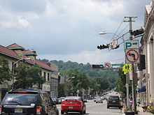
Following this intersection, the route briefly forms the border between Caldwell to the south and West Caldwell to the north before fully entering Caldwell.[1] In Caldwell, CR 506 heads southeast into the commercial downtown and intersects CR 631 before meeting CR 527. At this point, CR 527 forms a concurrency with CR 506 and the road makes a turn to the east out of the downtown through more commercial development.[1][2] The two routes split before CR 506 enters North Caldwell. The road briefly runs through North Caldwell, intersection CR 673 before it comes into Verona.[1] In Verona, the road passes more businesses and has junctions with CR 637, CR 639, and CR 636.[1][2] Before leaving Verona, Route 23 heads north from the northern terminus of CR 577 at CR 506.[1] After this intersection, CR 506 continues into Montclair and makes a turn to the south into residential areas. After a curve to the southeast, the route enters downtown Montclair and intersects CR 621 and CR 623/CR 668. The road crosses New Jersey Transit’s Montclair-Boonton Line near the Bay Street station before coming into Glen Ridge.[1][2] In Glen Ridge, CR 506 splits from Bloomfield Avenue, which continues southeast as CR 506 Spur.[1]
At this point, CR 506 turns north onto Highland Avenue briefly before turning east onto Belleville Avenue.[1] The road passes through wooded residential areas, intersecting CR 653 before crossing into Bloomfield. Here, the route passes homes and businesses, crossing CR 509 and CR 652.[1][2] After this, the road comes to a partial interchange with the Garden State Parkway that provides access to and from the northbound direction of the parkway.[1] Following this interchange, CR 506 passes more development as it heads into Belleville. In Belleville, the road passes homes and parkland, crossing CR 645. Entering more dense neighborhoods, CR 506 reaches Route 7, and turns north to run concurrent with that route, passing businesses.[1][2] A block later, CR 506 splits from Route 7 by heading east on Rutgers Avenue.[1] After passing some commercial establishments, CR 506 reaches an interchange with the Route 21 freeway, where the county route ends and the road continues east as a separate segment of Route 7.[1][2]
History
 Route 9 (former designation)
The current alignment of County Route 506 was legislated as part of Route 9 in the 1927 New Jersey state highway renumbering, which was to run from Pine Brook southeast to Belleville.[3][4] Route 9 was eventually removed from the state highway system, and when the 500-series county routes were created in 1952, County Route 506 was designated to run from Route 6/U.S. Route 46 (now Route 159) in Fairfield to U.S. Route 1/9 Truck in Jersey City, following Route 7 between Belleville and Jersey City. Eventually, County Route 506 was removed from the portion of road that ran concurrent with Route 7, ending at Route 7 and Route 21 in Belleville instead.[5][6]
In 2009 as part of the American Recovery and Reinvestment Act, work started on the improved bus service on Bloomfield Avenue in Bloomfield and Newark. The $2 million project includes new bus shelters, signaling priority, and express bus service to Newark Liberty International Airport and Downtown Newark.[7]
Major intersections
The entire route is in Essex County.
Location Mile[1] Destinations Notes Fairfield Township 0.00 Route 159 (Oak Road)Western terminus Caldwell 2.63 CR 527 south (Roseland Avenue)West end of CR 527 overlap 3.26 CR 527 north (Mountain Avenue)East end of CR 527 overlap Verona Township 5.22 Route 23 north (Pompton Avenue) / CR 577 south (Mt. Prospect Avenue)Glen Ridge 7.24 
 CR 506 Spur east
Bloomfield 7.89 CR 509 (Broad Street)8.27 G.S. Pkwy. northGSP exit 149 Belleville 10.39 Route 7 south (Washington Avenue)West end of NJ 7 overlap 10.48 Route 7 north (Washington Avenue)East end of NJ 7 overlap 10.73 Route 21NJ 21 exit 6 10.74 Route 7 east (Belleville Turnpike)Eastern terminus 1.000 mi = 1.609 km; 1.000 km = 0.621 mi Bannered routes

County Route 506 Spur
Location: Glen Ridge - Newark Length: 4.30 mi[8] (6.92 km) County Route 506 Spur is an extension of CR 506, located entirely in Essex County. The route is the continuation of Bloomfield Avenue, and extends 4.30 miles (6.92 kilometers) from Highland Avenue in Glen Ridge to McCarter Highway (Route 21) in Newark.[8]
See also
 U.S. Roads portal
 New Jersey portal
References
- ^ a b c d e f g h i j k l m n o p q r "CR 506 straight line diagram" (PDF). New Jersey Department of Transportation. http://www.state.nj.us/transportation/refdata/sldiag/00000506__-.pdf. Retrieved 2010-03-18.
- ^ a b c d e f g Google, Inc. Google Maps – overview of County Route 506 (Map). Cartography by Google, Inc. http://maps.google.com/maps?f=d&source=s_d&saddr=40.857562,+-74.31719&daddr=Bloomfield+Ave%2FRte+506+to:Belleville+Ave%2FRte+506+to:rutgers+street+and+main+street+belleville,+nj&geocode=FdpvbwIdegKS-w%3BFbL_bgIdfCyT-w%3BFYSDbgIdABaU-w%3BFThbbgIde5WU-ylXt0vCt1XCiTF-0EYTwL5l8Q&hl=en&mra=ls&via=1,2&sll=40.794383,-74.17119&sspn=0.025797,0.0842&ie=UTF8&t=h&z=12. Retrieved 2010-03-18.
- ^ Alpert, Steve. "New Jersey Roads – NJ State Highways – 5-10". Alps’ Roads. http://www.alpsroads.net/roads/nj/log/1.html#9. Retrieved 2009-03-13.
- ^ Williams, Jimmy and Sharon. "1927 New Jersey Road Map". 1920s New Jersey Highways. http://www.jimmyandsharonwilliams.com/njroads/1920s/images/1927_routes.gif. Retrieved 2008-10-08.
- ^ Alpert, Steve. "New Jersey Roads – NJ State Highways – CR 200-514". Alps’ Roads. http://www.alpsroads.net/roads/nj/log/51.html#506. Retrieved 2008-11-12.
- ^ Rutgers University Cartography Services (1965). Hudson County Road Map – Sheet 2 (Map). http://mapmaker.rutgers.edu/HUDSON_COUNTY/HudsonCountyHighway_2_1965.gif. Retrieved 2008-11-12.
- ^ http://www.njtransit.com/tm/tm_servlet.srv?hdnPageAction=PressReleaseTo&PRESS_RELEASE_ID=2507
- ^ a b NJDOT County Route 506 Spur Straight Line Diagram from the New Jersey Department of Transportation
External links
Categories:- County routes in New Jersey
- Transportation in Essex County, New Jersey
- Montclair, New Jersey


Wikimedia Foundation. 2010.