- U.S. Route 1/9 Truck
-
U.S. Route 1-9 Truck

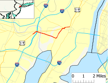
Route information Truck route of US 1/9 Maintained by New Jersey Department of Transportation Length: 4.11 mi[1] (6.61 km) Major junctions South end:  US 1/9 in Newark
 I-95 / NJ Turnpike in Newark
 Route 440 in Jersey City
 Route 7 in Jersey City
North end:  US 1/9 / Route 139 in Jersey City
Highway system United States Numbered Highways
List • Bannered • Divided • ReplacedNew Jersey State Highway Routes
Interstate and USU.S. Route 1/9 Truck is a United States highway in the northern part of New Jersey that stretches 4.11 mi (6.61 km) from the eastern edge of Newark to the Tonnelle Circle in Jersey City. It is the alternate road for U.S. Route 1/9 that trucks must use because they are prohibited from using the Pulaski Skyway, which carries the main routes of U.S. Route 1/9. It also serves traffic accessing the New Jersey Turnpike, Route 440, and Route 7. The route is a four- to six-lane road its entire length, with portions of it being a divided highway, that runs through urban areas. From its south end to about halfway through Kearny, U.S. Route 1/9 Truck is freeway-standard, with access to other roads controlled by interchanges.
While the U.S. Route 1/9 Truck designation was first used in 1953, the roadway comprising the route was originally designated as an extension of pre-1927 Route 1 in 1922, a route that in its full length stretched from Trenton to Jersey City. U.S. Route 1/9 was designated along the road in 1926 and one year later, in 1927, this portion of pre-1927 Route 1 was replaced with Route 25 as well as with a portion of Route 1 north of the Communipaw Avenue intersection. Following the opening of the Pulaski Skyway in 1932, U.S. Route 1/9 and Route 25 were realigned to the new skyway. After trucks were banned from the skyway in 1934, the portion of Route 25 between Newark and Route 1 was designated as Route 25T. In 1953, U.S. Route 1/9 Truck was designated in favor of Route 25T and Route 1 along this segment of road. The portion of the truck route north of Route 7 is being rebuilt as part of a $271.9 million project to construct new approach roads to connect Route 1&9T, Route 7, the Pulaski Skyway, Route 139, and Route 1&9 north of Tonnele Circle and local streets in Jersey City. Construction, which started in late 2008, is expected to be complete in late 2012.
Contents
Route description
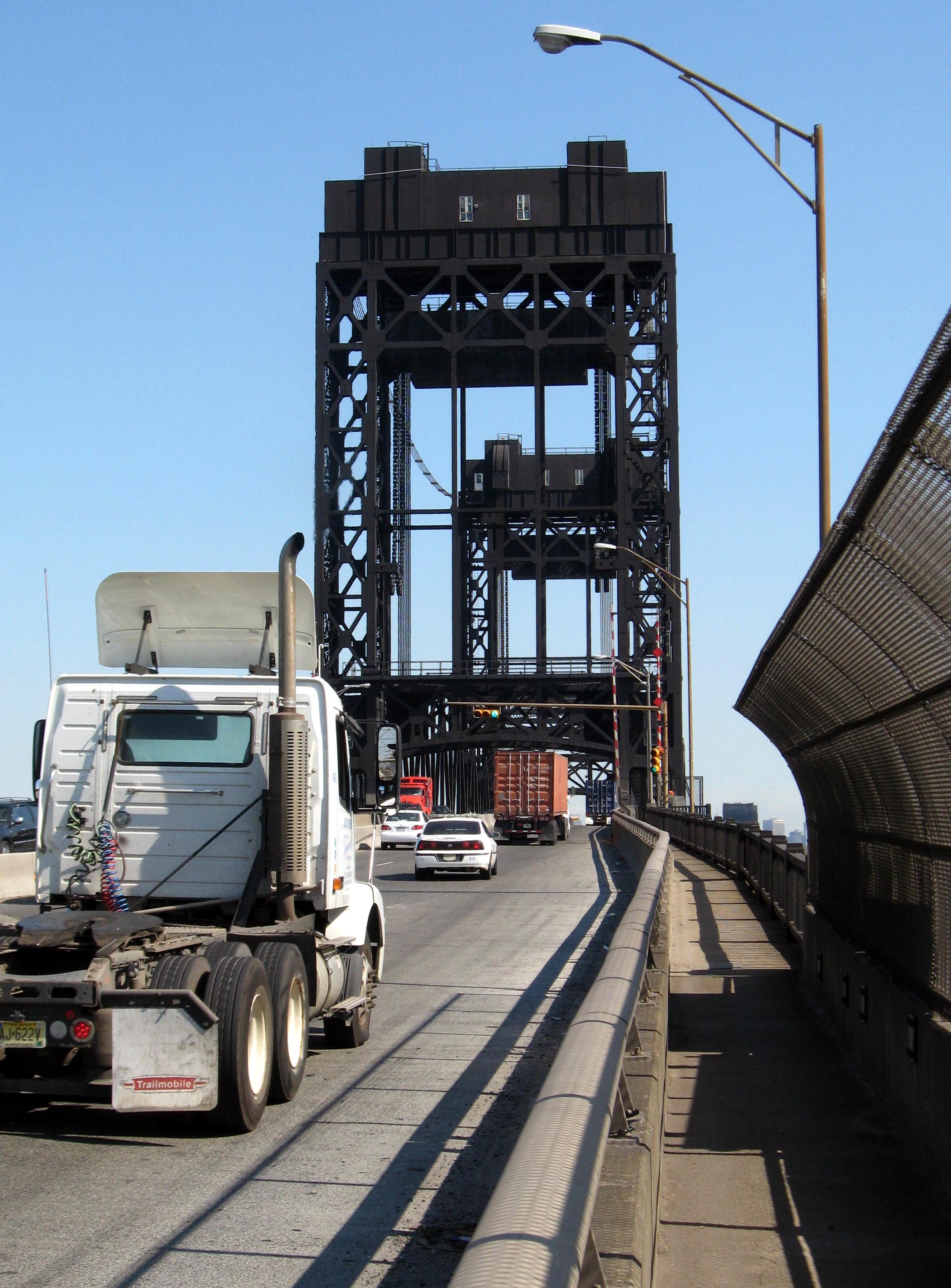
 U.S. Route 1/9 Truck crossing the Passaic River
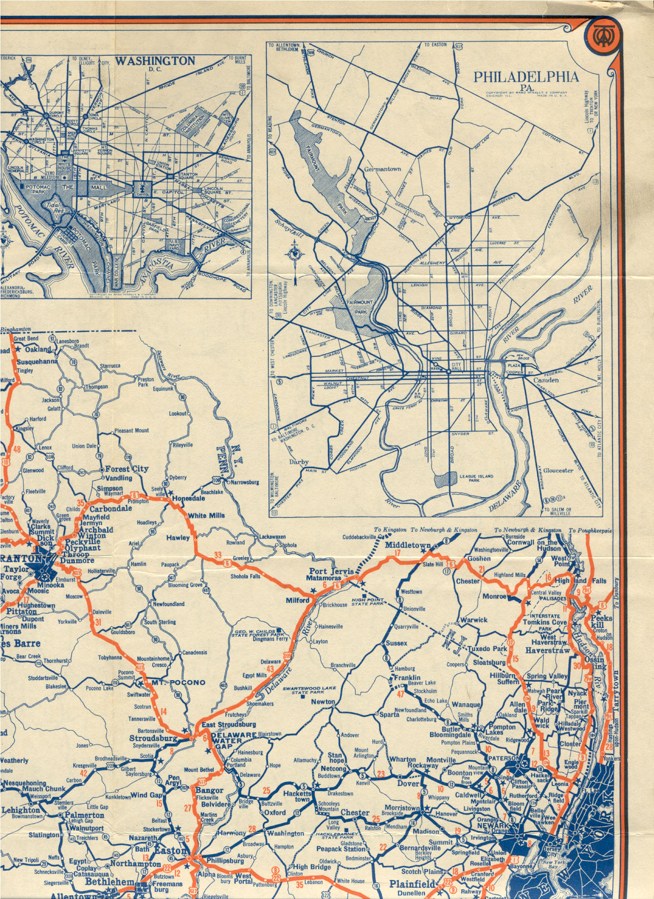
U.S. Route 1/9 Truck begins at an interchange with access to and from the southbound direction U.S. Route 1/9, the Pulaski Skyway, in the Ironbound section of the city of Newark in Essex County.[1] The truck route is meant to bypass the portion of U.S. Route 1/9 along the Pulaski Skyway, which trucks are restricted from.[2] It merges onto Raymond Boulevard, which continues west from the U.S. Route 1/9 and U.S. Route 1/9 Truck interchange into downtown Newark.[3] The truck restriction on Route 1/9 is for the "safety and welfare of the public" according to the New Jersey Department of Transportation not a specific bridge defect.[4] At this point, the truck route becomes a four-lane divided highway, heading to the east. A short distance later, the road comes to an interchange with the New Jersey Turnpike (Interstate 95) and Doremus Avenue before crossing over the Passaic River on a drawbridge.[1] Here, the route enters Kearny in Hudson County and continues east into industrial areas as the Lincoln Highway. The road has a right-in/right-out in both directions that provides access to Jacobus Avenue before it comes to an interchange with County Route 659.[1][3] From here, U.S. Route 1/9 Truck becomes a six-lane divided highway and comes to an at-grade intersection with Hackensack Avenue.[1] Past this intersection, the road crosses the Hackensack River on a drawbridge and enters Jersey City. Upon entering Jersey City, the road becomes Communipaw Avenue and intersects the northern terminus of Route 440 near the Hudson Mall.[1][3]
In anticipation of a general increase of activity in Port of New York and New Jersey and new development on West Side and Hackensack Riverfront studies are being conducted to make the intersection a multi-level traffic circle and northern and southern (Rte 440) approaches to it into a multi-use urban boulevard that includes grade separations and additional meridians.[5] [6][7][8] At this intersection, Communipaw Avenue continues to the east and U.S. Route 1/9 Truck turns to the north, becoming an unnamed four-lane undivided road.[1] bisecting Lincoln Park before coming to an intersection with County Route 605. Here, the road becomes a four-lane divided highway again, passing some urban business areas before running between wetlands to the west and Holy Name Cemetery to the east. The route heads into more commercial areas again before passing urban residences, coming to an intersection that provides access to the Pulaski Skyway. Here, U.S. Route 1/9 Truck turns east on Broadway, running through a business district. A short distance later, it turns north onto an unnamed road with County Route 642 continuing east on Broadway. The route passes under a Conrail Shared Assets Operations railroad line and PATH's Newark – World Trade Center Line before crossing under the Pulaski Skyway.[1][3] Immediately after, U.S. Route 1/9 Truck intersects the eastern terminus of Route 7 and turns to the east, with County Route 645 continuing north at this intersection.[1] The truck route becomes a four-lane undivided road that runs to the north of the Pulaski Skyway and passes through industrial sectors, crossing over a railroad line and County Route 646, known as St. Paul's Avenue, on a new viaduct that had replaced a 1928 structure. Trafic reconfiguration was completed in September 2011.[9][10][11][3] A short distance later, U.S. Route 1/9 Truck comes to the Tonnele Circle with U.S. Route 1/9 and Route 139, where it ends.[1]
History
 Route 25T (1934-1953)
 Northbound U.S. Route 1/9 at the beginning of U.S. Route 1/9 Truck in Newark, with sign noting "No Trucks" on the approach to the Pulaski Skyway.
What is now U.S. 1/9 Truck between Newark and Jersey City was originally the Newark Plank Road; in 1913 this became the first segment of the Lincoln Highway.[12] The current route of U.S. Route 1/9 Truck was designated to be an extension of pre-1927 Route 1 in 1922, a route that was to run from Trenton to Jersey City.[13] When the U.S. Highway System was established in 1926, the current truck route became a part of the U.S. Route 1/9 concurrency.[14] A year later, in the 1927 New Jersey state highway renumbering, Route 25 was designated to run along the entire length of the route along with U.S. Route 1/9 as part of its journey from the Benjamin Franklin Bridge in Camden to the Holland Tunnel in Jersey City, while Route 1 was also designated along the portion north of Communipaw Avenue in Jersey City as a part of its routing from Bayonne to Rockleigh.[15][16] Following the opening of the Pulaski Skyway in 1932, U.S. Route 1/9 and Route 25 were moved to the new bridge.[17] After trucks were banned from the Pulaski Skyway in 1934, the portion of Route 25 between Newark and Route 1 was designated as Route 25T.[18][19] In the 1953 New Jersey state highway renumbering, U.S. Route 1/9 Truck was designated to replace all of Route 25T as well as the portion of Route 1 between Route 25T and the Tonnele Circle.[20][21] Beginning in late 2008 the New Jersey Department of Transportation replaced the viaduct that carries the route over St. Paul's Avenue, which was built in 1928 and determined structurally deficient. The $271.9 million replacement, was completed in 2011. In addition to replacing the St. Paul's Avenue viaduct, the approaches to U.S. Route 1/9 Truck between Route 7 and the Tonnele Circle will be improved.[22]
Major intersections
County Location Mile[1] Destinations Notes Essex Newark 0.00 US 1/9 (Pulaski Skyway)Interchange, southern terminus 0.14–
0.27Raymond Boulevard west Interchange 0.41 I-95 / NJ TurnpikeI-95/NJTP exit 15E 0.56 Doremus Avenue Interchange Hudson Kearny 0.75 Jacobus Avenue Interchange 1.13  CR 659 east (Central Avenue)
Interchange Jersey City 2.27 Route 440 south / Communipaw Avenue2.74  CR 605 south (Duncan Avenue)
3.34 US 1/9 (Pulaski Skyway)3.52  CR 642 east (Broadway)
3.75 Route 7 westFormer Charlotte Circle 4.11 US 1/9 / Route 139 east (Pulaski Skyway, Tonnelle Avenue)Tonnelle Circle 1.000 mi = 1.609 km; 1.000 km = 0.621 mi See also
 U.S. Roads portal
 New Jersey portal
References
- ^ a b c d e f g h i j k "U.S. Route 1-9 Truck straight line diagram". New Jersey Department of Transportation. http://www.state.nj.us/transportation/refdata/sldiag/00000001T_-.pdf. Retrieved 2007-04-12.
- ^ "Traffic Regulations: Route 1 and 9, The Pulaski Skyway". New Jersey Department of Transportation. http://www.state.nj.us/transportation/refdata/traffic_orders/access/rt1_9.shtm. Retrieved 2009-08-06.
- ^ a b c d e Google, Inc. Google Maps – overview of U.S. Route 1-9 Truck (Map). Cartography by Google, Inc. http://maps.google.com/maps?f=d&source=s_d&saddr=40.731,+-74.13&daddr=NJ-440%2FUS-1%2FUS-9+to:40.739551,-74.065211+to:40.7399,+-74.06481&geocode=FXiBbQIdsN2U-w%3BFVl9bQId_IqV-w%3B%3BFTykbQIdVtyV-w&hl=en&mra=dpe&mrcr=0&mrsp=2&sz=17&via=1,2&sll=40.739145,-74.064428&sspn=0.003365,0.006877&ie=UTF8&ll=40.737242,-74.097633&spn=0.053849,0.110035&t=h&z=13. Retrieved 2009-08-06.
- ^ "Restricted Access - Route 1 and 9, The Pulaski Skyway". New Jersey Department of Transportation. 2003. http://www.state.nj.us/transportation/refdata/traffic_orders/access/rt1_9.shtm. Retrieved October 29, 2009.
- ^ Jacobs (March 9, 2010). Route 440/Routes 1&9 Multi-Use Urban Boulevard and Through Truck Diversion Concept Developmemnt Study (Report). Jersey City Department of Housing, Economic Development and Commerce. http://www.440study.com/PDF%20Documents/PIC%20Mtg%20No%201%2003-09-10.pdf.
- ^ Scope of Work (Report). www.440study.com. http://www.440study.com/PDF%20Documents/Consultant%20Scope%20of%20Work.pdf.
- ^ MacDonald, Terrence (March 25, 2011), "Wittpenn Bridge and Pulaski Skyway among Hudson County road projects to receive $551 million in state funding", The Jersey Journal, http://www.nj.com/hudson/index.ssf/2011/03/hudson_county_road_projects_to.html
- ^ "Route 440/Route 1&9T Multi-Usw Urban Boulevard and Through Truck Diversion Concept" (PDF). North Jersey Transportation Planning Authority. 2011-08-23. http://apps.njtpa.org/consultant/Consultant/Files/JC%20Route%20440.pdf. Retrieved 2011-08-25.
- ^ "Route 1&9T(25)St. Paul's Viaduct Replacement Overview". Construction Updates. NJDOT. March 30, 2009. http://www.state.nj.us/transportation/commuter/roads/rt1_9t/. Retrieved 2011-09-20.
- ^ Whiton, John (Sep 19th, 2011). "Old Route 1&9 Truck Viaduct Now Closed Forever as Traffic Patterns Shift at Tonnelle". Jersey City Independent. http://www.jerseycityindependent.com/2011/09/19/old-route-19-truck-viaduct-now-closed-forever-as-traffic-patterns-shift-at-tonnelle-circle/. Retrieved 2011-09-20.
- ^ "New traffic pattern begins tomorrow at Tonnelle Circle in Jersey City", The Jersey Journal, Friday, September 16, 2011, http://www.nj.com/hudson/index.ssf/2011/09/new_traffic_pattern_begins_tom.html, retrieved 2011-09-20
- ^ "How "Lincoln Way" Project Now Stands". The New York Times. April 5, 1914.
- ^ Williams, Jimmy and Sharon. "NJ 1920s Route 1". 1920s New Jersey Highways. http://www.jimmyandsharonwilliams.com/njroads/1920s/route01.htm. Retrieved 2009-08-06.
- ^ Williams, Jimmy and Sharon. "1927 Tydol Trails Map - North". 1920s New Jersey Highways. http://www.jimmyandsharonwilliams.com/njroads/1920s/maps/1927tt1.jpg. Retrieved 2008-12-30.
- ^ State of New Jersey, Laws of 1927, Chapter 319.
- ^ Williams, Jimmy and Sharon. "1927 New Jersey Road Map". 1920s New Jersey Highways. http://www.jimmyandsharonwilliams.com/njroads/1920s/images/1927_routes.gif. Retrieved 2008-10-08.
- ^ Rand McNally (1946). Rand McNally Road Atlas (Map). p. 42. http://www.broermapsonline.org/members/NorthAmerica/UnitedStates/Midatlantic/NewYork/NewYorkCity/randmcnally_ra_1946_040.html. Retrieved 2009-08-06.
- ^ "Skyway Truck Ban Approved by State" (Fee required). The New York Times. January 24, 1932. p. 19. http://select.nytimes.com/gst/abstract.html?res=FB0D16FE3E5D167A93C6AB178AD85F408385F9.
- ^ "Jersey Renumbered". The New York Times. December 28, 1952. p. X15.
- ^ 1953 renumbering
- ^ "New Road Signs Ready in New Jersey". The New York Times. December 16, 1952. http://img123.imageshack.us/img123/6933/19521216newroadsignsreaiu6.jpg. Retrieved 2009-07-20.
- ^ "Route 1&9T(25) St. Paul's Viaduct Replacement – Frequently Asked Questions". New Jersey Department of Transportation. http://www.state.nj.us/transportation/commuter/roads/rt1_9t/faq.shtm. Retrieved 2009-08-06.
External links
Categories:- Bannered and suffixed U.S. Highways
- U.S. Highways in New Jersey
- Lincoln Highway
- U.S. Route 1
- U.S. Route 9


Wikimedia Foundation. 2010.