- Douglassville, Pennsylvania
-
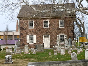
Old St. Gabriel's Episcopal Church, founded 1720. This building built in 1801.

Douglassville is a community in Amity, Union Townships, and Douglass Townships Berks County, Pennsylvania, United States. Douglassville is situated along U.S. Route 422. Developments include the Amity Gardens subdivision, the West Ridge subdivision, the Briarwood subdivision, and the High Meadow subdivision. Douglassville also includes Cider Mill and The Woods Edge subdivision along Pennsylvania Route 562.
Contents
History
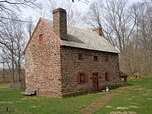
Monce Jones House, built 1716
Swedish pioneers were the first European settlers in present Berks County on land granted by William Penn. Swedish Lutheran Minister Andreas Rudman secured an order from William Penn on October 21, 1701 setting aside 10,000 acres (40 km2) up the Schuylkill, near Manatawny Creek, for members of his congregation. The boundaries of Amity Township are almost identical to the boundaries of the original area known as Swedes’ tract. Morlatton Village, an early settlement which became part of what is now Douglassville, was Berks County's first settlement site along the Schuylkill River. The settlement later became the location of Old St. Gabriel's Episcopal Church or Old Swedes, founded in 1720 as the oldest church in Berks County. The site also included the Mounce Jones House, built by Swedish settlers in 1716. The house is the oldest documented dwelling in Berks County.[1][2]
Parks
Lake Drive Park and Recreation Area
It is on Lake Drive in the Amity Gardens Subdivision. Facilities include Basketball and Tennis Courts, a skateboard park, a pavilion, and a picnic area.
Hill Road Park
Hill Road Park is located on Hill Road in the West Ridge subdivision.
Monocacy Hill Preserve
Monocacy Hill Preserve is an undeveloped park used for hiking and environmental education on Monocacy Hill, it is right outside of Douglassville.
Notable Residents
Daniel Boone - (Oct 1734 - Sept 1820) An American pioneer, explorer, and frontiersman whose frontier exploits made him one of the first folk heroes of the United States.
References
External links
- Schuylkill River National & State Heritage Area
- Morlatton Village
- St. Gabriel’s Episcopalian Church
- Thun Trail to Morlatton Village in Douglassville
- Morlatton Village Gallery
- Mouns Jones House
Municipalities and communities of Berks County, Pennsylvania City Boroughs Adamstown‡ | Bally | Bechtelsville | Bernville | Birdsboro | Boyertown | Centerport | Fleetwood | Hamburg | Kenhorst | Kutztown | Laureldale | Leesport | Lenhartsville | Lyons | Mohnton | Mount Penn | New Morgan | Robesonia | St. Lawrence | Shillington | Shoemakersville | Sinking Spring | Strausstown | Topton | Wernersville | West Reading | Womelsdorf | Wyomissing
Townships Albany | Alsace | Amity | Bern | Bethel | Brecknock | Caernarvon | Centre | Colebrookdale | Cumru | District | Douglass | Earl | Exeter | Greenwich | Heidelberg | Hereford | Jefferson | Longswamp | Lower Alsace | Lower Heidelberg | Maidencreek | Marion | Maxatawny | Muhlenberg | North Heidelberg | Oley | Ontelaunee | Penn | Perry | Pike | Richmond | Robeson | Rockland | Ruscombmanor | South Heidelberg | Spring | Tilden | Tulpehocken | Union | Upper Bern | Upper Tulpehocken | Washington | Windsor
CDPs Unincorporated
communitiesAlbany | Alleghenyville | Alsace Manor | Amityville | Barto | Basket | Baumstown | Beckersville | Berne | Bethel | Blandon | Bowers | Boyers Junction | Breezy Corner | Brownsville | Chapel‡ | Clayton | Dale | Dauberville | Douglassville | Dreibelbis | Dryville | Eckville | Edenburg | Eshbach | Evansville | Five Points | Fredericksville | Fritztown | Frystown | Geigertown | Gibraltar | Gouglersville | Greenawald | Grill | Grimville | Hancock | Harlem | Henningsville | Hereford | Hinterleiter | Host | Huffs Church | Hyde Park | Jacksonwald | Jalappa | Joanna | Joanna Heights | Kempton | Kempville | Kirbyville | Klinesville | Knauers | Krumsville | Kulptown | Landis Store | Leinbachs | Limekiln | Lincoln Park | Lobachsville | Longswamp | Manatawny | Maple Grove | Maxatawny | Mertztown | Mohrsville | Molltown | Montello | Monterey | Morgantown | Morysville | Moselem | Moselem Springs | Mount Aetna | New Hensingersville‡ | New Jerusalem | North Heidelberg | Pine Waters | Pleasant Valley | Pleasantville | Plowville | Pricetown | Quaker City | Rehrersburg | Rittenhouse Gap | Sally Ann | Scarlets Mill | Seisholtzville | Shartlesville | South Temple | State Hill | Stony Run | Stouchsburg | Temple | Trexler | Unionville | Vinemont | Virginville | Walnuttown | Weavertown | West Hamburg | West Lawn | Windsor Castle | Wintersville | Woodchoppertown | Wyomissing Hills | Yellow House
Footnotes ‡This populated place also has portions in an adjacent county or counties
- Douglassville, Pennsylvania is at coordinates 40°15′26″N 75°43′35″W / 40.2572°N 75.7263°WCoordinates: 40°15′26″N 75°43′35″W / 40.2572°N 75.7263°W
Categories:- Populated places in Berks County, Pennsylvania
- Pennsylvania geography stubs
Wikimedia Foundation. 2010.


