- Cochabamba Department
-
For other uses, see Cochabamba (disambiguation).
Department of Cochabamba
Quchapampa suyu
Flag
Coat of armsNickname(s): "City of Eternal Spring" Location within Bolivia
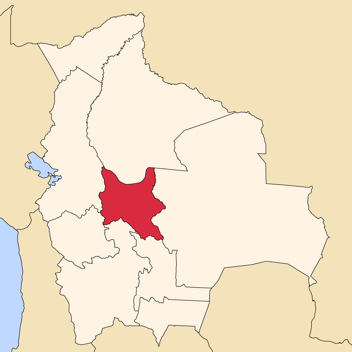
Country  Bolivia
Established as department by law 1826 Autonomous department by referendum 2009 Capital Cochabamba Government – Governor Edmundo Novillo Aguilar Area – City 55,631 km2 (21,479.2 sq mi) Elevation 2,574 m (8,445 ft) Population (2007) – City 1,750,000 – Urban 608,276 Time zone BOT (UTC-4) HDI (2004) - ISO 3166-2 BO-C Postal abbrv. Website http://www.cochabamba.bo/ Cochabamba (from Quechua: qucha or qhucha, meaning "lake", pampa meaning "plain" [1]) is one of the nine component departments of Bolivia. It is known to be the "granary" of the country because of its variety of agricultural products due to Cochabamba's geographical position. It has an area of 55,631 km². Its population, in the 2007 census, was 1,750,000. Its capital is the city of Cochabamba. Cochabamba is known as the "City of Eternal Spring" and "The Garden City" due to its spring-like temperatures year round.
Contents
History
The Cochabamba valley was inhabited for over a thousand years due to its fertile productive soils and climate. Archaeological evidence suggests that the initial valley inhabitants were of various ethnic indigenous groups. Inca, Tupuraya, Mojocoya, Omereque, and Tiwanaku inhabited the valley at various times before the Spanish arrived.
The first Spanish inhabitant of the Valley was Garci Ruiz de Orellana in 1542. He purchased the majority of the land from local tribal chiefs Achata and Consavana through a title registered in 1552 at the Imperial City of Potosí. The price paid was 130 pesos. His residence, known as the House of Mayorazgo, still stands in the Cala Cala neighbourhood of the city.
The city, called Villa de Oropesa was founded on 2 August 1571 by order of Viceroy Francisco de Toledo, Count of Oropesa. It was to be an agricultural production centre to provide food for the mining towns of the relatively nearby Altiplano region, particularly the city of Potosí which became one of the largest and richest cities in the world during the 17th century - funding the vast wealth that ultimately made Spain a world power at the time. With the silver mining industry in Potosi at its height, Cochabamba thrived during its first centuries of existence. The city entered a period of decline during the 18th century as mining began to wane.
In 1786, King Charles III of Spain renamed the city to the 'loyal and valiant' Villa of Cochabamba. This was done to commend the city's pivotal role in suppressing the indigenous rebellions of 1781 in Oruro by sending armed forces to Oruro to quell the uprisings. Since the late 19th century it has again been generally successful as an agricultural centre for Bolivia.
The 1793 census shows that the city had a population of 22,305 persons. There were 12,980 mestizos, 6,368 Spaniards, 1,182 indigenous natives, 1,600 mulattos and 175 African slaves.
In 2000, Cochabamba was wracked with large-scale protests over the privatisation of the city's water supply. See Cochabamba protests of 2000.
In January 2007 city dwellers clashed with mostly rural protestors, leaving four dead and over 130 injured. The democratically-elected Prefect of Cochabamba, Manfred Reyes Villa, a former military aide to the Luis García Meza dictatorship of the 1980s, had allied himself with the leaders of Bolivia's Eastern Departments in a dispute with President Evo Morales over regional autonomy and other political issues. The protestors blockaded the highways, bridges, and main roads, having days earlier set fire to the departmental seat of government, trying to force the resignation of Reyes Villa. Citizens attacked the protestors, breaking the blockade and routing them, while the police did little to stop the violence. Further attempts by the protestors to reinstate the blockade and threaten the government were unsuccessful, but the underlying tensions have not been resolved.
In July 2007, a monument erected by veterans of January's protest movement in honour of those killed and injured by government supporters was destroyed in the middle of the night, reigniting racial conflicts in the city.
In August 2008, a nationwide referendum was held, and while the president Evo Morales had 67% support in Bolivia, the prefect of Cochabamba, Manfred Reyes Villa, was not confirmed by the voters of the department.
Geography
Cochabamba Department is bordered by Chuquisaca and Potosi Department to the south, Oruro and La Paz Department to the west, Beni Department to the north, and Santa Cruz Department to the east. The borders are formed mainly by rivers, like Ichilo to the east, Rio Grande to the south and Cotacajes to the west.[2]
Government
The chief executive office of Bolivia departments (since May 2010) is the governor; until then, the office was called the prefect, and until 2006 the prefect was appointed by the President of Bolivia. The current governor, Edmundo Novillo Aguilar of the Movement for Socialism – Political Instrument for the Sovereignty of the Peoples was elected on 4 April 2010 and took office 30 May.
Under the 2009 Constitution, Bolivian departments have an elected legislature, the Departmental Legislative Assembly. The Cochabamba Assembly has 34 members including two indigenous representatives.
The most recent election results are as follows.
Cochabamba departmental election, 2010 Gubernatorial Candidate Party Votes for Governor Percentage Assembly Members by Territory Votes for Assembly by Population Percentage Assembly Members by Population Total Assembly Members Edmundo Novillo Aguilar Movement for Socialism 415.245 61,9% 16 360.785 60,7% 11 27 Marvell José María Leyes Justiniano National Unity Front-Popular Consensus (All for Cochabamba) 174.175 26,0% 0 147.442 24,8% 4 4 José Ronald Del Barco Alcocer Without Fear Movement 52.516 7,8% 0 63.614 10,7% 1 1 María Casta Jaimes Arriaran Nationalist Revolutionary Movement 29.250 4,4 0 22.800 3,8% 0 0 Indigenous Representatives Elected through usos y costumbres by the Yuqui and Yuracaré peoples 2 Valid votes 671.186 81,9% 594.641 72,7% Blank votes 111.510 13,6 183.077 22,4% Null votes 36.905 4,5% 40.713 5,0% Total votes 819.601 87,2% of registered voters 16 818.431 87,1% of registered voters 16 34 Source: Corte Nacional Electoral, Acto de Computo Nacional Provinces
The Department of Cochabamba is divided into 16 provinces (provincias) which are further subdivided into 47 municipalities [3] (municipios) and - on the fourth level - into 144 cantons.
The provinces with their capitals are:
Province Capital km² Population 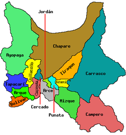
Arani Arani 506 24.372 Arque Arque 1.077 26.283 Ayopaya Ayopaya 9.620 63.997 Bolívar Bolívar 413 9.470 Capinota Capinota 1.495 26.053 Carrasco Totora 15.045 140.481 Cercado Cochabamba 391 564.882 Chapare Sacaba 12.445 227.404 Esteban Arce Tarata 1.245 32.986 Germán Jordán Cliza 305 33.876 Mizque Mizque 2.730 40.702 Narciso Campero Aiquile 5.550 40.532 Punata Punata 850 47.653 Quillacollo Quillacollo 720 303.903 Tapacarí Tapacarí 1.500 29.712 Tiraque Tiraque 1.739 36.738 Languages
The languages spoken in the Cochabamba Department are mainly Spanish and Quechua. The following table shows the number of those belonging to the recognised group of speakers.[4]
Language Department Bolivia Quechua 872,010 2,281,198 Aymara 84,921 1,525,321 Guaraní 1,379 62,575 Another native 3,351 49,432 Spanish 1,101,822 6,821,626 Foreign 40,579 250,754 Only native 269,588 960,491 Native and Spanish 648,195 2,739,407 Spanish and foreign 454,273 4,115,751 Population and Demographics
Description Department Bolivia Inhabitants 1.455.711 8.274.325 Rural 41 % - Urban 59 % - Total fertility rate 4.00 4.40 Infant mortality 72.00 66.00 Net migration rate 2.40 - Places of interest
- Carrasco National Park
- Tunari National Park
- Isiboro Sécure National Park and Indigenous Territory
- Inkallajta
- Inkachaka
- Inkaraqay
- Quillacollo
- Villa Tunari
- Laguna La Angostura
- Pairumani: The Pairumani estate about 20 km from the city of Cochabamba comprises Villa Albina, a landed estate which was property of the Bolivian industrialist Simón I. Patiño, built between 1925 and 1932, a model farm and seed centre and a Centre for Phytoecogenetic Research.[5] The palace of Pairumani was declared Bolivian National Monument in 1967.
References
- ^ Diccionario Bilingüe Iskay simipi yuyayk'ancha pdf
- ^ Andes Travel Map
- ^ www.bolivia.com (English)
- ^ obd.descentralizacion.gov.bo (Spanish)
- ^ Pairumani
External links
- Cochabamba Travel Guide
- Weather in Cochabamba
- Bolivian Music and Web Varieties
- Pictures: Coca cultivation in the Cochabamba Tropic
- [1]
Departments of Bolivia Beni · Chuquisaca · Cochabamba · La Paz · Oruro · Pando · Potosí · Santa Cruz · Tarija

 Cochabamba Department
  Capital: Cochabamba
Provinces Arani • Arque • Ayopaya • Bolívar • Capinota • Carrasco • Cercado • Chapare • Esteban Arce •Germán Jordán • Mizque • Narciso Campero • Punata •Quillacollo • Tapacarí • Tiraque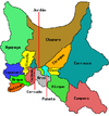
Municipalities (and seats) Aiquile (Aiquile) • Alalay (Alalay) • Anzaldo (Anzaldo) • Arani (Arani) • Arbieto (Arbieto) • Arque (Arque) • Ayopaya (Ayopaya) • Bolívar (Bolívar) • Capinota (Capinota) • Chimoré (Chimoré) • Cliza (Cliza) • Cocapata (Cocapata) • Cochabamba (Cochabamba) • Colcapirhua (Colcapirhua) • Colomi (Colomi) • Cuchumuela (Cuchumuela) • Entre Ríos Municipality (Entre Ríos) Mizque (Mizque) • Morochata (Morochata) • Omereque (Omereque) • Pasorapa (Pasorapa) • Pocona (Pocona) • Pojo (Pojo) • Puerto Villarroel (Puerto Villarroel) • Punata (Punata) • Quillacollo (Quillacollo) • Sacaba (Sacaba) • Sacabamba (Sacabamba) • San Benito (San Benito) • Santiváñez (Santiváñez) • Shinahota (Shinahota) • Sicaya (Sicaya) • Sipe Sipe (Sipe Sipe) • Tacachi (Tacachi) • Tacopaya (Tacopaya) • Tapacarí (Tapacarí) • Tarata (Tarata) • Tiquipaya (Tiquipaya) • Tiraque (Tiraque) • Toco (Toco) • Tolata (Tolata) • Totora (Totora) • Vacas (Vacas) • Vila Vila (Vila Vila) • Villa Rivero (Villa Rivero) • Villa Tunari (Villa Tunari) • Vinto (Vinto)Categories:


Wikimedia Foundation. 2010.