- Omereque
-
Omereque — Town — Location within Bolivia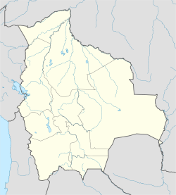
 Omereque
Coordinates: 18°06′24″S 64°54′26″W / 18.10667°S 64.90722°WCoordinates: 18°06′24″S 64°54′26″W / 18.10667°S 64.90722°W Country  Bolivia
Department Cochabamba Department Province Narciso Campero Province Municipality Omereque Municipality Foundation Government – Mayor – President Elevation 5,210 ft (1,588 m) Population (2001) – Total 885 Time zone -4 (UTC-4) Omereque is a location in the Cochabamba Department in central Bolivia. It is the seat of the Omereque Municipality, the third municipal section of the Narciso Campero Province.
The archeological site Fuerte de Samaipata is about 115 km away from the town. It is about 187 km away from the city of Potosí.[1] The nearest international airport (LIM) of Lima in Peru, Jorge Chavez International Airport, is situated about 1,475 km from the town.
References
- www.ine.gov.bo
External links
 Cochabamba Department
  Capital: Cochabamba
Provinces Arani • Arque • Ayopaya • Bolívar • Capinota • Carrasco • Cercado • Chapare • Esteban Arce •Germán Jordán • Mizque • Narciso Campero • Punata •Quillacollo • Tapacarí • Tiraque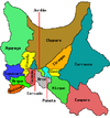
Municipalities (and seats) Aiquile (Aiquile) • Alalay (Alalay) • Anzaldo (Anzaldo) • Arani (Arani) • Arbieto (Arbieto) • Arque (Arque) • Ayopaya (Ayopaya) • Bolívar (Bolívar) • Capinota (Capinota) • Chimoré (Chimoré) • Cliza (Cliza) • Cocapata (Cocapata) • Cochabamba (Cochabamba) • Colcapirhua (Colcapirhua) • Colomi (Colomi) • Cuchumuela (Cuchumuela) • Entre Ríos Municipality (Entre Ríos) Mizque (Mizque) • Morochata (Morochata) • Omereque (Omereque) • Pasorapa (Pasorapa) • Pocona (Pocona) • Pojo (Pojo) • Puerto Villarroel (Puerto Villarroel) • Punata (Punata) • Quillacollo (Quillacollo) • Sacaba (Sacaba) • Sacabamba (Sacabamba) • San Benito (San Benito) • Santiváñez (Santiváñez) • Shinahota (Shinahota) • Sicaya (Sicaya) • Sipe Sipe (Sipe Sipe) • Tacachi (Tacachi) • Tacopaya (Tacopaya) • Tapacarí (Tapacarí) • Tarata (Tarata) • Tiquipaya (Tiquipaya) • Tiraque (Tiraque) • Toco (Toco) • Tolata (Tolata) • Totora (Totora) • Vacas (Vacas) • Vila Vila (Vila Vila) • Villa Rivero (Villa Rivero) • Villa Tunari (Villa Tunari) • Vinto (Vinto)Categories:- Populated places in the Cochabamba Department
- Cochabamba Department, Bolivia geography stubs


Wikimedia Foundation. 2010.