- Chuquisaca Department
-
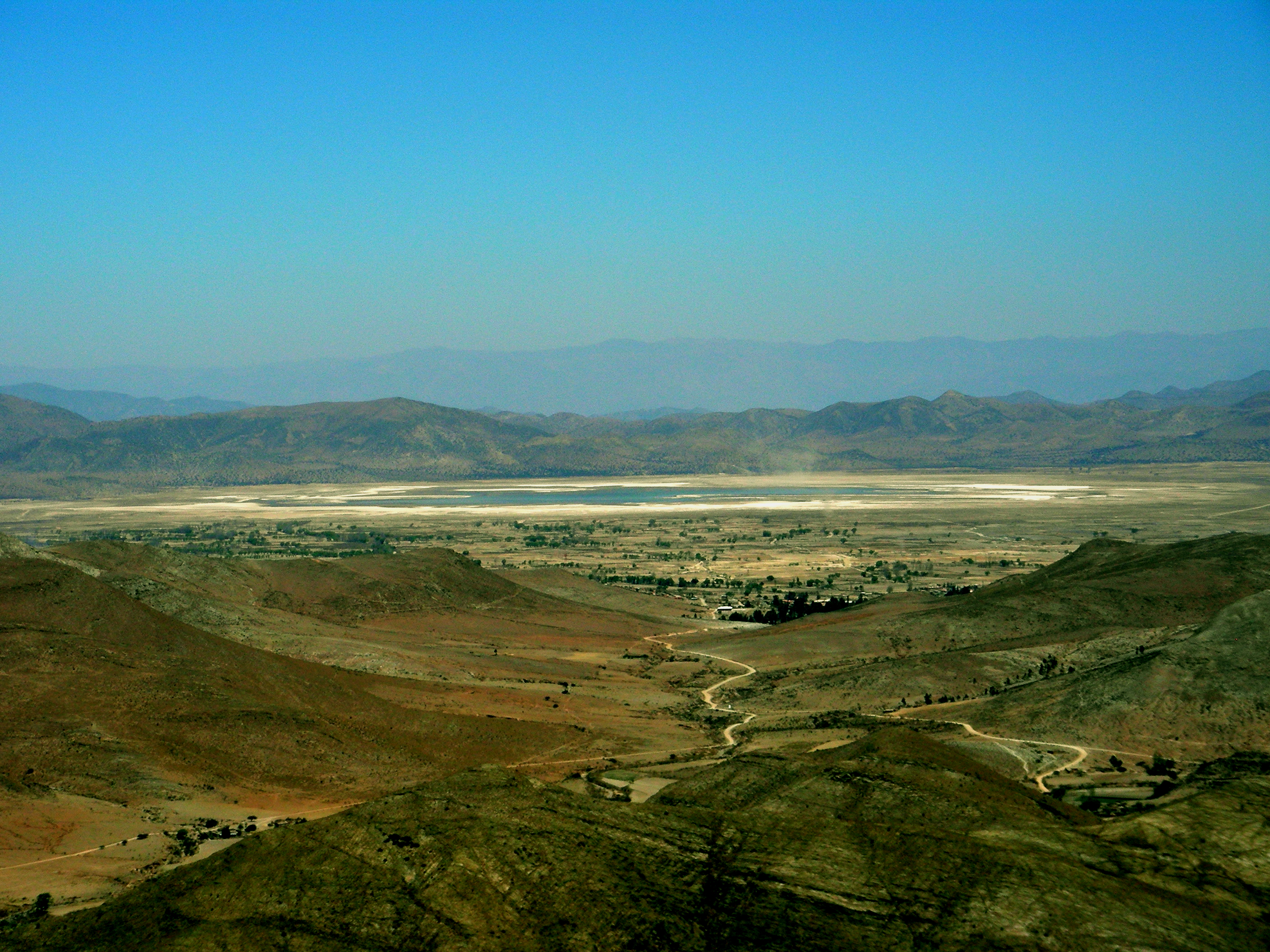
Department of Chuquisaca Laguna de Culpina

FlagLocation within Bolivia
Country  Bolivia
Capital Government – Governor Esteban Urquizu Cuéllar Area – Total 51,524 km2 (19,893.5 sq mi) Population (2005) – Total 572,165 Time zone BOT (UTC-4) HDI (2004) - ISO 3166-2 BO-H Postal abbrv. Website http://www.chuquisaca.gob.bo/ Chuquisaca is a department of Bolivia located in the center south. It borders on the departments of Cochabamba, Tarija, Potosí, and Santa Cruz. The departmental capital is Sucre, which is also the constitutional capital of Bolivia.
Contents
Geography
The department is traversed by the main cordillera of the Andes mountain range and lesser cordilleras. Parts of it lie within the basin of the Amazon River, and other parts within the basin of the Río de La Plata. The surface area of the department is 51,524 square kilometers[1]. The topography of central Chuquisaca consists of a series of ridges rising up to 1500 m that run north and south with flat valleys between the ridges. To the east of these ridges abruptly rise the Andes Mountains to 3000 m forming a prepuna landmass that is cut into by large river valleys that drain into the Amazon or Rio de la Plata river basins. To the west of the central ridges lies a stretch of territory containing low altitude flat Chaco topography[2]. 90% of the land in the department of Chuquisaca has inclination of 70% or more[3].
Ecological and Vegetation Zones
Ecological and vegetation zones in the department of Chuquisaca vary widely according to a diversity of abiotic factors including soil formation and textures, rainfall patterns, and mineral and salinity content of water. Altitude plays an important role in the dispersion of vegetation species and wider ecosystems as they respond to microclimates. As the Andes Mountains became uplifted, plants adapted to dryer and higher microclimates resulting in a high level of speciation especially in the dry forest river valleys of the Bolivian-Tucuman formation[4]. Colder and dryer air from more austral parts of South America have resulted in migration of plant communities with a floristic connection to those in Argentina, Paraguay and Southern Brazil as opposed to more tropical plant communities that result from warm and moist northern climates[5]. Navarro and Ferreira have developed a database of plant species in Bolivia[6] and identified 39 separate vegetation zones in Bolivia within twelve general physiographic-biogeographical units of which four fall in the boundaries of Chuquisaca Department including: Cordillera Oriental Central y Meridional, Prepuna or High Interandean Valleys, Bolivian-Tucuman Formation, and Chaco. Using Navarro and Ferreira’s categories and descriptions based on vegetation zones, the geographical and ecological characteristics of the Chuquisaca Department can be described as follows.
Cordillera Oriental Central y Meridional: From an altitude of 3200m in Chuquisaca to nearly 6000 meters in Potosi, this zone is characterized by the puna, altoandean, and subnival and nival ecological zones with a pluviestacional subhumed bioclimate[7].
Prepuna or High Interandean Valleys: From 2300m to 3200m, this zone is characterized by a mesotropical dry xeric bioclimatic zone. Seasonally torrential waters and salinity levels affect regional vegetation patterns in this zone[8].
Bolivian-Tucuman Formation: With a wide altitude range between 600m to 3900m this zone contains pluviestacional subhumid and locally humid bioclimatic zones. The high altitude Rio Grande and Pilcomayo river valleys transect this unit and are characterized by dry xeric vegetation zones with endemic and varied speciation especially in the Rio Grande river valley and vegetation influence from the Chaco in the Pilcomayo river valley[9][10]. Wet forest ecosystems like those found in more northern Yungas valleys are found on high ridges where clouds form[11].
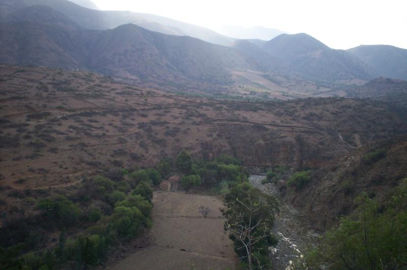
 Xeric River Valley near Presto, Bolivia
Chaco: from 400-900 m this unit is characterized by a xeric bioclimate. Sandy soils in this unit were formed from alluvial processes from the Parapeti and Grande rivers. Soil drainage affects vegetation dispersion within this unit[12].
Human Ecological Impacts
With a human population of 631,000 people[13] humans are a part of the ecology of Chuquisaca. The grazing of cattle and introduction of invasive feral citrus trees has affected the native plant populations in the department[14]. Native forests and ecosystems have contracted as land has been converted to pasture and erosion is widespread as a result of human agricultural activities on steep slopes[15].[16]
Government
The chief executive office of Bolivia departments (since May 2010) is the governor; until then, the office was called the prefect, and until 2006 the prefect was appointed by the President of Bolivia. The current governor, Esteban Urquizu Cuéllar of the Movement for Socialism – Political Instrument for the Sovereignty of the Peoples was elected on 4 April 2010.
Date Began Date Ended Prefect/Governor Party Notes 23 Jan 2006 30 Aug 2007 David Sanchez Heredia MAS-IPSP Elected in Bolivian general election, December 2005 30 Aug 2007 20 Sep 2007 Adrián Valeriano (acting) MAS 20 Sep 2007 18 Dec 2007 David Sanchez Heredia MAS 18 Dec 2007 11 Jul 2008 Ariel Iriarte (acting) 11 Jul 2008 30 May 2010 Sabina Cuéllar Leaños ACI Elected in special election on 29 June; final prefect 30 May 2010 Esteban Urquizu Cuéllar MAS-IPSP Elected in regional election on 4 April; first governor Source: worldstatesmen.org Provinces
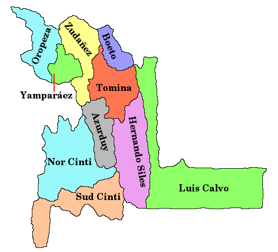
The department is divided into 10 provinces which are further subdivided into municipalities and cantons.
Name Population Area km² Capital 
Oropeza 275.765 3.943 Sucre Azurduy 27.973 4.185 Azurduy Jaime Zudáñez 34.640 3.738 Presto Tomina 38.359 3.947 Padilla Hernando Siles 37.035 5.473 Monteagudo Yamparáez 28.797 1.472 Tarabuco Nor Cinti 71.084 7.983 Camargo Sud Cinti 24.010 5.484 Villa Abecia Belisario Boeto 12.237 2.000 Villa Serrano Luis Calvo 22.275 13.299 Villa Vaca Guzmán (Muyupampa) History
The native inhabitants were the Charcas, who were dispersed along riverbanks and lowlands. Their leaders, jampiris, sorcerers, and priests resided in the capital, Choque-Chaca, which according to 17th century chronicles had a population of several thousand.[citation needed]
The capital city of Sucre
Sucre (elev. 2750 m) is called the city of the four names, each name corresponding to a different period of its history. It was founded by the Spaniard Pedro de Anzures in 1538. It thrived due to its regional proximity to the famous silver mines of Potosi, and as Charcas served as capital of the Real Audiencia de Charcas, encompassing all of current Bolivia's territory and more. Reverting to its native name of Chuquisaca, it was the Upper Peru's chief administrative center and largest city. It was there that the first public call for independence from Spain took place, on May 25, 1809, and where the Act of Independence from Spanish rule was signed on August 6, 1825. It was immediately designated the capital of independent Bolivia, under the auspices of Simon Bolivar and Antonio Jose de Sucre. Years later, the city of Chuquisaca was renamed Sucre in honor of the Venezuelan-born hero of South America's independence, who had served as the first effective administrator of the country (and second President).
When the center of political and economic power shifted north, to the tin-producing regions of Oruro and La Paz, Sucre's importance waned, leading to the displacement of the legislative and executive powers to La Paz. However, in honor of Sucre's historical preponderance, the judicial branch (Supreme Court) continues to operate there, and the city's official status as capital of the country was never revoked.
Languages
The languages spoken in the department are mainly Spanish and Quechua. The following table shows the number of those belonging to the recognized group of speakers.[17]
Language Department Bolivia Quechua 298,050 2,281,198 Aymara 4,308 1,525,321 Guaraní 8,330 62,575 Another native 145 49,432 Spanish 376,071 6,821,626 Foreign 8,840 250,754 Only native 122,401 960,491 Native and Spanish 185,598 2,739,407 Spanish and foreign 190,599 4,115,751 Places of interest
- El Palmar Integrated Management Natural Area
See also
References
- ^ "Atlas de Potencialidades Productivas del Estado Plurinacional de Bolivia". Atlas de Potencialidades Productivas del Estado Plurinacional de Bolivia. http://sitap.produccion.gob.bo/Atlas_Productivo_2009_web/CHUQUISACA.pdf. Retrieved 14 June 2011.
- ^ Schulenberg, T; K. Awbrey (1997). "A rapid assessment of the humid forests of South Central Chuquisaca, Bolivia". RAP Working Papers 8, Conservation International.
- ^ "Atlas de Potencialidades Productivas del Estado Plurinacional de Bolivia". Atlas de Potencialidades Productivas del Estado Plurinacional de Bolivia. http://sitap.produccion.gob.bo/Atlas_Productivo_2009_web/CHUQUISACA.pdf. Retrieved 14 June 2011.
- ^ Lopez, R.P. (2003). "Phytogeographical relations of the Andean dry valleys of Bolivia". Journal of Biogeography. 1659-1668 30.
- ^ Lopez, R.P. (2003). "Phytogeographical relations of the Andean dry valleys of Bolivia". Journal of Biogeography. 1659-1668 30.
- ^ Navarro, G; W. Ferreira (2004). "Zonas de vegetacion potencial de Bolivia: una base para el analisis de vacios de conservacion". Revista Boliviana de Ecologia y Conservacion Ambiental 15.
- ^ Navarro, G; W. Ferreira (2004). "Zonas de vegetacion potencial de Bolivia: una base para el analisis de vacios de conservacion". Revista Boliviana de Ecologia y Conservacion Ambiental 15.
- ^ Navarro, G; W. Ferreira (2004). "Zonas de vegetacion potencial de Bolivia: una base para el analisis de vacios de conservacion". Revista Boliviana de Ecologia y Conservacion Ambiental 15.
- ^ Navarro, G; W. Ferreira (2004). "Zonas de vegetacion potencial de Bolivia: una base para el analisis de vacios de conservacion". Revista Boliviana de Ecologia y Conservacion Ambiental 15.
- ^ Lopez, R.P. (2003). "Phytogeographical relations of the Andean dry valleys of Bolivia". Journal of Biogeography. 1659-1668 30.
- ^ Schulenberg, T; K. Awbrey (1997). "A rapid assessment of the humid forests of South Central Chuquisaca, Bolivia". RAP Working Papers 8, Conservation International.
- ^ Navarro, G; W. Ferreira (2004). "Zonas de vegetacion potencial de Bolivia: una base para el analisis de vacios de conservacion". Revista Boliviana de Ecologia y Conservacion Ambiental 15.
- ^ "Censo de Poblacion y Vivienda 2001". Instituto Nacional de Estadistica (INE). http://www.ine.gob.bo/comunitaria/comunitariaVer.aspx?Depto=01&Prov=00&Seccion=00.
- ^ Schulenberg, T; K. Awbrey (1997). "A rapid assessment of the humid forests of South Central Chuquisaca, Bolivia". RAP Working Papers 8, Conservation International.
- ^ "Atlas de Potencialidades Productivas del Estado Plurinacional de Bolivia". Atlas de Potencialidades Productivas del Estado Plurinacional de Bolivia. http://sitap.produccion.gob.bo/Atlas_Productivo_2009_web/CHUQUISACA.pdf. Retrieved 14 June 2011.
- ^ Zak, M.; J. Hodgson (2004). "Do subtropical seasonal forests in the Gran Chaco, Argentina, have a future?". Biological Conservation. 589-598 120.
- ^ obd.descentralizacion.gov.bo (Spanish)
External links
- Chuquisaca Travel Guide
- Weather in Chuquisaca
- Bolivian Music and Web Varieties
- Lots of photos of indigenous fiestas, including the famous Pujllay of Tarabuco and the Tarabuco market
 Chuquisaca DepartmentCapital: Sucre
Provinces Azurduy • Belisario Boeto • Hernando Siles • Jaime Zudáñez • Luis Calvo • Nor Cinti • Oropeza • Sud Cinti • Tomina • YamparáezMunicipalities and seats Camargo (Camargo) • Camataqui (Camataqui) • Culpina (Culpina) • El Villar (El Villar) • Huacareta (Huacareta) • Huacaya (Huacaya) • Icla (Icla) • Incahuasi (Incahuasi) • Las Carreras (Las Carreras) • Macharetí (Macharetí) • Mojocoya (Mojocoya) • Monteagudo (Monteagudo) • Muyupampa (Villa Vaca Guzmán) • Padilla (Padilla) • Poroma (Poroma) • Presto (Presto) • San Lucas (San Lucas) • Sopachuy (Sopachuy) • Sucre (Sucre) • Tarabuco (Tarabuco) • Tarvita (Tarvita) • Tomina (Tomina) • Villa Alcalá (Villa Alcalá) • Villa Charcas (Villa Charcas) • Villa Serrano (Villa Serrano) • Villa Zudáñez (Zudáñez) • Yotala (Yotala) • Villa Azurduy (Azurduy) • Yamparáez (Yamparáez)Departments of Bolivia Beni · Chuquisaca · Cochabamba · La Paz · Oruro · Pando · Potosí · Santa Cruz · Tarija
 Categories:

Wikimedia Foundation. 2010.