- Oropeza Province
-
Oropeza Province — Province — Sucre, the constitutional capital of Bolivia and the capital of the Oropeza Province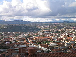 Location of Oropeza Province within Bolivia
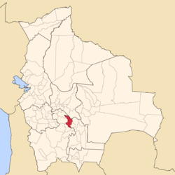
Coordinates: 18°50′S 65°15′W / 18.833°S 65.25°W Country  Bolivia
Department Chuquisaca Department Capital Sucre Area – Total 1,522.4 sq mi (3,943 km2) Elevation 6,562 ft (2,000 m) Population (2001) – Total 241,376 – Density 158.5/sq mi (61.2/km2) – Ethnicities Quechuas Time zone GMT -4 Oropeza is a province in the Chuquisaca Department, Bolivia. Its seat is Sucre which is also the constitutional capital of Bolivia and the capital of the Chuquisaca Department.
Contents
Subdivision
The province is divided into three municipalities which are further subdivided into cantons.
Section Municipality Inhabitants (2001) [1] Seat Inhabitants (2001) Capital Municipality Sucre Municipality 214,913 Sucre 193,876 1st Yotala Municipality 9,497 Yotala 1,538 2nd Poroma Municipality 16,966 Poroma 486 The people
The people are predominantly indigenous citizens of Quechuan descent.
Ethnic group Sucre Municipality (%) Yotala Municipality (%) Poroma Municipality (%) Quechua 57.3 90.4 94.7 Aymara 2.3 0.8 0.9 Guaraní, Chiquitos, Moxos 1.4 0.2 0.1 Not indigenous 38.6 8.3 4.2 Other indigenous groups 0.4 0.3 0.1 Ref.: obd.descentralizacion.gov.bo
Languages
The languages spoken in the province are mainly Spanish and Quechua.
Language Sucre Municipality Yotala Municipality Poroma Municipality Quechua 116,053 8,197 15,554 Aymara 3,322 68 165 Guaraní 344 8 4 Another native 67 0 4 Spanish 183,231 5,587 4,620 Foreign 8,156 41 8 Only native 19,901 3,319 11,057 Native and Spanish 97,831 4,916 4,513 Only Spanish 85,497 673 107 Ref.: obd.descentralizacion.gov.bo
Places of interest
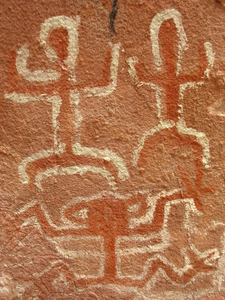
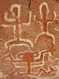 Cave paintings at Inkamachay
The archaeological sites of Inkamachay (also spelled Incamachay or Inca machay) and Pumamachay are situated within the province. Inkamachay was declared a National Monument in 1958. [2]
References
- ^ www.ine.gov.bo (Spanish)
- ^ Archaeological parks in Bolivia
 Chuquisaca DepartmentCapital: Sucre
Provinces Azurduy • Belisario Boeto • Hernando Siles • Jaime Zudáñez • Luis Calvo • Nor Cinti • Oropeza • Sud Cinti • Tomina • Yamparáez
Municipalities and seats Camargo (Camargo) • Camataqui (Camataqui) • Culpina (Culpina) • El Villar (El Villar) • Huacareta (Huacareta) • Huacaya (Huacaya) • Icla (Icla) • Incahuasi (Incahuasi) • Las Carreras (Las Carreras) • Macharetí (Macharetí) • Mojocoya (Mojocoya) • Monteagudo (Monteagudo) • Muyupampa (Villa Vaca Guzmán) • Padilla (Padilla) • Poroma (Poroma) • Presto (Presto) • San Lucas (San Lucas) • Sopachuy (Sopachuy) • Sucre (Sucre) • Tarabuco (Tarabuco) • Tarvita (Tarvita) • Tomina (Tomina) • Villa Alcalá (Villa Alcalá) • Villa Charcas (Villa Charcas) • Villa Serrano (Villa Serrano) • Villa Zudáñez (Zudáñez) • Yotala (Yotala) • Villa Azurduy (Azurduy) • Yamparáez (Yamparáez)Categories:- Bolivia geography stubs
- Provinces of Bolivia
- Chuquisaca Department


Wikimedia Foundation. 2010.