Oakland Harbor Light

Oakland Harbor Light

Coordinates: 37°46′52.69″N 122°14′37.65″W / 37.7813028°N 122.2437917°W / 37.7813028; -122.2437917

Oakland Harbor Light
USCGoaklandharbor.JPG
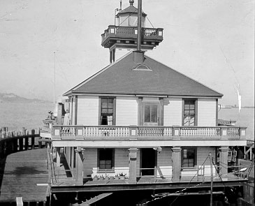
U.S. Coast Guard Archive
Location Embarcadero Cove, California
Year first constructed 1890
Year first lit 1890
Deactivated 1966
Foundation Concrete Pilings
Construction Wood
Tower shape Square
Height ft
Original lens Fifth order Fresnel lens (removed)
Characteristic Fixed White
ARLHS number USA-560

Oakland Harbor Light is a former lighthouse, now a restaurant in Embarcadero Cove, California.

History

The original tower was built in 1890 at the entrance of Oakland Harbor. The wooden pilings on which the structure sat had deteriorated by 1902, and a larger replacement lighthouse was constructed on concrete pilings nearby, which began operation in 1903. The original structure was then sold and removed. In 1966, the lighthouse was replaced by an automated beacon and deactivated. It was eventually sold to a private party and relocated to Embarcadero Cove in Oakland, where it opened in 1984 as Quinn’s Lighthouse Restaurant. The lantern room was removed after deactivation in 1966, and was transferred to Mark Abbott Memorial Lighthouse in Santa Cruz, California, where it continued to deteriorate and was replaced in 1996.

External links


Wikimedia Foundation. 2010.

Игры ⚽ Поможем написать курсовую

Look at other dictionaries:

  • Los Angeles Harbor Light — Infobox Lighthouse caption = location = Los Angeles Harbor, California coordinates = coord|33|42|30|N|118|15|05|W|region:US type:landmark yearlit = 1762 automated = 1971 yeardeactivated = foundation = Rock breakwater with Concrete Slabs… …   Wikipedia

  • Oakland, California — Oakland redirects here. For other uses, see Oakland (disambiguation). Oakland   City   City of Oakland …   Wikipedia

  • Mare Island Light — Location San Pablo Bay, California Year first constructed 1873 Deactivated 1917 Construction Wood and Iron Tower shape Square attached to dwelling …   Wikipedia

  • Mile Rocks Light — Coordinates: 37°47′33.54″N 122°30′36.83″W / 37.79265°N 122.5102306°W / 37.79265; 122.5102306 …   Wikipedia

  • Books about Oakland, California — grouped by genre and listed by publication date. Along with commercially published works primarily focused on aspects of Oakland, this list also includes some regional and state wide titles with substantial coverage of Oakland; some booklets and… …   Wikipedia

  • List of mayors of Oakland, California — This is the list of mayors of the city of Oakland, California, which was founded in 1852. It was incorporated as a city in 1854. Until the early twentieth century, all Oakland mayors served terms of only one or two years each. Contents 1 Terms 2… …   Wikipedia

  • USS Oakland (CL-95) — was a modified sclass|Atlanta|cruiser, the first of a group of four sometimes referred to as the Oakland class. She was laid down by Bethlehem Steel Co., San Francisco, California, 15 July 1941; launched 23 October 1942; sponsored by Dr. Aurelia… …   Wikipedia

  • Aeropuerto Internacional Sky Harbor — Aeropuerto Internacional de Phoenix Sky Harbor Phoenix Sky Harbor International Airport …   Wikipedia Español

  • Phoenix Sky Harbor International Airport — Infobox Airport name = Phoenix Sky Harbor International Airport caption2 = FAA airport diagram for PHX IATA = PHX ICAO = KPHX FAA = PHX type = Public owner = City of Phoenix operator = Phoenix Airport System city served = Phoenix, Arizona… …   Wikipedia

  • Alameda/Oakland Ferry — Locale San Francisco Bay Area Waterway San Francisco Bay Transit type Passenger ferry …   Wikipedia

Share the article and excerpts

Direct link
Do a right-click on the link above
and select “Copy Link”