Point Cabrillo Light

Point Cabrillo Light

Infobox Lighthouse


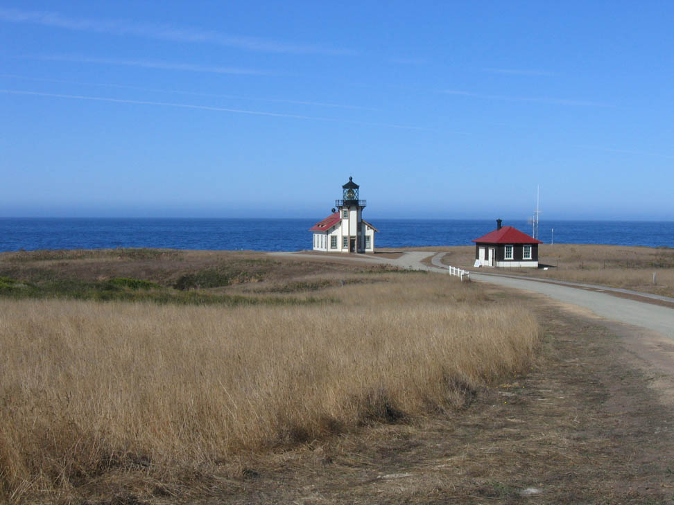
caption =Point Cabrillo Lighthouse
location = Caspar, California
coordinates = coord|39|20|54|N|123|49|33|W|region:US_type:landmark
yearbuilt =
yearlit = 1909
automated = 1973
yeardeactivated =
foundation = Concrete
construction = Wood
shape = Octagonal on fog signal building
marking = white building with red roof, black lens room and roof
height = 47 ft, 81 ft above sea level
currentlens = DCB-224
lens = Third order Fresnel lens
range = 22 nm
characteristic = Flashing white 10s. Emergency light of reduced intensity when main light is extinguished.
admiralty = G4362
ARLHS = USA-619
USCG = 6-0450

Point Cabrillo Light is a lighthouse in northern California, United States, between Point Arena and Cape Mendocino, just south of the community of Caspar. It should not be confused with the Point Loma Lighthouse, in San Diego, California, which lies within Cabrillo National Monument and is also sometimes called the Cabrillo lighthouse.

History

Point Cabrillo is named after the Spanish explorer Juan Rodríguez Cabrillo, although Cabrillo's voyage of exploration along the California coast did not reach as far north as the point.

Point Cabrillo Lighthouse was established in 1909, displaying a 3rd Order Standard Lens and Air Sirens. It is located about 1.5 miles from Fort Bragg, California. With the exception of a small barn all original buildings stand unaltered. In 1935, an air diaphone supertyfone sound signal was installed. The United States Coast Guard manned the station until 1973, when the lens was covered and a modern rotating beacon was mounted on a metal stand on the roof west of the lantern room. In 2002, California State Parks purchased the light station for four million dollars.

In 1991 the light station was added to the National Register of Historic Places.

External links

* [http://www.pointcabrillo.org/ Point Cabrillo Lighthouse and Preserve] .
* [http://www.parks.ca.gov/?page_id=22276 Point Cabrillo Light Station] . Official California State Parks page.
* [http://www.lighthousefriends.com/light.asp?ID=64 Lighthouse Friends: Point Cabrillo]
* [http://mendocinolighthouse.pointcabrillo.org/ Lighthouse Inn at Point Cabrillo] . Non-profit bed and breakfast that supports the Lighthouse restoration efforts.


Wikimedia Foundation. 2010.

Игры ⚽ Нужен реферат?

Look at other dictionaries:

  • Point Conception Light — Infobox Lighthouse caption = U.S. Coast Guard Archive location = Point Conception, California coordinates = coord|34|26|55|N|120|28|14|W|region:US type:landmark yearbuilt = 1856 yearlit = 1882 (current tower) automated = 1973 yeardeactivated =… …   Wikipedia

  • Point Loma Light (old) — Infobox Lighthouse name=Point Loma Light caption = The original Point Loma Lighthouse location = Cabrillo National Monument, San Diego, California. coordinates = coord|32|40|18|N|117|14|27|W|region:US type:landmark yearbuilt = 1855 yearlit = 1855 …   Wikipedia

  • Cabrillo — can refer to:* Juan Rodriguez Cabrillo, the first European to explore California.Places: * Cabrillo College in Aptos, California. * Cabrillo National Monument, near San Diego, California. * Point Cabrillo Light, a peninsular and lighthouse in… …   Wikipedia

  • Cabrillo National Monument — Infobox protected area | name = Cabrillo National Monument iucn category = III caption = locator x = 24 locator y = 110 location = San Diego, California, USA nearest city = lat degrees = 32 lat minutes = 40 lat seconds = 23 lat direction = N long …   Wikipedia

  • Juan Rodríguez Cabrillo — (ca. 1499 ndash; January 3, 1543) was a Portuguese explorer, known as João Rodrigues Cabrilho in Portuguese, noted for his exploration of the west coast of North America while sailing for Spain. Cabrillo was the first European explorer to… …   Wikipedia

  • Oakland Harbor Light — Coordinates: 37°46′52.69″N 122°14′37.65″W / 37.7813028°N 122.2437917°W / 37.7813028; 122.2437917 …   Wikipedia

  • Mare Island Light — Location San Pablo Bay, California Year first constructed 1873 Deactivated 1917 Construction Wood and Iron Tower shape Square attached to dwelling …   Wikipedia

  • Mile Rocks Light — Coordinates: 37°47′33.54″N 122°30′36.83″W / 37.79265°N 122.5102306°W / 37.79265; 122.5102306 …   Wikipedia

  • Chicago Harbor Light — Location Chicago, Illinois Coordinates 41°53 …   Wikipedia

  • Ballast Point Light — Infobox Lighthouse caption = location = Point Loma, California coordinates = yearbuilt = 1890 yearlit = automated = yeardeactivated = foundation = construction = shape = Square height = convert|34|foot|0 currentlens = lens = Fifth order Fresnel… …   Wikipedia

Share the article and excerpts

Direct link
Do a right-click on the link above
and select “Copy Link”