- Yerba Buena Light
Infobox Lighthouse
caption =
location =San Francisco Bay ,California
coordinates = coord|37.8073|N|122.3625|W
yearlit = 1875
automated = 1958
yeardeactivated =
foundation =Masonry
construction =Wood
shape = Octagonal & cylindrical
height = 25 ft
lens = Fifth orderFresnel lens
range =
characteristic = white light occulted every 4 s
admiralty = G4140
ARLHS = USA-908
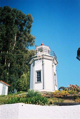
USCG = 6-4595Yerba Buena Lighthouse is a
lighthouse inCalifornia ,United States , in theSan Francisco Bay onYerba Buena Island ,California History
The island’s lighthouse connection began in 1873 when the Lighthouse Service moved the district's depot from Mare Island to the southeast side of Yerba Buena Island. In 1875 construction was completed on the 25 foot tower with a fifth order Fresnel lens. In 1886 another fifth order lens was replaced the previous one. In 1933, a tunnel was bored through Yerba Buena Island to serve as a link between the east and west sections of the Bay Bridge. The light was automated by the
United States Coast Guard in 1958. It is currently an active aid to navigation and not open to the public.Yerba Beuna Island was formerly known as Goat Island for the goats that were pastured on the island in the gold rush days. The name was retired in 1931 when the Spanish name was restored.
Even though the station is in very close proximity to the Bay Bridge, the lighthouse remains operational. The keeper’s quarters are now the home of the Coast Guard District Commander.
Gallery
External links
* [http://www.uscg.mil/hq/g-cp/history/WEBLIGHTHOUSES/LHCA.html USCG site]
Wikimedia Foundation. 2010.