Point Fermin Light

Point Fermin Light

Infobox Lighthouse


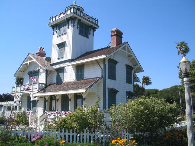
caption = Point Fermin building
location = Point Fermin, California
coordinates = coord|33.7054|N|118.2937|W
yearbuilt = 1874
yearlit = 1874
automated =
yeardeactivated = 1942
foundation = Brick
construction = Wood Frame
shape = Square Cylindrical
height = 30 ft
currentlens =
lens = Fourth order Fresnel lens
range =
characteristic =
ARLHS = USA-621
USCG = 6-0140

Point Fermin is a lighthouse on Point Fermin in San Pedro, California.

History

The original fourth order Fresnel lens was removed in 1942 and a wood replica lantern was installed in 1974. The lighthouse was saved from demolition in 1972 and refurbished in 1974, and a new lantern room and gallery were built by local preservationists. In 1972, the light was added to the National Register of Historic Places.

Historical Information from Coast Guard web site:
*Point Fermin Light was built in 1874 with lumber from California redwoods.
*In 1941 the light was extinguished and the lantern room and gallery were removed. They were replaced by a lookout shack that remained for the next 30 years.
*In 1972 the light was added to the National Register of Historic Places.
*The light fell into disuse and disrepair. A new lantern room and gallery were built in 1974.
*The building has now been restored to its original beauty and is open to the public. For more info go to www.pointferminlighthouse.org.

ee also

* List of Los Angeles Historic-Cultural Monuments in the Harbor area

External links

* [http://www.uscg.mil/hq/g-cp/history/WEBLIGHTHOUSES/LHCA.html Coast Guard entry]


Wikimedia Foundation. 2010.

Игры ⚽ Нужен реферат?

Look at other dictionaries:

  • Point Adams Light — Infobox Lighthouse caption = location = south of Columbia Bar coordinates = coord|46.188333| 123.977778 yearlit = 1875 automated = yeardeactivated = 1899 foundation = probably brick cite web url = http://www.rudyalicelighthouse.net/NWLts/PtAdams/P… …   Wikipedia

  • Oakland Harbor Light — Coordinates: 37°46′52.69″N 122°14′37.65″W / 37.7813028°N 122.2437917°W / 37.7813028; 122.2437917 …   Wikipedia

  • Mare Island Light — Location San Pablo Bay, California Year first constructed 1873 Deactivated 1917 Construction Wood and Iron Tower shape Square attached to dwelling …   Wikipedia

  • Mile Rocks Light — Coordinates: 37°47′33.54″N 122°30′36.83″W / 37.79265°N 122.5102306°W / 37.79265; 122.5102306 …   Wikipedia

  • Maritime history of California — History of California This article is part of a series Timeline …   Wikipedia

  • National Register of Historic Places listings in Los Angeles, California — For places listed on the National Register in the rest of Los Angeles County, see National Register of Historic Places listings in Los Angeles County, California. Map of all coordinates from Google Map of all coordinates from Bing …   Wikipedia

  • Lighthouses in the United States — This United States has hundreds of lights as well as light towers, range lights, and pier head lights. Michigan has the most lights of any state with over 130. See also: Lightvessels in the United States, lightvessel, List of lighthouses and… …   Wikipedia

  • San Pedro, Los Angeles, California — San Pedro is a beach community within Los Angeles, California, USA. It was annexed in 1909 and is a major seaport of the area. The town has grown from being dominated by the fishing industry to become primarily a working class town within the… …   Wikipedia

  • Natalie Schafer — in the film Dishonored Lady (1947) Born November 5, 1900(1900 11 05) Red Bank, New Jersey, U.S …   Wikipedia

  • Sam Anno — NFL PlayerCoach name=Sam Anno DateOfBirth= birth date and age|1965|01|26 Birthplace= Silver Spring, Maryland DateOfDeath= PlaceOfDeath= Position= Linebacker College= Southern California DraftedYear= DraftedRound= Awards= Honors= 1989 NFL Special… …   Wikipedia

Share the article and excerpts

Direct link
Do a right-click on the link above
and select “Copy Link”