- Como, Minneapolis
-
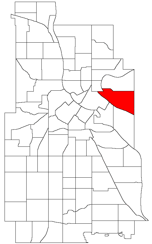
Como Nickname(s): Southeast Como Location of Como within the U.S. city of Minneapolis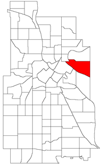
Country United States State Minnesota County Hennepin City Minneapolis Community University Population (2000)[1][2] - City 5,691 - Urban 387,970 - Metro 3,502,891 Time zone CST (UTC-6) - Summer (DST) CDT (UTC-5) ZIP code 55414 Area code(s) 612 Historical populations Census Pop. %± 1980 5,083 — 1990 5,617 10.5% 2000 5,691 1.3% 2010 6,288 10.5% Como is a neighborhood within the University community of Minneapolis. It is sometimes referred to as Southeast Como, since it is in Southeast Minneapolis, and possibly to differentiate it from the Como neighborhood in neighboring Saint Paul. Its boundaries are East Hennepin Avenue to the north, 33rd Avenue Southeast (the eastern city limit) to the east, the Southeast Industrial Area to the south, and Interstate 35W to the west.
Como features many amenities for its residents: Van Cleve Park Community Center, the Como Student Community Co-op, the University Childcare Center, Dar Al-Farooq mosque, SE Christian Church, and the Como Evangelical Free Church. The #3 busline is convenient to all who live in Como and we are minutes from Downtown Minneapolis, all of the University of Minnesota Twin Cities campuses, and Downtown St. Paul.
Trivia
- Como Avenue, which forms the spine of the residential neighborhood was originally a Territorial Road laid out in 1851, called the Willow River Road (Willow River is today's Hudson, WI).
- Later, when St. Paul named Lake Como and it became a popular recreational spot, the section of the WillowRiver/Hudson Road that led to the lake from Minneapolis became known as the Como Road.
- The first residential blocks were platted in 1882 by James Tallmadge Elwell.
- Maria Sanford, the first female professor at the U of M, lived in the neighborhood and was active in the community church.
- General Mills built their research laboratory here in 1930 and created Cheerioats, which is known as Cheerios today. In the early 1950’s, GM’s mechanical division invented the Ryan Flight Recorder, more famously known as the “black box”.
Coordinates: 44°59′06″N 93°13′08″W / 44.9850°N 93.2190°W[3]
References
- ^ "Twin Cities Region Population and Household Estimates, 2006" (PDF). Metropolitan Council. 2006-04-01. http://www.metrocouncil.org/metroarea/2006PopulationEstimates.pdf. Retrieved 2007-07-24.
- ^ "Table 2: Population Estimates for the 100 Most Populous Metropolitan Statistical Areas Based on July 1, 2006 Population Estimates: April 1, 2000 to July 1, 2006" (PDF). U.S. Census Bureau. 2007-04-05. http://www.census.gov/Press-Release/www/releases/archives/cb07-51tbl2.pdf. Retrieved 2007-04-16.
- ^ Como, Minneapolis, MN. Google Earth. Retrieved 2011-03-09.
External links
Minneapolis neighborhoods Calhoun-Isles Camden Cleveland · Folwell · Lind-Bohanon · McKinley · Shingle Creek · Victory · Webber-Camden
Central Longfellow Cooper · Hiawatha · Howe · Longfellow · Seward
Near North Harrison · Hawthorne · Jordan · Near North · Sumner-Glenwood · Willard-Hay
Nokomis Diamond Lake · Ericsson · Field · Hale · Keewaydin · Minnehaha · Morris Park · (Nokomis East) · Northrop · Page · Regina · Wenonah
Northeast Phillips Powderhorn Southwest Armatage · East Harriet · Fulton · Kenny · King Field · Linden Hills · Lynnhurst · Tangletown · Windom
University Cedar-Riverside · Como · Marcy-Holmes · Nicollet Island/East Bank · Prospect Park · University
Commercial areas Dinkytown · Downtown · Eat Street · 50th & France · Lyn-Lake · Midtown · Mills District · Stadium Village · Uptown

Beltrami Mid-City Industrial Area Marcy-Holmes 
Saint Paul, Minnesota  Como
Como 

University Prospect Park Categories:- Neighborhoods in Minneapolis, Minnesota
Wikimedia Foundation. 2010.