- Central, Minneapolis
-
For the neighborhood in south Minneapolis, see Central (neighborhood), Minneapolis.
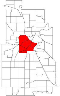
Central Location of Central within the U.S. city of Minneapolis Country United States State Minnesota Counties Hennepin Population (2000)[1][2] - City 24,149 - Urban 387,970 - Metro 3,502,891 Time zone CST (UTC-6) - Summer (DST) CDT (UTC-5) ZIP code 55401, 55402, 55403, 55404, 55405, 55411, 55415, 55454, 55487 Area code(s) 612 Historical populations Census Pop. %± 1980 18,952 — 1990 21,158 11.6% 2000 24,149 14.1% 2010 29,725 23.1% The Central community in Minneapolis is located in the central part of the city, consisting of 6 smaller official neighborhoods, and includes Downtown Minneapolis, the central business district. It also includes some high-density residential areas surrounding it, excluding areas east of the Mississippi River.
Official neighborhoods in the Central community
- Downtown East
- Downtown West where most of the high-rise office buildings are located
- Elliot Park
- Loring Park
- North Loop commonly referred to as the Warehouse District
- Stevens Square/Loring Heights
Coordinates: 44°58′35″N 93°16′26″W / 44.9763°N 93.2739°W[3]
See also
References
- ^ "Twin Cities Region Population and Household Estimates, 2006" (PDF). Metropolitan Council. 2006-04-01. http://www.metrocouncil.org/metroarea/2006PopulationEstimates.pdf. Retrieved 2007-07-24.
- ^ "Table 2: Population Estimates for the 100 Most Populous Metropolitan Statistical Areas Based on July 1, 2006 Population Estimates: April 1, 2000 to July 1, 2006" (PDF). U.S. Census Bureau. 2007-04-05. http://www.census.gov/Press-Release/www/releases/archives/cb07-51tbl2.pdf. Retrieved 2007-04-16.
- ^ Central, Minneapolis, MN. Google Earth. Retrieved 2011-03-09.
Minneapolis neighborhoods Calhoun-Isles Camden Cleveland · Folwell · Lind-Bohanon · McKinley · Shingle Creek · Victory · Webber-Camden
Central Longfellow Cooper · Hiawatha · Howe · Longfellow · Seward
Near North Harrison · Hawthorne · Jordan · Near North · Sumner-Glenwood · Willard-Hay
Nokomis Diamond Lake · Ericsson · Field · Hale · Keewaydin · Minnehaha · Morris Park · (Nokomis East) · Northrop · Page · Regina · Wenonah
Northeast Phillips Powderhorn Southwest Armatage · East Harriet · Fulton · Kenny · King Field · Linden Hills · Lynnhurst · Tangletown · Windom
University Cedar-Riverside · Como · Marcy-Holmes · Nicollet Island/East Bank · Prospect Park · University
Commercial areas Dinkytown · Downtown · Eat Street · 50th & France · Lyn-Lake · Midtown · Mills District · Stadium Village · Uptown
Categories:- Communities in Minneapolis, Minnesota
- Minnesota geography stubs
Wikimedia Foundation. 2010.

