- Downtown East, Minneapolis
-
Downtown East Location of Downtown East within the U.S. city of Minneapolis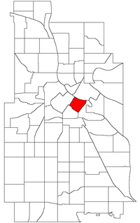
Country United States State Minnesota County Hennepin City Minneapolis Community Central Population (2000)[1][2] - City 128 - Urban 387,970 - Metro 3,502,891 Time zone CST (UTC-6) - Summer (DST) CDT (UTC-5) ZIP code 55401, 55415, 55454 Area code(s) 612 Downtown East is an official neighborhood in Minneapolis, Minnesota, United States part of the larger Central community. Its boundaries are the Mississippi River to the north, Interstate 35W to the east, 5th Street South to the south, and Portland Avenue to the west. It is bounded by the Downtown West, Elliot Park, and Cedar-Riverside neighborhoods. The Marcy-Holmes neighborhood is on the other side of the river, but there is no direct automobile connection between the two neighborhoods. There is a pedestrian and bicycle connection via the Stone Arch Bridge. Downtown East is home to the H.H.H. Metrodome, where the Minnesota Twins (MLB baseball), Minnesota Vikings (NFL football), and Minnesota Gophers (NCAA University of Minnesota football) have all played home games. As of 2009, the Minnesota Golden Gophers moved into the new TCF Bank Stadium on the University of Minnesota Campus. Additionally, The Minnesota Twins moved into new Target Field at the start of the 2010 season.
Within Downtown East is the Mills District, which contains a number of former industrial properties left over from the days when Minneapolis was the flour milling capital of the world. Many old mills and factories are being converted to housing, bringing a residential population to a neighborhood that beforehand didn't have many residents. The neighborhood is also home to the Mill City Museum, Mill Ruins Park, and the new Guthrie Theater complex, which abandoned its old location near Loring Park during the summer of 2006.
The neighborhood is served by Downtown East/Metrodome station of the Hiawatha Line.
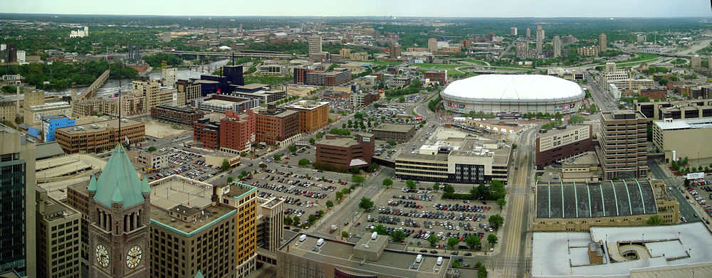 Downtown East: the arched bridge on the left is the Stone Arch Bridge crossing the Mississippi River; the dark blue building is the Guthrie Theater; the long straight span crossing the river behind it is the I-35W Mississippi River bridge which collapsed in August 2007. The domed stadium is the Metrodome; also in the photo is the headquarters of the Star Tribune, parts of Hennepin County Medical Center as well as several former mills (The clock tower in the foreground is a part of Minneapolis City Hall). The Downtown East/Metrodome Station of the Hiawatha Line sits by the arches in front of the Metrodome.
Historical populations Census Pop. %± 1980 70 — 1990 25 −64.3% 2000 128 412.0% 2010 1,254 879.7% Coordinates: 44°58′33″N 93°15′16″W / 44.9759°N 93.2545°W[3]
References
- ^ "Twin Cities Region Population and Household Estimates, 2006" (PDF). Metropolitan Council. 2006-04-01. http://www.metrocouncil.org/metroarea/2006PopulationEstimates.pdf. Retrieved 2007-07-24.
- ^ "Table 2: Population Estimates for the 100 Most Populous Metropolitan Statistical Areas Based on July 1, 2006 Population Estimates: April 1, 2000 to July 1, 2006" (PDF). U.S. Census Bureau. 2007-04-05. http://www.census.gov/Press-Release/www/releases/archives/cb07-51tbl2.pdf. Retrieved 2007-04-16.
- ^ Downtown East, Minneapolis, MN. Google Earth. Retrieved 2011-03-09.
External links
- Minneapolis Neighborhood Profile - Downtown East
- 7th Ward, City of Minneapolis
- Downtown Minneapolis Neighborhood Association
Minneapolis neighborhoods Calhoun-Isles Camden Cleveland · Folwell · Lind-Bohanon · McKinley · Shingle Creek · Victory · Webber-Camden
Central Downtown East · Downtown West · Elliot Park · Loring Park · North Loop · Stevens Square
Longfellow Cooper · Hiawatha · Howe · Longfellow · Seward
Near North Harrison · Hawthorne · Jordan · Near North · Sumner-Glenwood · Willard-Hay
Nokomis Diamond Lake · Ericsson · Field · Hale · Keewaydin · Minnehaha · Morris Park · (Nokomis East) · Northrop · Page · Regina · Wenonah
Northeast Phillips Powderhorn Southwest Armatage · East Harriet · Fulton · Kenny · King Field · Linden Hills · Lynnhurst · Tangletown · Windom
University Cedar-Riverside · Como · Marcy-Holmes · Nicollet Island/East Bank · Prospect Park · University
Commercial areas Dinkytown · Downtown · Eat Street · 50th & France · Lyn-Lake · Midtown · Mills District · Stadium Village · Uptown

Marcy-Holmes Downtown West 
Cedar-Riverside  Downtown East

Elliot Park Cedar-Riverside Categories:- Neighborhoods in Minneapolis, Minnesota


Wikimedia Foundation. 2010.