- Mikołów County
-
Mikołów County
Powiat mikołowski— County — 
Flag
Coat of armsLocation within the voivodeship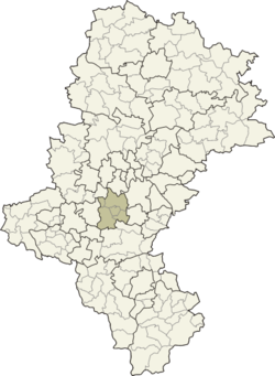
Coordinates (Mikołów): 50°10′N 18°54′E / 50.167°N 18.9°ECoordinates: 50°10′N 18°54′E / 50.167°N 18.9°E Country  Poland
Voivodeship Silesian Seat Mikołów Gminas Total 5 (incl. 3 urban)Area - Total 231.53 km2 (89.4 sq mi) Population (2006) - Total 91,022 - Density 393.1/km2 (1,018.2/sq mi) - Urban 79,128 - Rural 11,894 Car plates SMI Website http://www.powiat.mikolow.pl/ Mikołów County (Polish: powiat mikołowski) is a unit of territorial administration and local government (powiat) in Silesian Voivodeship, southern Poland. It came into being on January 1, 1999, as a result of the Polish local government reforms passed in 1998. Its administrative seat and largest town is Mikołów, which lies 12 kilometres (7 mi) south-west of the regional capital Katowice. The county also contains the towns of Łaziska Górne, lying 5 km (3 mi) south-west of Mikołów, and Orzesze, 11 km (7 mi) west of Mikołów.
The county covers an area of 231.53 square kilometres (89.4 sq mi). As of 2006 its total population is 91,022, out of which the population of Mikołów is 38,392, that of Łaziska Górne is 21,906, that of Orzesze is 18,830, and the rural population is 11,894.
Neighbouring counties
Mikołów County is bordered by the city of Ruda Śląska to the north, Katowice and Tychy to the east, Pszczyna County and Żory to the south, Rybnik County to the west and Gliwice County to the north-west.
Administrative division
The county is subdivided into five gminas (three urban and two rural). These are listed in the following table, in descending order of population.
Gmina Type Area
(km²)Population
(2006)Seat Mikołów urban 81.0 38,392 Łaziska Górne urban 20.2 21,906 Orzesze urban 82.9 18,830 Gmina Wyry rural 34.5 6,328 Wyry Gmina Ornontowice rural 15.1 5,566 Ornontowice References
Urban gminas 
Rural gminas Counties of Silesian Voivodeship City counties Katowice (capital) • Bielsko-Biała • Bytom • Chorzów • Częstochowa • Dąbrowa Górnicza • Gliwice • Jastrzębie-Zdrój • Jaworzno • Mysłowice • Piekary Śląskie • Ruda Śląska • Rybnik • Siemianowice Śląskie • Sosnowiec • Świętochłowice • Tychy • Zabrze • Żory
Land counties Categories:- Mikołów County
- Land counties of Silesian Voivodeship


Wikimedia Foundation. 2010.