- Lubliniec County
Infobox Settlement
name = Lubliniec County
native_name = Powiat lubliniecki
settlement_type = County
total_type = Total
image_shield = POL powiat lubliniecki COA.svg
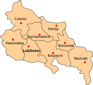
map_caption = Division into gminas
subdivision_type = Country
subdivision_name = POL
subdivision_type1 = Voivodeship
subdivision_name1 = Silesian
area_total_km2 = 822.13
population_total = 76628
population_as_of = 2006
population_density_km2 = auto
population_urban = 28639
population_blank1_title = Rural
population_blank1 = 47989
coor_type = Lubliniec
latd = 50
latm = 41
lats =
latNS = N
longd = 18
longm = 41
longs =
longEW = E
seat =Lubliniec
parts_type =Gmina s
parts = Total 8 (incl. 1 urban)
p1 =Lubliniec
p2 =Gmina Boronów
p3 =Gmina Ciasna
p4 =Gmina Herby
p5 =Gmina Kochanowice
p6 =Gmina Koszęcin
p7 =Gmina Pawonków
p8 =Gmina Woźniki
blank_name = Car plates
blank_info = SLU
website = http://www.lubliniec.starostwo.gov.pl/ __NOTOC__Lubliniec County ( _pl. powiat lubliniecki) is a unit of territorial administration and local government (powiat ) inSilesian Voivodeship , southernPoland . It was created onJanuary 1 ,1999 as a result of the Local Government Reorganization Act of 1998. Its administrative seat and largest town isLubliniec , which lies convert|54|km|mi|0 north-west of the regional capitalKatowice . The only other town in the county isWoźniki , lying convert|45|km|mi|0|abbr=on north-east of Lubliniec.The county covers an area of convert|822.13|km2|sqmi|1. As of 2006 its total population is 76,628, out of which the population of Lubliniec is 24,229, that of Woźniki is 4,410, and the rural population is 47,989.
Neighbouring counties
Lubliniec County is bordered by
Kłobuck County to the north-east,Częstochowa County andMyszków County to the east,Tarnowskie Góry County to the south,Strzelce County to the south-west, andOlesno County to the north-west.Administrative division
The county is subdivided into eight
gmina s (one urban, one urban-rural and six rural). These are listed in the following table, in descending order of population.References
* [http://www.stat.gov.pl/gus/45_655_PLK_HTML.htm Polish official population figures 2006]

Wikimedia Foundation. 2010.