- Mukutmanipur
-
Mukutmanipur — town — Coordinates 22°56′58″N 86°48′17″E / 22.9495810°N 86.8046520°ECoordinates: 22°56′58″N 86°48′17″E / 22.9495810°N 86.8046520°E Country India State West Bengal District(s) Bankura Time zone IST (UTC+05:30) Website bankura.gov.in/ 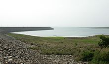 Mukutmonipur Dam
Mukutmanipur (Bengali: মুকুটমণিপুর) is a town in Bankura district of West Bengal, India. It is located at the confluence of the Kangsabati and Kumari rivers close to the Jharkhand border.
Contents
Geography
Kangsabati project
In 1956, a giant water dam reservoir was planned at Mukutmonipur, [about 12 km from Khatra town in the district of Bankura, WB], under a big vision mooted by the then CM of Bengal Dr Bidhan Ch. Roy. The Mukutmonipur dam was planned to provide major irrigation facilities to 8,000 square kilometres of agricultural land, stretched across Bankura, Purulia, Paschim Medinipur and parts of upper Hooghly. [1] Approximately two kilometres from the lake is the Bangopalpur Reserve Forest, a home of many species of flora and fauna.
Tourist centre
Mukutmonipur and Jhilimili nearby are major tourist attractions visited by more than a lakh (100 000) visitors. The second biggest earth dam of India is located in Mukutmonipur 55 km away from Bankura. According to one description, “green forests surround the vast bluish tract of water, and the hillocks are picturesque. The place is very famous for its superb natural beauty. The undulating terrain along the southern edge of the Kangsabati water reservoir spreads as a three-dimensional necklace in green and terracotta.” The SDO, Khatra, Mr Sanjay Vansal said: “We have got a Rs 80 lakh composite UNDP project for Mukutmonipur. The project has been conceived to promote tourism and improve the condition of the tribal artisans devoted to the craft work with bamboo sticks and saboi grass.” [2] Approximately two kilometers from the lake is the Bangopalpur Reserve Forest, a home of many species of flora and fauna. Four kilometres from the dam is the ancient town of Ambikanagar, once an important place of pilgrimage for Jains. However, a flood destroyed most of what remained in 1898.
Mukutmanipur, a quaint serene place, which is home to the world’s reportedly longest (10.8 km) man-made mud-banked fresh water barrage that canalises Kangshabati & Kumari rivers into the three drought affected districts ie. Bankura, Purulia & Midnapore for irrigation in the summer months.
Transport
The Union Railway Minister laid the foundation stone of the new 47 km Bankura-Chhatna-Mukutmanipur line in 2005.[3][4]
How to Get There
Train service available from Howrah station till Bankura station. From Bankura one can take a bus till Mukutmanipur itself. Train journey time from Howrah to Bankura: 4.5 hrs; bus journey time from Bankura to Mukutmanipur: 2 hrs. Buses are also available directly from Calcutta to Mukutmanipur, with journey time 8-9 hrs. Non-A/C pushback buses cost Rs 110-130/- for the Calcutta-Mukutmanipur direct journey; while the Bankura-Mukutmanipur stretch will cost Rs 30/-. A few State Transport buses are also available.
External links
- Jharkhand Tourism webpage
- Calcutta English daily Telegraph review of Mukutmanipur
- West Bengal Tourism webpage
References
Bankura district topics General Bankura horse • Bargi • Bhadu • Bishnupur Gharana • Culture of Bankura district • Dharmathakur • Gajan • Geography of Bankura district • History of Bankura district • Jainism in Bengal • Kangsabati Project • Mejia Thermal Power Station • Piardoba AirfieldPeople Subdivisions Bankura Sadar • Bishnupur • KhatraTerritories Bardhamanbhukti • Dandabhukti • Dhalbhum • Jungle Mahals • Mallabhum • Rarh region • Samantabhum • TungbhumLocations
other than cities and townsBahulara • Dharapat • Dihar • Ekteswar • Harmasra • Jayrambati • Jhilimili • Mukutmanipur • Panchmura • Pakhanna • SonatapalMunicipalities Community development blocks Rivers Hills Transport Institutes of higher learning Lok Sabha constituencies Bankura • BishnupurVidhan Sabha constituencies Former Vidhan Sabha
constituenciesGangajalghati • IndpurSee also Cities and towns in Bankura district • People from Bankura district • Villages in Bankura district • Damodar ValleyOther districts Bardhaman • Birbhum • Cooch Behar • Dakshin Dinajpur • Darjeeling • Hooghly · Howrah • Jalpaiguri • Kolkata • Malda • Murshidabad • Nadia • North 24 Parganas • Paschim Medinipur • Purba Medinipur • Purulia • South 24 Parganas • Uttar DinajpurCategories:- Bankura district
- Dams/Barrages in West Bengal


Wikimedia Foundation. 2010.