- Ledringhem
-
Not to be confused with Ledinghem, a village in the Pas-de-Calais department.
Ledringhem
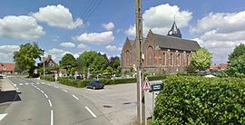
View of Ledringhem church, graveyard and town hall 

 LedringhemLocation within Nord-Pas-de-Calais region
 Ledringhem
Administration Country France Region Nord-Pas-de-Calais Department Nord Arrondissement Dunkirk Canton Wormhout Intercommunality Yser Mayor Christian Delassus
(2008–2014)Statistics Elevation 11–26 m (36–85 ft)
(avg. 19 m/62 ft)Land area1 7.01 km2 (2.71 sq mi) Population2 507 (1999) - Density 72 /km2 (190 /sq mi) INSEE/Postal code 59338/ 59470 1 French Land Register data, which excludes lakes, ponds, glaciers > 1 km² (0.386 sq mi or 247 acres) and river estuaries. 2 Population without double counting: residents of multiple communes (e.g., students and military personnel) only counted once. Coordinates: 50°51′19″N 2°26′30″E / 50.8552777778°N 2.44166666667°E
Ledringhem is a commune in the Nord department in northern France.
It is situated also in the ancient territory of the French Flandre, in the Houtland (or woodland, with the cities of Cassel and Hazebrouck) in the Franse Westhoek (French Western corner) where Flemish was still spoken until recently.
The residents of Ledringhem are called Ledringhemois.
- Name in other languages
Contents
Geography
 Ledringhem in the arrondissement of Dunkirk
The village is about 4 kilometres (2.5 mi) southwest of the small town of Wormhout, and approximately 10 kilometres (6.2 mi) north of Cassel. Bigger cities are Dunkirk further to the north and Hazebrouck further to the south.
Ledringhem is crossed by the small river Peene Becque,[1] a tributary of the Franco-Belgian river Yser and there is one shorter tributary, the Lyncke Becque[2], passing closer to the village center. Other small rivers are Trommels Becque, Putte Becque, Platse Becque and Kaliszewski Becque.[3]
The climate in Ledringhem is oceanic with a mild summer (Köppen Classification : Cfb).[4]
Village limits
The river Peene Becque constitutes the southern border between Ledringhem and Arnèke and Zermezeele. It is also the South-Eastern limit with Wormhout until the limit crosses a field between rue des postes and rue de la Forgé. The North-Eastern limit with Wormhout is rue Louis Patoor. The village Western limit with Arnèke is Voie romaine (D52). The Northern limit with Esquelbecq is chemin de Rubrouck.

Esquelbecq Arnèke 
Wormhout  Ledringhem

Zermezeele Place names
 Map of Ledringhem
The village center consists of the main square (La Place), the church, the cemetery, the town's hall and the village park, forming an islet nested in a large turn of the route de Wormhout.
There are two subdivisons:
- La campagnarde is a more modern part of the village in comparison with the rest of the built patrimony, situated in the west.
- Another modern neighborough dating 2005 is situated at the former place of the village windmill, destroyed during World War II, at the east. The newly built road serving this neighborhood is called route du moulin (wind mill road).
Other locations (Lieux-dits) are called Bas de la Plaine, La Belette, La Butte, La Motte, La Plaine, La Potence, Le Baron, Les Grenouilles, Les Tambours, Oost Houck (coin de l'Est), Planckeel (Planckael), Sainte Anne, Tampon court and Zinkepit.
Ledringhem is situated on the D55 road (actually called route de Wormhout towards Wormhout in the North-East direction and route d'Arneke in the West direction).
Other smaller roads include rue Henri Wallaert, chemin d'Esquelbecq, petit chemin d'Esquelbecq (north directions), chemin de Bodeye, chemin de la chapelle, chemin de la pâture grasse, chemin de Steenvoorde, chemin des postes, chemin des prairies, chemin d'Heenhout, chemin du moulin, chemin du tétard borne and voie nouvelle.[5][6]
The village is a little off the ancient Roman road, now D52, roughly North-South in direction.Heraldry
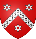
The arms of Ledringhem are blazoned :
Gules, a chevron ermine between 3 pierced mullets of six argent.History
The origins of the village are unclear.
Naming and first appearances in texts
The current name "Ledringhem" could be of Frankish origin, with the hem particle meaning "Home" (cf: in other languages heim/ham)" and Ledring being the genitive form of Leodro, a common given name at the time,[7] who could have been a local chief.
Another explanation for the name etymology is Liuthari|ing|haim = home of Luithari's people.[8]
Another explanation is that the name comes from the Latin form (Ledera) of the name of a local brook called the Leder. This explanation, given in tome II, page 572 of Flandria Illustrata (1641), and though doubtfull, is also provided for the name of nearby village Lederzeele. It comes from Sanderus (1586-1664) who wrote, citing Malbrancq, : Lederam pluribus ab ortu suo pagis nomem commuicantem.[9][10][11]
For Anglo-Saxon history specialist Daniel Henry Haigh (1819—1879), the village could share a common toponymy with the civil parish of Letheringham in Suffolk, England.[12]723 : « Leodringas mansiones infra Mempisco » in the Latin-written saint Bertin's carticulary in the first part attributed to Folquin (or Saint Folquin, died 14 December 855 in Esquelbeques).[13] This text relates a sale act written in 723 where the names given are Leodringas mansiones or Leodringae mansiones. It is thought that Leodringas is a Latin form of Ledring while mansiones were official stopping places on a Roman road and Mempisco refers to the Pagus Mempiscus, an administrative subdivision in the territory of the Flanders at the time. In this sale act, the owner, who is described as having a considerable wealth, was named Rigobert, whereas the buyer was Sitdiu's (Saint-Omer) abbot.[14][15]
1207 : « Lidringhere » in titre de l'abbaye de Blandecques (Mir.)
1330 : « Ledringhien » in manuscrit de la bataille de Cassel[16]
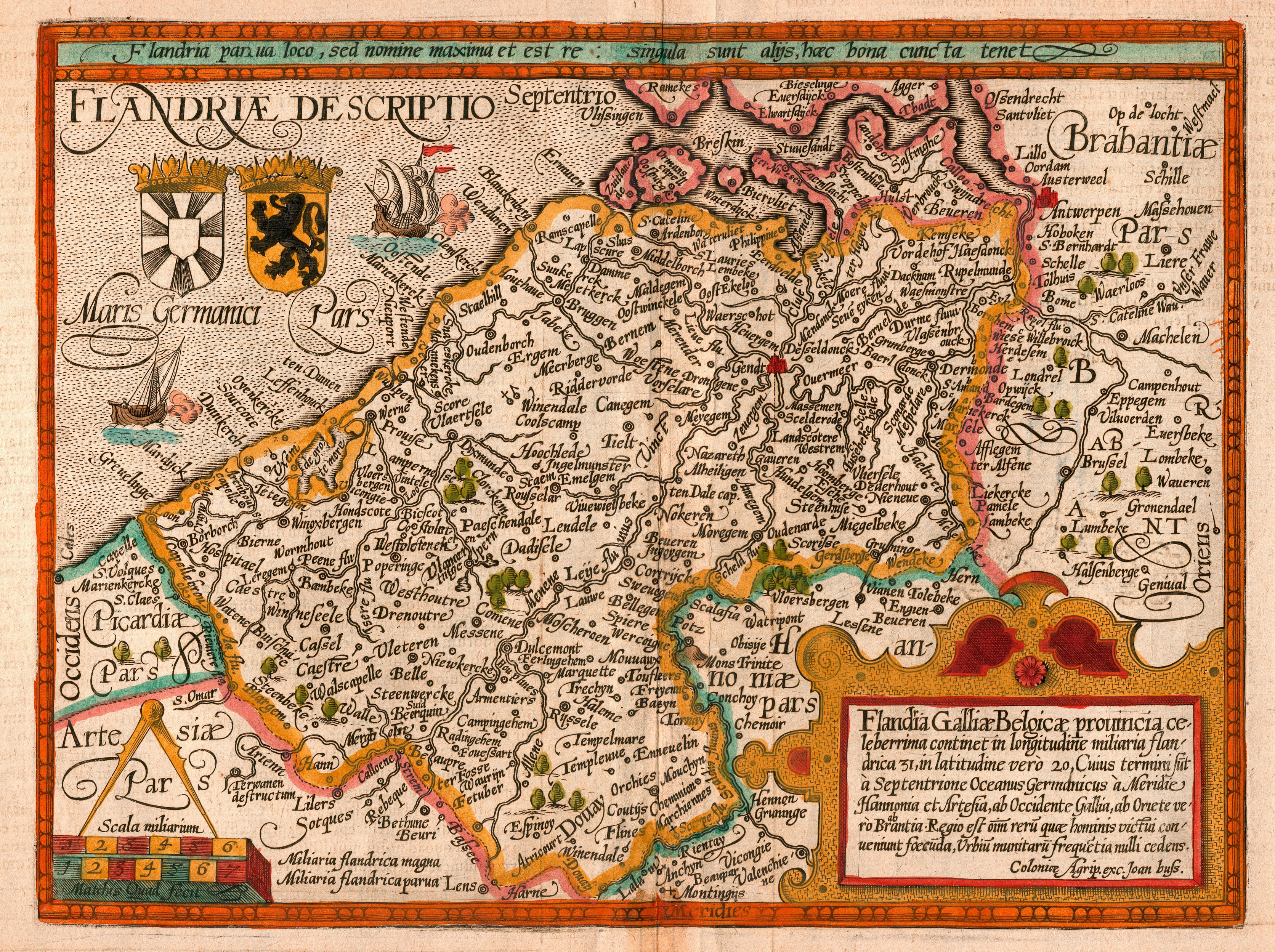
1614-1616 : « Leodredingas » as an alternative form of the Latin name Leodringas[17] by Locrius (Ferreolus or Philippus) in Chronicum belgicum (Chronicon belgicum, ab anno CCLVIII ad annum usque M.D.C. continuo perductum.) Atrecht [18][19]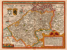 1609 map of the county of Flanders by Matthias Quad (cartographer) and Johannes Bussemacher (engraver & publisher, Cologne)
1609 : « Leregem » on Matthias Quad's map Flandiae Descriptio.[20]
1639 : « Leodringas » in Jacques Malbrancq's De Morinis et Morinorum rebus, sylvis, paludibus, oppidis, regia comitum prosapia ac territoriis, Tomus Primus, ab anno ante Christum 309 ad annum eiusdem 751, Tornaci Nerviorum, 1639[9]
1645 : « Leregem » on Joan Blaeu's map Artesia Comitatus Artois.[21]
1757 : « Ledrenghem » on the 14th sheet of Cassini's map, the village is pictured as a parish with a wooden wind mill.[22]Gaulish times
 Map of Gallic tribes in Gallia Belgica.
The village could have been occupied since Gaulish times. At that time, the village territory was dry land (or moorland), to the contrary of other territories which were underwater, in the "plaine maritime" (polder region of Les Moëres) part of the French Flandre.
The nearby presence of a Roman road (now voie romaine - D52) from Cassel and leading to the sea could have been a reason for an early settlement. This road could have preceded the Romans.[23]
- 1852 Ledringhem's treasure discovery
As a proof of possible gaulish origins, a hoard was discovered in 1852 in Ledringhem. This treasure has been estimated by Jérémie Landron (1840–1904), a pharmacist-chemist-gold-and-silver assayer, to be composed with 35 000 golden small coins, described as staters, and locally known as Ledringhem's buttons (boutons de Ledringhem).[24]
The coins were retrieved in a 18 liters vase, that has been lost, by two workers cleaning a farm cesspit. Each coin was 18 mm wide and weighed approximately 6 grams.
Half of the coins were reddish, color due to a higher richness in copper in the gold-silver-copper alloy, the remaining coins being yellow-white-colored. They presented a running wild horse representation on one of the two faces.[25]
It has been hypothesized that this treasure could have been hidden underground and never been recovered by its Morini or Menapian owners, during troubled times like during the Gallic Wars.[26]
Roman time
 Map of Roman Empire in the second century (116), with Gallia Belgica province highlighted in red.
Julius Caesar conquered the Belgae, beginning in 57 BC. He marched into the territory of the Suessiones and besieged the town of Noviodunum (Soissons). Seeing the Romans' siege engines, the Suessiones surrendered, whereupon Caesar turned his attention to the Bellovaci, who had retreated into the fortress of Bratuspantium (between modern Amiens and Beauvais). They quickly surrendered, as did the Ambiani.
The Nervii, along with the Atrebates and Viromandui, decided to fight (the Atuatuci had also agreed to join them but had not yet arrived). They concealed themselves in the forests and attacked the approaching Roman column at the river Sabis (previously thought to be the Sambre but recently the Selle is thought to be more probable). Their attack was quick and unexpected. The element of surprise briefly left the Romans exposed. Some of the Romans did not have time to take the covers off their shields or to even put on their helmets. However Caesar grabbed a shield, made his way to the front line, and quickly organised his forces. The two Roman legions guarding the baggage train at the rear finally arrived and helped to turn the tide of the battle. Caesar says the Nervii were almost annihilated in the battle, and is effusive in his tribute to their bravery, calling them "heroes".
The Atuatuci, who were marching to their aid, turned back on hearing of the defeat and retreated to one stronghold, were put under siege, and soon surrendered and handed over their arms. However the surrender was a ploy, and the Atuatuci, armed with weapons they had hidden, tried to break out during the night. The Romans had the advantage of position and killed four thousand. The rest, about fifty-three thousand, were sold into slavery.
In 53 BC the Eburones, led by Ambiorix, along with the Nervii, Menapii and Morini, revolted again and wiped out 15 cohorts, only to be put down by Caesar.
The Belgae fought in the uprising of Vercingetorix in 52 BC.
The Menapii again rebelled along with their neighbours, the Morini, in 30 or 29 BC. The Roman governor of Gaul, Gaius Carrinas, successfully quelled the rebellion and the territory of the Menapii was subsequently absorbed into the Roman province of Gallia Belgica.
After their final subjugation, Caesar combined the three parts of Gaul, the territory of the Belgae, Celtae and Aquitani, into a single unwieldy province (Gallia Comata, "long-haired Gaul") that was reorganized by the emperor Augustus into its traditional cultural divisions. The population was partially romanised from the 1st to 3rd century.
Frankish Empire
In Gaul, the Franks, a fusion of western Germanic tribes whose leaders had been strongly aligned with Rome since the 3rd century, subsequently entered Roman lands more gradually and peacefully during the 5th century, and were generally endured as rulers by the Roman-Gaulish population.
The current territory of the village of Ledringhem was part of Francia, the territory held by Franks, in 481. It became part of West Francia in 843, and more accurately part of Neustria.
From 830 until around 910, the Vikings invaded Flanders. After the destruction caused by Norman and Magyar invasion, the eastern part of the region fell under the eyes of the area's princes.
Middle Ages
 Map of the County of Flanders in the late 14th century.
During the Middle Ages, Ledringhem was one the 6 fiefs in the Bergues fiefdom, composed out of 24 villages.[27] under the jurisdiction of Counts of Flandres. Esquelbecques and Ledringhem were parts of the same fief, but both villages had their own town magistrates.[28]
From 1323 to 1328 people from Ledringhem took part to the peasant revolt in Flanders and five of them died in 1328 during the Battle of Cassel.[16]
In 1436, Wautier de Ghistelles was seigneur d'Ekelsbeke et de Ledringhem (Lord of Esquelbecq and Ledringhem) and governor of La Madeleine hospital in Bierne.[29]
Habsburg Netherlands
Ledringhem was part of the Habsburg Netherlands (1482 to 1556/1581).
During the Dutch Reformation Beeldenstorm iconoclasm movement, an episode took place in Ledringhem on Friday 16 August 1566.[30] A depiction of the events is given in[31]:
Jan de Druck was a busy iconoclast. He participated in attacks in Broxeele, Eecke, North and South Berkijn, and Ledringhem, for which he was condemned to death on october 28, 1567, by Alba's special law court, the council of Troubles. His crimes centrered on destruction of religious art and objects in parish churches in mid-August 1566: ... He also ransacked several altars at Ledringhem, stealing money amounting to 3 or 4 Parisian pounds and intended "for common devotion." ... Druck's deeds mirror those of other individuals and small groups; at Ledringhem, on September 10, a crowd of about thirty-two seized the priest's house, eating and drinking heartily before they settled down for the night there. Refreshed, the next morning they sacked the local parish church, destroying four altars. They scattered for the balance of the day, some going to Ekelsbeke, other to Arnèke, both sets listening to sermons, only to return at nightfall, this time to the chaplain's house,where they had something to eat and pocketed four candles. Afterward, they randomly searched private houses looking for objects the churchwardens might have hidden, or domestic altars or shrines. The next morning, they continued their efforts, overturning basins of holy oil, smashing up more altars, and shredding the priest's and chaplains's books. As a parting shot, they derisively cut up the chaplain's bonnet.
Spanish Netherlands period
Ledringhem was part of Southern Netherlands (Dutch: Zuidelijke Nederlanden, Spanish: Países Bajos del Sur, French: Pays-Bas du sud), a part of the Low Countries controlled by Spain (Spanish Netherlands, 1579–1713), then by Austria after the signing of the Treaty of Utrecht in 1713 (Austrian Netherlands, 1713–1794).
From February to May 1638, a plague episode made victims in Ledringhem.
French annexation
Ledringhem became a French possession following the Treaty of Aix-la-Chapelle in 1668 with the fall of the Châtellenie of Bergues, at that time part of the Spanish Netherlands, is given to French king Louis XIV.
Another Battle took place in Cassel in 1677, where Louis XIV took hold of the town of Saint Omer.French Revolution
After the French Revolution, French rule has been secured with revolutionary victory in the Battle of Hondshoote in 1793 against English and Austrian troops wanting to get hold of Dunkirk port.
In 1794 the entire region of the Spanish/Austrian Netherlands was overrun by France ending the existence of this territory as such. This was resisted by the Flamingant movement organized by Roman Catholic clergy. Austria confirmed the loss of its territories by the Treaty of Campo Formio, in 1797.Henri-Louis de Guernoval, marquis d'Esquelbecq (1729–1801) (marquis de Ledringhem), captain in second of Louis XIV Royal-Cravattes regiment was the last of the nobility member to administer Ledringhem.
First French Empire
Ledringhem became part of the First French Empire 1810 Napoleonic Nord département.
World wars
Shrapnel, like canon shells and bullet casings can still be found in and around the fields here. They are usually found by farmers ploughing, and date back to World Wars.
- World War I
German Schlieffen Plan in 1914 was to invade Belgium to better attack France to the north.
Thus, at the beginning, the war was a mobility war. At that time, British horse-riding 20th Hussars were in Ledringhem the 7th of May 1915.[32]
As the war turned into a trenches war with the front established to the east near Ypres, Ledringhem served as a resting and training place (billet) to the rear for the 1st Royal Marine Battalion from the 14th to the 22nd November 1917.[33]
- World War II
A violent battle took place in Ledringhem during the Battle of France in May 1940, which involved British soldiers against German troops. On the 27th to the 29th of May 1940, the British 5th Glosters got separated from the rest of the British forces in Ledringhem and became involved in fierce combats against motorized German troops. Several casualties among the British soldiers, including officers[34][35] and also French civilians, occurred during the fight. Nevertheless, the village was never conquered by the Germans at that time, and finally the British escaped to embark in Dunkirk evacuation during Operation Dynamo.[36] There is a Military Cemetery located at the site of the battle. Other casualties were made by Leibstandarte SS Adolf Hitler by killing prisoners gathered in a barn at La Plaine au Bois in Wormhoudt on Tuesday May 28, 1940.[37]
Also during that period, the windmill in Ledringhem has been burnt down. The head of the windmill served to repair the Drievenmeulen[38] in Steenvoorde.
War monuments
The French Monument to the Deads (Monument aux Morts) presents 25 names, 15 of which being French soldiers killed during the first World War, the other ten being civilian victims during World War II.[39] It is situated in the cemetery near the church.
In the British military part of the cemetery containing 52 graves, there is a Cross of Sacrifice.[40]
Historical populations Year Pop. ±% 1793 710 — 1800 700 −1.4% 1806 710 +1.4% 1821 704 −0.8% 1831 739 +5.0% 1836 719 −2.7% 1841 704 −2.1% 1846 702 −0.3% 1851 689 −1.9% 1856 658 −4.5% 1861 650 −1.2% 1866 635 −2.3% 1872 659 +3.8% 1876 649 −1.5% 1881 612 −5.7% 1886 599 −2.1% 1891 603 +0.7% 1896 523 −13.3% 1901 478 −8.6% 1906 487 +1.9% 1911 485 −0.4% 1921 480 −1.0% 1926 466 −2.9% 1931 446 −4.3% 1936 433 −2.9% 1946 431 −0.5% 1954 408 −5.3% 1962 399 −2.2% 1968 418 +4.8% 1975 403 −3.6% 1982 522 +29.5% 1990 533 +2.1% 1999 507 −4.9% 2006 649 +28.0% From the year 1962 on: population without double counting Source: INSEE[41]
Source : Cassini
2006 : provisional population estimation by InseeAdministration
Mayors :
- Christian Delassus : 2001-2008, 2008–2014
- Christian Deblock
Ledringhem doesn't participate in a twinnage program with a foreign country municipality.
Transportation
There is a bus stop, for pupils to go to collège in Wormhout, or the high school in Hazebrouck, or to go to Wormhout.
The nearest train stations are in Arnèke and Esquelbecq.
Accommodations
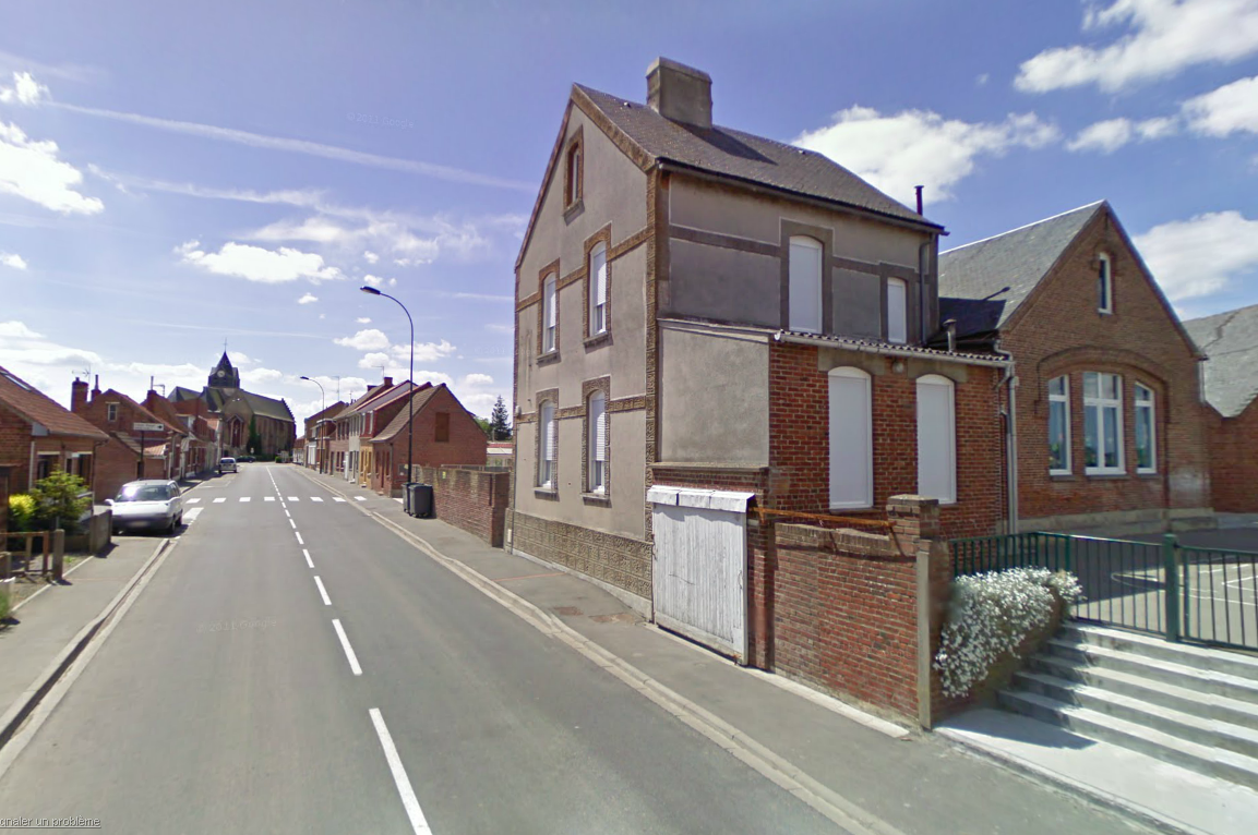
 View on Ledringhem's school
There is a municipal school in Ledringhem, a multi-sport stadium and a feasting hall (salle des fêtes).
There is le Trou Flamand estaminet[44] (Flemish-style café-restaurant)[45] which is also a general store situated on the main square and the inn Auberge Du Kok-smid situated along route de Wormhout.[46]
Economy
The village main resources are agriculture productions. These include cereals (wheat, barley, oat), flax, fodder (mangel) and sugar beets, potatoes, horticulture and cattle raising (cows, pigs, fowls, ...).
There are also a few other businesses including a general practitioner.[47]
Social life
List of associations in Ledringhem:[48]
- Alcyon, Association pour le rayonnement de la francophonie, help to French speaking students
- Association Audrey 59 Steven
- Association des parents d'élèves de l'école publique de Ledringhem (APEEPL), pupil's parents association
- Association Jeunesse et ambitions
- Association Nature et Patrimoine de Ledringhem (ANPL), Nature and Patrimony association[49]
- Club Agro Convergence
- Frisons en Flandre, Friesian horses association
- Jogging club de Wormhout
- La Jet moins set moto, moto association
- Lame Soeur, help to musicians association
- La Petite Reine Ledringhemoise, bicycling association
- L'Art Sauv., art at the hospital association
- Les Pieds Tanqués, pétanque association
- Les Quickpitchenaeres, carnival association[50]
- Union nationale des combattants de Ledringhem, war veterans association
- Wormhout Volley-Sport
- international association : Association Franco-Britannique de la Plaine au bois, French-British association for La Plaine au bois massacre commemoration, with mayors of Esquelbecq, Ledringhem and Llandudno.
Patron saint fest occurs during June first Sunday.
Main sights
- Paeltronck Hoeve (French : ferme du têtard borne) is a typical Flemish farm.
- Religious patrimony
- The catholic Hall church-type "hallekerque",[51] with three same-sized naves, is dedicated to Audomar (Saint-Omer) dating XVI th century (1548)[10], with an organ[52] and a XVIII th century pulpit, a XVIII th century tabernacle and a XVII th century retable [53] dedicated to saint Omer. It is made of red bricks. There are several runic-like shapes, made of yellow-coloured bricks included in the red-coloured bricks masonry, around the building.[54] The roof and bell tower are covered with slates.
- Several small chapels and crosses are scattered all around the village.
External links
- Ledringhem data on Institut Géographique National (French)
- Ledringhem old postal cards on notrefamille.com
- Ledringem natural catastophy risks assessment on prim.net (French)
- Proprieties sales on lavoiximmo.com (French)
- Ledringhem on Villorama.com
- Photographs
- photographs of Ledringhem on Le Masquelour's blogger site (French)
- Photographs of Ledringhem on www.picturefrance.fr (French)
References
- ^ Cadastral map relating to Peene Becque risk assessment on nord.equipement.gouv.fr
- ^ Cadastral map on ddaf59.agriculture.gouv.fr
- ^ Map of rivers on Union des Syndicats d’Assainissement du Nord website (French)
- ^ Le village de Ledringhem on www.annuaire-mairie.fr (French)
- ^ Ledringhem roads on ruesdemaville.com
- ^ Ledringhem roads on www.annuaire-mairie.fr
- ^ Ledringhem on Quid.fr (French)
- ^ B. Walker
- ^ a b Annales de la Société d'émulation de Bruges, Volume 10, 1848, pages 68-69 (French)
- ^ a b Les Flamands de France: Études sur leur langue, leur littérature et leurs Monuments, Louis de Baecker, 1830, page 40 (French)
- ^ Flandria Illustrata, Tomus II on lucia.kbr.be (Latin)
- ^ The Anglo-Saxon sagas; an examination of their value as aids to history; a sequel to the "History of the conquest of Britain by the Saxons". by Daniel Henry Haigh, 1861, London: John Russel Smith. Reprint, Read Books, 2008. ISBN 9781409781318 (English)
- ^ PARS PRIMA FOLQUINI LIB. I. ad annum 723 Chartularium Sithiense (Saint Bertin carticulary), édit. Guérard, p. 49 on gallica.bnf.fr (French + Latin)
- ^ Grands propriétaires en Flandre au VIIe et au VIIIe siècle. H. Van Werveke, Revue belge de philologie et d'histoire, 1923, Volume 2, Numéro 2-2, page 323 (French)
- ^ Études étymologiques historiques et comparatives sur les noms des villes, bourgs et villages du département du Nord. Par Eugène Mannier, 1861, page 23 on Internet Archive (French)
- ^ a b Le soulèvement de la Flandre maritime de 1323-1328. Documents inédits publiés avec une introduction par Henri Pirenne, 1900, page 125 on gallica.bnf.fr (French)
- ^ Ledringhem Latin name on crgfa.com
- ^ Études étymologiques, historiques et comparatives sur les noms des villes, bourgs et villages du département du Nord on books.google.fr (French)
- ^ Chronicon belgicum (258-1600). by Ferreolus Locrius (Latin)
- ^ Map Flandiae Descriptio by Matthias Quad, 1609 on commons
- ^ Map Artesia_Comitatus_Artois by Joan Blaeu, 1645 on commons
- ^ 1750 Cassini's map detail on cassini.ehess.fr
- ^ Notice sur la commune de pitgam, au West-Quartier de Flandre, by A. Bonvarlet, Annales du comité Flamand de France, Tome 9, 1867, pages 183-329 (French)
- ^ Article on Ledringhem treasure discovery in 1852 on didier.landron.perso.neuf.fr (French)
- ^ Ledringhem's treasure staters depiction on fredericweber.com
- ^ Le trésor gaulois de Ledringhem. Essai d'interprétation, Leclercq P., 1978, in Trésors, monnaies et archéologie du nord de la France Lille, pages 753-759 (French)
- ^ monarchie+ledringhem search on Google (French)
- ^ La Flandre Maritime et Dunkerque sous la domination française (1659-1789), Alexandre Saint-Léger, 1900 (French)
- ^ Bierne history (French)
- ^ Chronologie of Iconoclasm movement on dutchrevolt.leidenuniv.nl (Dutch)
- ^ Beggars, iconoclasts, and civic patriots: the political culture of the Dutch Revolt. Peter J. Arnade, Cornell University Press, 2008, page 108-109
- ^ http://www.epsomandewellhistoryexplorer.org.uk/WarMemorialsSurnamesT.html
- ^ http://www.cwgc.co.uk/RNDdiary002.htm
- ^ http://members.tripod.com/~Glosters/ww2off.html
- ^ http://www.unithistories.com/officers/Army_officers_W01.html
- ^ Chronicle of World War II battle that took place in Ledinghem in 1940 (English)
- ^ La bataille pour Wormhout et les crimes de guerre commis par la Leibstandarte SS Adolf Hitler à Esquelbecq, Ledringhem, Wormhout / Rommelaere, Guy. Association franco-britannique, 2001 (The Battle for Wormhout and the War Crimes committed by the Leibstandarte SS Adolf Hitler at Esquelbeck, Wormhout and Ledringhem) (French)
- ^ Story of Steenvoorde Drievenmeulen on asso.nord.fr (French)
- ^ Ledringhem monument to the dead on memorial-genweb.org
- ^ http://www.cwgc.org/search/cemetery_details.aspx?cemetery=2027012&mode=1
- ^ Ledringhem 2006 INSEE data
- ^ Ledringhem's town hall page (French)
- ^ Ledringhem Town's hall datas (French)
- ^ Le Trou Flamand on www.estaminets.fr (French)
- ^ Le Trou Flamand on www.aurestaurant.com (French)
- ^ Auberge du Kok-Smid on www.linternaute.com (French)
- ^ Businesses directory on 118000.fr (French)
- ^ List of associations in Ledringhem on Government Journal Officiel web site (French)
- ^ Association Nature et Patrimoine de Ledringhem on www.lejournaldesflandres.fr (French)
- ^ Les Quickpitchenaeres on free.fr (French)
- ^ Ledringhem church old photograph on notrefamille.com
- ^ Article on Ledringhem church's organ on patrimoine-de-france.org
- ^ Article on Ledringhem church's retable on patrimoine-de-france.org
- ^ Les symboles dits runiques en Flandre on Westhoekpedia (French)
Bollezeele • Broxeele • Esquelbecq • Herzeele • Lederzeele • Ledringhem • Merckeghem • Nieurlet • Volckerinckhove • Wormhout • ZegerscappelCategories:- Communes of Nord
- Treasure troves of France
- Treasure troves of Late Antiquity


Wikimedia Foundation. 2010.