- M-554 (Michigan highway)
-
M-554
Division Street 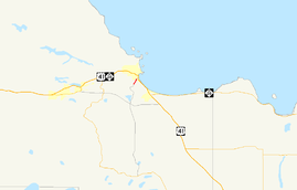
Former M-554 highlighted in redRoute information Maintained by City of Marquette Length: 0.852 mi[3] (1.371 km) Existed: October 1, 1998[1] – October 10, 2005[2] Major junctions South end:  M-553 in Marquette
North end: Division Street in Marquette Location Counties: Marquette Highway system Michigan State Trunkline Highway System
Interstate • US • State← M-553I-675  →
→M-554 was a short unsigned state trunkline highway in the US state of Michigan in the city of Marquette. This highway was transferred to the City of Marquette on October 10, 2005 in the same "route swap" that extended M-553 and decommissioned BUS US 41. Since then M-554 is now known as Division Street, and it is maintained by the City of Marquette.
Contents
Route description
The southern terminus was at the intersection with M-553 and McClellan Ave. The northern terminus was the intersection of Division St. and Pioneer Rd. The entire 0.852-mile (1.371 km) length was within the City of Marquette. This section of town is relatively flat with trees. The roadway has a few gentle curves.[4] The only signage present along the route were street signs erected by the City of Marquette.
History
M-554 was created when Marquette County Road 553 was turned over to the Michigan Department of Transportation on October 1, 1998. CR 553 became M-553 from its southern terminus at M-35 near Gwinn to the intersection with McClellan Ave. in the southern part of Marquette. The remainder of CR 553 from McClellan Ave to Division St. was given the M-554 designation.[1] On October 10, 2005, the City of Marquette and MDOT swapped jurisdiction of three roadways in Marquette. The signage was changed on November 9, 2005 reflecting the changeover of M-554 and BUS US 41 to the city's control and McClellan Avenue to the state's control. This change ended the existence of M-554.[2]
Major intersections
 A street sign at the southern terminus of now former M-554 in Marquette
The entire highway was in Marquette, Marquette County.
Mile[3] Destinations Notes 0.000 M-553 (McClellan Avenue)Former northern terminus of M-553 0.852 Pioneer Road & Division Street Road continues as Division Street 1.000 mi = 1.609 km; 1.000 km = 0.621 mi See also
References
- ^ a b "MDOT Accepts Responsibility for 120 Miles of Local Roads" (Press release). Michigan Department of Transportation. September 24, 1998. http://www.michigan.gov/mdot/0,1607,7-151-9620_11057-94859--,00.html. Retrieved August 26, 2008.
- ^ a b "MDOT and city of Marquette complete jurisdictional transfer" (Press release). Michigan Department of Transportation. November 9, 2005. http://www.michigan.gov/mdot/0,1607,7-151-9620_11057-129975--,00.html. Retrieved July 31, 2008.
- ^ a b "Control Section/Physical Reference Atlas". Michigan Department of Transportation. 2001. http://mdotwas1.mdot.state.mi.us/public/maps/pr/. Retrieved January 25, 2008.
- ^ Google, Inc. Google Maps – S McClellan Ave & M-553, Marquette, MI 49855, to County Road 553 & Pioneer Road, Marquette, MI 49855 (Map). Cartography by Google, Inc. http://maps.google.com/maps?saddr=S+McClellan+Ave+%26+M-553,+Marquette,+MI+49855&geocode=&dirflg=&daddr=M-553+%26+Pioneer+Rd,+Marquette,+MI&f=d&sll=46.516646,-87.413557&sspn=0.009391,0.014334&ie=UTF8&t=p&z=15. Retrieved July 31, 2008.
External links
Categories:- Former state highways in Michigan
- Upper Peninsula of Michigan
- Transportation in Marquette County, Michigan

Wikimedia Foundation. 2010.