- Mountain Loop Highway
-
Mountain Loop Highway
Forest Route 20,[1] Mountain Loop Scenic Byway 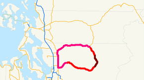
The Mountain Loop Highway is in red, the unpaved portion is
in maroon and the rest of the loop is in pink.Route information Maintained by Snohomish County/WSDOT Length: 52 mi[3][4] (83.69 km)
39 miles (paved) and 13 miles (unpaved)Existed: March 23, 1936 (Construction begins)
December 1941 (Highway opened)[2] – presentMajor junctions West end:  SR 92 in Granite Falls
East end:  SR 530 in Darrington
Highway system Forest Route System State highways in Washington
Interstate • US • State
Former PSH • 1964 renumbering • Former SRThe Mountain Loop Highway is a highway in the U.S. state of Washington. It traverses the western section of the Cascade Range within Snohomish County. The name suggests it forms a full loop, but it only is a small portion of a loop, which is completed using State Routes 92, 9, and 530. Part of the highway is also a designated and signed Forest Highway, and is known as Forest Route 20.[1]
The highway connects the towns of Granite Falls and Darrington. It is paved for 34 miles (55 km) from Granite Falls to Barlow Pass (2349') where the highway becomes unpaved for 13 miles (21 km), and then paved again for the remaining 9 miles (14 km) to Darrington. The unpaved section is U.S. Forest Service Road #20 and passes several USFS campgrounds. Portions of the unpaved section are often closed for periods of several years due to flood damage.
Between Granite Falls and Barlow Pass, the highway passes Big Four Mountain and the trailhead leading to the Big Four Ice Caves at its base. At Barlow Pass, a private road (closed to motor vehicles) branches from the highway and leads to the former silver mining town of Monte Cristo. The portion from Granite Falls to Barlow Pass follows the Stillaguamish River. The portion from Barlow Pass to Darrington follows the Sauk River. The "inside" of the highway's namesake loop is a large area containing significant Cascade peaks, including Three Fingers (6850 ft, 2088 m), Whitehorse Mountain (6850 ft, 2088 m), Mount Pugh (7201 ft, 2195 m), Mount Dickerman (5723 ft, 1744 m), Vesper Peak (6,214 feet 1,894 m), and Mount Forgotten (6005 ft, 1830 m).
Contents
Route description
Paved segment 1
The Mountain Loop Highway starts at the eastern end of SR 92 in Downtown Granite Falls. Within Downtown Granite Falls, SR 92 is called E Stanley Street and the Mountain Loop Highway is known called N Alder Street.[5] The highway goes north away from Granite Falls and turns east at the point where the road meets the South Fork of the Stillaguamish River. From there, the road roughly follows the river and intersects some Forest Routes such as FR 4201, FR 4018, FR 4020, FR 4037, FR 4052, and FR 4059 while traversing the communities of Robe, Verlot, and Silverton before the river ends.[6] The loop continues and intersects a private road that connects the highway to the Old Monte Cristo Townsite, which is located 4 miles east of Barlow Pass.
Unpaved segment
At Barlow Pass, the Mountain Loop Highway goes north, and becomes unpaved Forest Route 20 or FR 20. Shortly after becoming unpaved, FR 20 starts to follow the Sauk River towards Darrington. FR 20 goes northward past Bedal, and it becomes paved again at the new Whitechuck bridge (approximately mile marker 44).[7]
Paved segment 2
From Whitechuck, the Mountain Loop Highway continues north along the Sauk River. On the opposite side of the river, the N. Sauk River Road (Forest Route 22) parallels the route of the Mountain Loop Highway. The loop enters Darrington, where Railroad Avenue splits from the highway to become a short bypass to the eastern end of the highway. The highway ends at SR 530.[8][9]
History
The Mountain Loop Highway was established on March 23, 1936. Before the highway was built, primitive and very rough wagon roads connected the Monte Cristo Townsite with the small towns of Darrington and Granite Falls. A narrow wagon road, known as Wilmans Trail or Pioneer Trail, or simply the Sauk wagon road, was built from Sauk City on the Skagit River to Monte Cristo in 1891. That same year the surveyor M.Q. Barlow discovered the feasibility of access to Monte Cristo via the South Fork Stillaguamish River. Mining interests funded a wagon road from Silverton to the Sauk wagon road via Barlow Pass.[10] These roads roughly followed the current route of the Mountain Loop Highway along with some railroads. Construction of the road started in 1936 and finished in 1941. The road was closed in 1942 due to the war in Europe.[2]
The highway closes mostly in the winter due to floods and reopen in the spring of the following year, but a windstorm in 2003 closed the highway. With other windstorms following in 2006 and 2007, the highway had to be closed until 2008.[11]
The Mountain Loop Highway officially reopened on June 25, 2008 and the cities along the full loop (Arlington, Granite Falls, and Darrington) had a large celebration.[12][13][11][14]
Major intersections
The highway is entirely in Snohomish County, Washington.
Location Mile Destinations Notes Granite Falls 0.00 SR 92 west – Lake StevensWestern end Barlow Pass 34 Barlow Pass End of paved road, begin  Forest Route 20
Beginning of paved road, end Forest Route 20Bedal 47 North Sauk River Road Darrington 51.5 To SR 530 west (via Railroad Avenue)Bypass to SR 530 52 SR 530 north – RockportEastern end, continuation as SR 530 north Related routes
References
- ^ a b NorthwestPlaces. "Forest Route 20 Data". http://www.northwestplaces.com/trips001/MtnLoopHiway.htm. Retrieved 2008-07-13.
- ^ a b HistoryLink. "History of the Mountain Loop Highway". http://www.historylink.org/essays/output.cfm?file_id=8460. Retrieved 2008-07-13.
- ^ Wikimapia. "Mountain Loop Highway Length (Granite Falls to Silverton)". http://www.wikimapia.org/#lat=48.0744087&lon=-121.7367554&z=10&l=0&m=m&v=1&gz=0;-1396394920;900000000;0;0;0;0;497820;0;686650;0;1510620;0;1527790;0;1356120;0;1296040;0;1304630;0;1373290;0;1647950;0;2111430;0;3184320;0;8282660;0;8643150;0;9029390;0;12308120;0;13372420;0;14059070;0;14719960;0;15449520;0;17354960;0;17526630;0;17801280;0;18007280;0;20479200;0;20650860;0;21037100;0;21174430;0;21320340;0;21492000;0;22204400;0;23157120;0;23397450;0;23586270;0;23860930;0;24487500;0;25011060;0;25071140;0;24968150;0;25062560;0;25251390;0;25259970;0;25732040;0;26049610;0;27671810;0;28272630;0;28933520;0;29534340;0;29688830;0;29989240;0;30658720;0;31388280;0;31834600;0;32323840;0;32444000;0;33216480;0;33731460;0;35542490;0;35799980;0;36838530;0;37370680;0;38392070;0;39258960;0. Retrieved 2008-07-13.
- ^ Wikimapia. "Mountain Loop Highway Length (Silverton to Barlow Pass)". http://www.wikimapia.org/#lat=48.0358557&lon=-121.5609741&z=11&l=0&m=m&v=1&gz=0;-1357144550;900000000;0;0;411990;0;789650;0;1115800;0;2635010;0;3012660;0;3381730;0;4437450;0;4849440;0;5381590;0;5853660;0;6257060;0;7287030;0;7467270;0;7716180;0;7862090;0;7913590;0;8214000;0;8548740;0;9458550;0;9930610;0;10394100;0;11226660;0;11484150;0;11681560;0;12050630;0;12333870;0;12591370;0;12642860;0. Retrieved 2008-07-13.
- ^ Google Maps. "SR 92/Mountain Loop Highway Intersection". http://maps.google.com/maps?hl=en&q=Mountain%20Loop%20Highway&um=1&ie=UTF-8&sa=N&tab=wl. Retrieved 2008-07-15.
- ^ Google Maps. "Map (Granite Falls to Silverton)". http://maps.google.com/maps?hl=en&q=Mountain%20Loop%20Highway&um=1&ie=UTF-8&sa=N&tab=wl. Retrieved 2008-07-13.
- ^ Google Maps. "Map (Silverton to Bedal)". http://maps.google.com/maps?hl=en&q=Mountain%20Loop%20Highway&um=1&ie=UTF-8&sa=N&tab=wl. Retrieved 2008-07-15.
- ^ Google Maps. "Map (Bedal to Darrington)". http://maps.google.com/maps?hl=en&q=Mountain%20Loop%20Highway&um=1&ie=UTF-8&sa=N&tab=wl. Retrieved 2008-07-15.
- ^ Google Maps. "SR 530/Mountain Loop Highway Intersection". http://maps.google.com/maps?hl=en&q=Mountain%20Loop%20Highway&um=1&ie=UTF-8&sa=N&tab=wl. Retrieved 2008-07-15.
- ^ Beckey, Fred (2003). Cascade Alpine Guide: Climbing and High Routes: Stevens Pass to Rainy Pass (3rd ed.). The Mountaineers. pp. 25–29. ISBN 0-89886-423-2.
- ^ a b Gale Fiege (2008-06-25). "Towns celebrate long-awaited opening of the Mountain Loop Scenic Highway" (in English). The Everett Herald (The Everett Herald). http://www.enterprisenewspapers.com/article/20080625/NEWS01/137814809/0/ETP26. Retrieved 2008-07-15.
- ^ Mountain Loop Expirence. "Mountain Loop Reopening Celebration". http://www.mountainloopexperience.com/. Retrieved 2008-07-15.
- ^ Lukas Velush (2006-10-26). "Mountain Loop Highway reopens -- for now" (in English). The Everett Herald (The Everett Herald). http://www.heraldnet.com/article/20071026/NEWS01/710260058. Retrieved 2008-07-15.
- ^ Susan Gilmore (June 27, 2008). "Darrington, Granite Falls to celebrate reopening of Mountain Loop Highway" (in English). Seattle Times (Seattle Times). http://seattletimes.nwsource.com/html/localnews/2008020289_highway27m.html. Retrieved 2008-07-15.
External links
Categories:- Roads in Washington (state)
- Scenic highways in Washington (state)
- Forest Service Byways
- Transportation in Snohomish County, Washington
- Visitor attractions in Snohomish County, Washington


Wikimedia Foundation. 2010.