- Memramcook, New Brunswick
-
Memramcook — Village — Community of St. Joseph in Memramcook with Saint-Thomas de Memramcook Church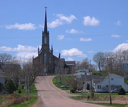

SealMotto: "Berceau de l'Acadie" (French)
"Cradle of Acadia"Location of Memramcook in New Brunswick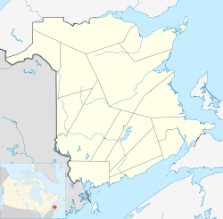
 Memramcook
Coordinates: 46°00′15″N 64°33′10″W / 46.00418°N 64.55275°W Country  Canada
Province  New Brunswick
County Westmorland Settled 1700s Incorporated 1966 Government – Type Town Council – Mayor Donald LeBlanc – Councillors List of Members- Raoul Boudreau
- Georges Gaudet
- Claude Gautreau
- Adrice LeBlanc
- Don LeBlanc
- Yolande LeBlanc
– MLA Bernard LeBlanc (L) – MP Dominic LeBlanc (L) Area – Land 185.71 km2 (71.7 sq mi) Elevation 0 - 160 m (-525 ft) Time zone AST (UTC−4) – Summer (DST) ADT (UTC−3) Canadian postal code E4K Area code(s) 506 Telephone Exchanges 334, 758 NTS Map GNBC Code 1307013 Website www.memramcook.com Memramcook (2006 population: 4,638) is a Canadian village in Westmorland County, New Brunswick. Located in south-eastern New Brunswick, the community is predominantly people of Acadian descent who speak the Chiac derivative of the French language.
The village comprises several adjacent communities including St-Joseph, College Bridge, Boudreau village, Belliveau Village, Beaumont, Fort Folly, Pré-d'en-Haut, Gautreau Village, Dover, La Montain, McGinley, Gayton, Cormiers Cove, Old Shediac Road, Memramcook-Est (Lourdes), Le Lac, Anderson Mills (Haut-du-Ruisseau), Hêtrière and Breau Creek.
Contents
History
Memramcook is called the "Berceau de l'Acadie", which translates to "cradle of Acadia". Long been inhabited by the Mi'kmaq, the site saw the arrival of Acadians in 1700.[1]
Name
The village name is originally Micmac and means "crooked river," referring to the many intricacies of the Memramcook River . The first mention of the area used the spelling Mémérancouque. The missionaries turned it intpo Memerancook , Memerancooque (1757), Memeramcook (1803), Memramkook (1812), Mamramcook (1812) and finally Memramcook . There have been several recent controversies about the name, such as people who offer the spelling Memramcouk or Memramkouke.
Deportation
In August of 1755, English soldiers were sent to Beaubassin, Petitcodiac, Chipoudy, and Memramcook to take the Acadiens prisoners. However, through guidance by the local missionary, Father LeGuerne, the Acadians hide in the woods. Then, on August 26, Lieutenant Boishébert of Miramichi and 125 soldiers and a group of Micmacs, surprised 200 Englishmen, under the command of Major Frye[disambiguation needed
 ]. The English had set fire to the church of Chipoudy and 181 homes, as well as 250 houses in Petitcodiac. Boishébert gave the order to attack at the moment that the English were setting fire to the church of Petitcodiac. After three hours of fierce fighting, the English retreated, leaving behind 50 dead, and around 60 wounded. It was thus that 200 families were able to escape the deportation.[1]
Growth
It saw its major growth, both culturally and politically, in the 18th and 19th centuries. The preservation and renaissance of the Acadian culture in Maritime Canada began in this picturesque village, largely as a result of the intervention of the seminary/collegiate at College St-Joseph - one of the founding colleges of the Université de Moncton. College St-Joseph, the first Francophone university in the Maritimes, opened its doors in the village in 1864.
It was also here in 1881 that the First Acadian National Convention was held, and where the feast of the Assumption (August 15) was adopted as the national feast day of the Acadians.
Districts
The village of Memramcook includes several hamlets, villages and neighborhoods.
On the banks of the river at the foot of Big Buttes, are, from upstream to downstream, the Pre-of-Surette (or Dover), Gautreau Village , the Pre d'en Haut , the Village des Belliveau (or to Pierre Michel) and Beaumont . These neighborhoods are more residential and rural, except Pre d'en Haut, with some services. At the top of Big Buttes are Little Dover , The Montain and The Hêtrière . St. Joseph is the main area. It is located on the eastern slope of Big Buttes, on the Mound Firecracker at the top of a meandering river.
North of St. Joseph in the valley itself are, from upstream to downstream Gaytons , Chemin-de-Shediac , Lourdes 2 and McGinley Corner . After the bridge, east of St. Joseph, is College Bridge . The Cormier Cove is located south of St. Joseph.
East of College Bridge extend Lake , located near Lake Memramcook and Memramcook East , located in a clearing beyond the highway.
Ruisseau des Breau is located in a valley of the eponymous creek , south-east of College Bridge.
Economy
Among people aged over 15 years, the participation rate is 68.0%, the employment rate is 63.9% and the unemployment rate is 5.9%, sharply down from the rate of 10.1% in 2001. By way of comparison, in the province are respectively 63.7%, 57.3% and 10.0%, meaning that the economy of Memramcook is generally healthier than the provincial average 28 .
Among these jobs, there were 3.5% in agriculture (6.9% provincially), 11.2% in construction (6.7% provincially), 9.9% in manufacturing (10, 8% provincial), 3.4% in wholesale trade (3.6% provincially), 9.7% in retail trade (11.9% provincially), 7.5% in finance and real estate (4.2% provincially), 10.1% in health and social services (11.4% provincially), 6.5% in education (6.5% provincially), 13 , 6% in services trade (16.9% provincially) and 23.6% in other services (21.1% provincially) 28 .
Among the employed population, 4.5% work at home, 12.4% have no fixed place of work and 82.8% have a fixed place of work. Among workers with a fixed place of work, 20.0% work in the village, 74.5% work elsewhere in the county, 2.9% work elsewhere in the province and 2.6% work in another province 29 .
The orchards are a major employer. In the territory including the DSL Dorchester Parish , Dorchester , Fort Folly 1 and Memramcook, there were 55 farmers in 2001 , averaging 53.7 years and a total of 45 farms. An area of 283 km 2 , 5263 ha were used 30 .
There are two branches of the Caisse populaire Dieppe-Memramcook, based in Dieppe and member of Credit Unions Acadian 31 .
Infrastructure and services
The École Abbey-Landry welcomes students from kindergarten to grade 8. Students then go to the École Mathieu-Martin in Dieppe to finish their high school.
The nearby village of Dorchester has an English school.
The library service lies in the town hall. It has nearly 14,500 books, including a small collection in English. There are also magazines, music, movies, and two computers available to the public. Located in the same building, the Community Access Centre Memramcook has 9 computers and offers training.
In the field of health , Memramcook has the Foyer Saint-Thomas de Memramcook Valley Inc.. an organization non-profit providing housing and care to elderly or disabled. The 5 residences have 100 apartments and 2 clinical extended care with 58 beds. The organization has 33 volunteers. The 2 closest hospitals are "Memorial Hospital" in Sackville which is English at a distance of about twenty kilometers, and a French speaking "Hospital George L. Dumont" which is French and located in Moncton, a distance of 30 kilometers.
The Fire Department has 48 Memramcook Fire volunteers, Raymond G. Leblanc is the Chief since 2000 while also being vice-president of the Firefighters Association of New Brunswick. The fire department was born from the merger in 2006 of services Pre d'en Haut and Memramcook. It has a central fire station in St. Joseph and a barracks secondary Pre d'en Haut, all with 5 fire trucks. The village has no post of Ambulance New Brunswick and the reaction time is considered too long. For this reason, firefighters also have two trucks and emergency are trained to handle the situation in case of accident or medical emergency, pending the arrival of ambulances 33 , 34 .
The Royal Canadian Mounted Police serves as Police municipal detachment Memramcook including a corporal and four constables. It is part of District 4 RCMP, whose headquarters is located in Shediac .
The planning is the responsibility of the Planning Commission Beaubassin whose main office is located in Shediac, but an agent is available at City Hall.
There are three post offices in Memramcook.
Notable residents and people from Memramcook
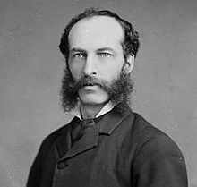 Pierre-Amand Landry
- Thomas-Jean Bourque, physician & politician
- Cormier wrestling family, professional wrestlers
- Amand Landry, Legislative Assembly NB
- David-Vital Landry, doctor, farmer, politician
- Pierre-Amand Landry, lawyer, judge, CHC
- Bernard LeBlanc, Legislative Assembly NB
- Olivier J. Leblanc, Legislative Assembly NB
- Roméo LeBlanc, Governor General of Canada
- Camille Lefebvre, priest, professor, curate
- Antoine Joseph Léger, lawyer, author, senator
- Édouard S. Léger, Legislative Assembly NB
- Greg O'Donnell, Legislative Assembly NB
- Clovis-Thomas Richard, lawyer, LANB, CBC
Climate
Climate of Memramcook Temperatures Month Jan Feb Mar Apr May Jun Jul Aug Sep Oct Nov Dec Average Record Maximum (°C) 16 15 19 28 34 34 36 37 33 26 23 18 Daily High (°C) −4 −3 2 8 16 21 24 24 19 12 6 −1 10.4 Daily Mean (°C) −9 −8 −3 3 10 15 19 18 13 7 1 −6 5.1 Daily Low (°C) −14 −13 −8 −2 4 9 13 12 7 2 −3 −10 −0.3 Record Minimum (°C) −32 −32 −27 −16 −6 −2 1 1 −3 −1 −17 −29 Precipitation and Sunshine Hours Month Jan Feb Mar Apr May Jun Jul Aug Sep Oct Nov Dec Total Total mm 109 81 103 90 99 94 100 76 92 100 97 106 1144 Rain (mm) 42 28 42 58 93 94 100 76 92 96 77 52 849 Snowfall (cm) 67 53 61 32 5 0 0 0 0 4 20 54 295 Sunshine Hours 115 124 139 158 205 229 248 244 167 142 103 95 1971 Information from Moncton International Airport 10 kilometers northwest of Memramcook, from Environnement Canada. Data taken between 1971 to 2000. External links
- Village Web site
- Monument Lefebvre National Historic Site featuring the exhibit "Odyssey of the Acadian People"
References
Subdivisions of New Brunswick Subdivisions Cities Villages Alma · Aroostook · Atholville · Baker Brook · Balmoral · Bas-Caraquet · Bath · Belledune · Bertrand · Blacks Harbour · Blackville · Cambridge-Narrows · Canterbury · Cap-Pelé · Centreville · Charlo · Chipman · Clair · Doaktown · Dorchester · Drummond · Eel River Crossing · Fredericton Junction · Gagetown · Grand Manan · Grande-Anse · Grande-Digue · Harvey Station · Hillsborough · Kedgwick · Maisonnette · McAdam · Meductic · Memramcook · Millville · Minto · Neguac · New Maryland · Norton · Paquetville · Perth-Andover · Petit-Rocher · Petitcodiac · Plaster Rock · Pointe-Verte · Port Elgin · Rexton · Riverside-Albert · Rivière-Verte · Rogersville · Saint-Antoine · Sainte-Anne-de-Madawaska · Saint-François-de-Madawaska · Saint-Hilaire · Saint-Isidore · Saint-Léolin · Saint-Louis-de-Kent · Sainte-Marie-Saint-Raphaël · St. Martin's · Salisbury · Stanley · Sussex Corner · Tracy · Tide HeadCategories:- Communities in Westmorland County, New Brunswick
- Villages in New Brunswick
- Conflicts in Nova Scotia


Wikimedia Foundation. 2010.