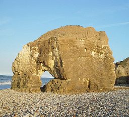
- Durham Coast
-
Durham Coast Site of Special Scientific Interest Blackhall Rocks on the Durham coastCountry England Region North East District Hartlepool,
County Durham,
Tyne and WearLocation NZ381685
to
NZ495362Area 765.41 ha (1,891.37 acres) Notification 1960 Management Natural England Area of Search Cleveland,
County Durham,
Tyne and WearInterest Biological
GeologicalWebsite: Map of site The Durham Coast is a Site of Special Scientific Interest in County Durham, England. Starting just south of Crimdon Dene, north of Hartlepool, it extends, with a few interruptions, northward to the mouth of the River Tyne at South Shields.
The area included in the SSSI includes six Geological Conservation Review sites, including Marsden Bay, a classic study area for coastal geomorphology since the 1950s.[1]
The SSSI is important both for its flora and fauna. It includes most of the paramaritime Magnesian Limestone vegetation found in Britain, a vegetation type that is unique to the Durham coast and that differs markedly from the grassland developed on similar strata elsewhere in lowland Durham.[1]
The Durham coast also supports a variety of birds, including nationally-important populations of sanderling, wintering purple sandpiper and breeding little tern. There is also a rich variety of invertebrates, including colonies of the Durham Argus butterfly, Aricia artaxerxes salmacis, and the least minor moth, Photedes captiuncula.[1]
References
- ^ a b c "Durham Coast". English Nature. 1999. http://www.english-nature.org.uk/citation/citation_photo/1000255.pdf. Retrieved 20 July 2010.
Backstone Bank and Baal Hill Woods • Baldersdale Woodlands • Bishop Middleham Quarry • Bollihope, Pikestone, Eggleston and Woodland Fells • Botany Hill • Bowes Moor • Bowlees and Friar House Meadows • Brasside Pond • Brignall Banks • Burnhope Burn • Butterby Oxbow • Cassop Vale • Castle Eden Dene • Causey Bank Mires • Charity Land • Close House Mine • Cornriggs Meadows • Cotherstone Moor • Crag Gill • Crime Rigg and Sherburn Hill Quarries • Dabble Bank • Derwent Gorge and Horsleyhope Ravine • Durham Coast • Fairy Holes Cave • Far High House Meadows • Fishburn Grassland • Foster's Hush • Frog Wood Bog • God's Bridge • Grains o' th' Beck Meadows • Green Croft and Langley Moor • Greenfoot Quarry • Hannah's Meadows • Hawthorn Dene • Hawthorn Quarry • Hell Kettles • Hesledon Moor East • Hesledon Moor West • Hexhamshire Moors • Hisehope Burn Valley • Hulam Fen • Hunder Beck Juniper • Kilmond Scar • Low Redford Meadows • Lune Forest • Mere Beck Meadows • Middle Crossthwaite • Middle Side and Stonygill Meadows • Middleton Quarry • Middridge Quarry • Moorhouse and Cross Fell • Muggleswick, Stanhope and Edmundbyers Commons and Blanchland Moor • Neasham Fen • Newton Ketton Meadow • Old Moss Lead Vein • Park End Wood • Pig Hill • Pike Whin Bog • Pittington Hill • Pow Hill Bog • Quarrington Hill Grasslands • Railway Stell West • Raisby Hill Grassland • Raisby Hill Quarry • Redcar Field • Rigg Farm and Stake Hill Meadows • Rogerley Quarry • Sherburn Hill • Shipley and Great Woods • Sleightholme Beck Gorge - The Troughs • Slit Woods • Stony Cut, Cold Hesledon • Teesdale Allotments • The Bottoms • The Carrs • Thrislington Plantation • Town Kelloe Bank • Trimdon Limestone Quarry • Tuthill Quarry • Upper Teesdale • Waldridge Fell • West Newlandside Meadows • West Park Meadows • West Rigg Open Cutting • Westernhope Burn Wood • Wingate Quarry • Witton-le-Wear • Yoden Village QuarryCity of Sunderland Claxheugh Rock and Ford Limestone Quarry • Dawson's Plantation Quarry • Durham Coast • Fulwell and Carley Hill Quarries • Gilley Law Quarry • Hastings Hill • Herrington Hill • Hetton Bogs • High Haining Hill • High Moorsley • Humbledon Hill Quarry • Hylton Castle Cutting • Joe's Pond • Moorsley Banks • South Hylton Pasture • Tunstall Hills and Ryhope Cutting • Wear River BankGateshead Gibside • Lower Derwent Meadows • Pockerley Farm Pond • Ridley Gill • Ryton Willows • Shibdon Pond • Strother Hills • Thornley WoodNewcastle upon Tyne Big Waters • Brenkley Meadows • Gosforth Park • Hallow Hill • Prestwick CarrNorth Tyneside Northumberland Shore • Tynemouth to Seaton SluiceSouth Tyneside Boldon Pastures • Cleadon Hill • Harton Down Hill • West Farm Meadow, BoldonCategories:- Sites of Special Scientific Interest in Cleveland, England
- Sites of Special Scientific Interest in County Durham
- Sites of Special Scientific Interest in Tyne and Wear
- Sites of Special Scientific Interest notified in 1960
- United Kingdom Site of Special Scientific Interest stubs
- County Durham geography stubs
Wikimedia Foundation. 2010.

