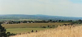
- McLaren Vale, South Australia
-
This article discusses the township in South Australia. For the wine region of the same name, see McLaren Vale.
McLaren Vale
Adelaide, South Australia
Population: 2,908 (2006 Census)[1] Established: 1838 Postcode: 5171 Area: 3.9 km² (1.5 sq mi) Location: 41 km (25 mi) from Adelaide LGA: City of Onkaparinga State District: Mawson Federal Division: Kingston Localities around McLaren Vale: Seaford Heights Old Noarlunga Onkaparinga Hills Seaford Rise McLaren Vale McLaren Flat Maslin Beach Willunga McLaren Vale (postcode 5171) is a township in the wine region of McLaren Vale in South Australia. At the 2006 census, McLaren Vale had a population of 2,908.[1]
The township was formed in 1923 from a merging of the two original villages of Gloucester and Bellevue, which were established in the 1840s by British pioneers.
The McLaren Vale wine region is well known for its dry red wines, especially those made from Shiraz, Grenache and Mourvedre. Cabernet Sauvignon, Merlot and Petit Verdot are also grown. White wine varieties in the region include Chardonnay, Semillon, Sauvignon blanc and Riesling.
In recent years innovative wineries have begun using less common varieties such as Sangiovese, Tempranillo, Barbera, Cinsaut, Vermentino and Viognier.
Children's author Alexander S. Foxhall was born in McLaren Vale, as was former Newsboys frontman Peter Furler.
The Coast to Vines rail trail passes through Mclaren Vale. There was a station at Mclaren Vale on the former Marino-Willunga rail line that it follows.
Suburbs of the City of Onkaparinga Aberfoyle Park · Aldinga · Aldinga Beach · Blewitt Springs · Chandlers Hill · Cherry Gardens · Christie Downs · Christies Beach · Clarendon · Coromandel East · Coromandel Valley · Darlington · Dorset Vale · Flagstaff Hill · Hackham · Hackham West · Happy Valley · Huntfield Heights · Ironbank · Kangarilla · Lonsdale · McLaren Flat · McLaren Vale · Maslin Beach · Moana · Morphett Vale · Noarlunga Centre · Noarlunga Downs · O'Halloran Hill · O'Sullivan Beach · Old Noarlunga · Old Reynella · Onkaparinga Hills · Port Noarlunga · Port Noarlunga South · Port Willunga · Reynella · Reynella East · Seaford · Seaford Heights · Seaford Meadows · Seaford Rise · Sellicks Beach · Sellicks Hill · Tatachilla · The Range · Whites Valley · Willunga · Willunga South · WoodcroftCoordinates: 35°14′S 138°32′E / 35.233°S 138.533°E
References
- ^ a b Australian Bureau of Statistics (25 October 2007). "McLaren Vale (Urban Centre/Locality)". 2006 Census QuickStats. http://www.censusdata.abs.gov.au/ABSNavigation/prenav/LocationSearch?collection=Census&period=2006&areacode=UCL413600&producttype=QuickStats&breadcrumb=PL&action=401. Retrieved 26 September 2011.
Categories:- Towns in South Australia
- Wine regions of South Australia
- Adelaide geography stubs
Wikimedia Foundation. 2010.
