- Maslin Beach, South Australia
-
Maslin Beach
Adelaide, South Australia
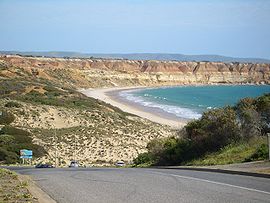
Maslin Beach recreation reserve, viewed from the north, from the outskirts of the town of the same namePopulation: 1,066 (2006 Census)[1]
1,012 (2001 Census)[2]Postcode: 5170[3] Location: 35 km (22 mi) SW of Adelaide city centre[3] LGA: City of Onkaparinga State District: Kaurna (2011)[4] Federal Division: Kingston (2011)[5] Suburbs around Maslin Beach: Moana Seaford Rise McLaren Vale Gulf St Vincent Maslin Beach Tatachilla Port Willunga Aldinga Aldinga Maslin Beach is a southern coastal suburb of Adelaide, South Australia. It is located in the City of Onkaparinga.
The name refers to the town of Maslin Beach, the beach after which it was named and the suburb which contains both. In this article, the name shall be taken to refer to the suburb, unless stated otherwise.
Contents
Geography
Maslin Beach is located between Main South Road, which forms the suburbs eastern boundary, and Gulf St Vincent.[6]
Demographics
The 2006 Census by the Australian Bureau of Statistics counted 1,066 persons in Maslin Beach on census night. Of these, 50.6% were male and 49.4% were female.[1]
The majority of residents (68.8%) are of Australian birth, with other common census responses being England (15.8%) and New Zealand (2.2%).[1]
The age distribution of Maslin Beach residents is similar to that of the greater Australian population. 71.7% of residents were over 25 years in 2006, compared to the Australian average of 66.5%; and 28.3% were younger than 25 years, compared to the Australian average of 33.5%.[1]
Community
Local newspapers include The Times and On The Coast.[7]
Facilities and attractions
The most well-known attraction in the suburb is the beach of Maslin Beach. Also known as Maslin's Beach or, simply, Maslin's, the beach is the site of a cliff-lined recreation reserve stretching from Maslin Beach town in the north to Blanche Point in the south.
In 1975, the southern half of the beach was declared Australia's first official nude beach.[citation needed] The beach is almost 3 kilometres (1.9 mi) long, so the area reserved for nude bathing is away from other beach users.
The Maslin Beach Nude Olympics are held annually, consisting of informal competitions such as three-legged races and the judging of "best bum".[8]
Parks
As well as the beach, there is also a park located between Old Coach Road and Gulf Parade.[6]
Transportation
Roads
Maslin Beach is serviced by Main South Road, connecting the suburb to both Adelaide city centre and the southern Fleurieu Peninsula.[6]
Public transport
Maslin Beach is serviced by public transport run by the Adelaide Metro.[9]
Notable residents
- John F. Davis, painter
See also
References
- ^ a b c d Australian Bureau of Statistics (25 October 2007). "Maslin Beach (State Suburb)". 2006 Census QuickStats. http://www.censusdata.abs.gov.au/ABSNavigation/prenav/LocationSearch?collection=Census&period=2006&areacode=SSC42016&producttype=QuickStats&breadcrumb=PL&action=401. Retrieved 9 May 2011.
- ^ Australian Bureau of Statistics (9 March 2006). "Maslin Beach (State Suburb)". 2001 Census QuickStats. http://www.censusdata.abs.gov.au/ABSNavigation/prenav/LocationSearch?collection=Census&period=2001&areacode=SSC41996&producttype=QuickStats&breadcrumb=PL&action=401. Retrieved 9 May 2011.
- ^ a b "Maslin Beach, South Australia (Adelaide)". Postcodes-Australia. Postcodes-Australia.com. http://www.postcodes-australia.com/areas/sa/adelaide/maslin+beach. Retrieved 9 May 2011.
- ^ "Electoral Districts - Electoral District for the 2010 Election". Electoral Commission SA. http://www.ecsa.sa.gov.au/apps/news/?year=2010. Retrieved 9 May 2011.
- ^ "Find my electorate". Australian Electoral Commission. 15 April 2011. http://apps.aec.gov.au/esearch. Retrieved 9 May 2011.
- ^ a b c Adelaide and surrounds street directory (47th ed.). UBD. 2009. ISBN 978-0-7319-2336-6.
- ^ "South Australian Newspapers". Newspapers.com.au. Australia G'day. http://www.newspapers.com.au/SA/. Retrieved 9 May 2011.
- ^ "About Maslin Beach". Maslin Beach Community Association official website. MBCA. http://www.maslinbeach.net/about.html. Retrieved 9 May 2011.
- ^ "Public Transport in Adelaide". Adelaide Metro official website. Dept. for Transport, Energy and Infrastructure, Public Transport Division. http://timetables.adelaidemetro.com.au/ttsearch.php. Retrieved 9 May 2011.
External links
- "City of Onkaparinga". Official website. City of Onkaparinga. http://www.onkaparinga.sa.gov.au. Retrieved 9 May 2011.
- "Maslin Beach Community Association". Official website. MBCA. http://www.maslinbeach.net. Retrieved 9 May 2011.
- Maslin Beach at the Internet Movie Database, a 1997 film set in Maslin Beach
Coordinates: 35°13′23″S 138°28′48″E / 35.223°S 138.480°E
Suburbs of the City of Onkaparinga Aberfoyle Park · Aldinga · Aldinga Beach · Blewitt Springs · Chandlers Hill · Cherry Gardens · Christie Downs · Christies Beach · Clarendon · Coromandel East · Coromandel Valley · Darlington · Dorset Vale · Flagstaff Hill · Hackham · Hackham West · Happy Valley · Huntfield Heights · Ironbank · Kangarilla · Lonsdale · McLaren Flat · McLaren Vale · Maslin Beach · Moana · Morphett Vale · Noarlunga Centre · Noarlunga Downs · O'Halloran Hill · O'Sullivan Beach · Old Noarlunga · Old Reynella · Onkaparinga Hills · Port Noarlunga · Port Noarlunga South · Port Willunga · Reynella · Reynella East · Seaford · Seaford Heights · Seaford Meadows · Seaford Rise · Sellicks Beach · Sellicks Hill · Tatachilla · The Range · Whites Valley · Willunga · Willunga South · WoodcroftCategories:- Suburbs of Adelaide
- Beaches of Adelaide
Wikimedia Foundation. 2010.

